
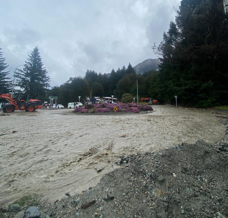
A key road in Queenstown has re-opened to stop/go traffic management after being closed for most of the afternoon.
The road at One Mile roundabout was closed at about 12.45pm after heavy rain hit the area, the Queensland Lakes District Council said.
Traffic would begin being cleared from the Queenstown CBD side using stop/go signs, a QLDC update said at 4.46pm.
Delays were expected while traffic got moving.
Queenstown council roading contractors and emergency services had been clearing debris and directing traffic.
Crews stopped water flowing on to the road just before 4pm, before working to pump the flooding clear.
Pedestrians were able to get around the closure via Thompson St Track.
The closure had affected Queenstown Primary School the collection of children from Queenstown Primary School, although it was confirmed those that could not be picked up were being looked after.
Both St Joseph’s School and Wakatipu High School had no concerns.
Traffic had been slow in either direction of Lake Esplanade, Glenorchy-Queenstown Road and Fernhill Road.
A spokeswoman for the Central Otago District Council said this morning a general warning had been issued for high winds in the Ida Valley, St Bathans and Naseby areas.
“Our teams are out monitoring and clearing debris (fallen branches). Take extra care, slow down and drive to the conditions.”
In Southland, the Milford Road (State Highway 94) is closed today due to a high risk of avalanche and a road snowfall warning is in place until tomorrow morning.
Wednesday will be a very unsettled day across the South Island:
Very heavy rain will move up the West Coast, with some spilling over into interior Otago and Canterbury.
Strong winds that could exceed 110-120 km/h will affect the interior South Island and lower North Island. pic.twitter.com/kpxHDNsO33
— NIWA Weather (@NiwaWeather) September 16, 2025
Snow may also fall about the Crown Range Road linking Queenstown and Wānaka throughout Thursday.
MetService said rain may briefly turn to snow about the summit between 7am and 11am, and up to 1cm may accumulate. Another period of colder snow was expected in the afternoon and evening, and between 3pm and 9pm up to 2cm may accumulate about the summit, with lesser amounts down to 600 metres.
Waghorn Road at Waituna Lagoon has also closed due to flooding on the road, the Southland District Council said .
The situation will be reviewed tomorrow morning.
State Highway 6 between Haast and Makarora has now reopened.
Road users should take care when driving through this route as some surface water may remain.
An area warning has also gone out about surface flooding on SH6 between Cromwell and Luggate.
Strong winds and heavy rain
MetService meteorologist Michael Pawley said more unsettled weather is on the way and it was typical for this time of year.
“We’re in that unsettled spring westerly flow at the moment and over the course of the next couple of days we’ve got a front that moves up the country. Ahead of it, we’ve got these strong winds and then heavy rain.”
A strong wind watch is in place for inland Dunedin, Queenstown Lakes, Central and North Otago until 1pm today and for Christchurch and the Canterbury Plains until 9pm. Northwesterly winds may approach severe gale in exposed places, including up to 130km/h in parts of the Canterbury high country.
“And then as that front pushes on through, we see there’s also heavy rain for the western parts of the South Island”, Mr Pawley said.
“We have an orange warning for heavy rain in the headwaters of the Otago lakes, so we’re expecting that the amount of rain that’s coming might spill over into those headwaters and cause streams and rivers to rise on that side of the divide.”
A truck rolled in the high winds in Canterbury near Stavely this afternoon, resulting in one person being airlfited to Christchurch Hospital, Stuff has reported.
Fire and Emergency (Fenz) was reported to have been called to an incident on Arundel Rakaia Gorge Rd just after 1pm.
They found the driver trapped in the truck, and crews worked to free them using hydraulic cutting equipment.
Hato Hone St John said one person was taken to Christchurch Hospital by helicopter in a moderate condition, while second person was treated at the scene.
One ambulance, one helicopter and a rapid response vehicle attended, the report said.
MetService said this morning to expect 60mm to 90mm of rain on top of what has already fallen about the main divide, and 40mm to 70mm within 20km farther east. Peak rates of up to 25mm per hour were forecast about the divide.
The warning was in place until 4pm today and Mr Pawley urged residents to be wary of streams and rivers which might rise rapidly, surface flooding, slips and difficult driving conditions.
A heavy rain watch was lifted for Fiordland from Doubtful Sound southwards by 9.30am today. However, one remains in place for the area north of Doubtful Sound, which could get between 40mm to 70mm of rain on top of what has already fallen.
There was also a possibility of thunderstorms extending north and east from the Queenstown Lakes district, Fiordland and much of Southland, including Stewart Island. These may bring localised heavy rain with intensities of 10mm to 15mm per hour, strong wind gusts of 80kmh to 90kmh, and hail of 5mm to 15mm in diameter.
Meanwhile, a heavy rain warning is in place for the ranges of the Westland district, with 120mm and 180mm more of rain on top of what has already fallen expected until 10pm today and for the ranges of the Buller district, which could get between 70mm and 100mm of rain from 6pm today until 3am tomorrow.
A heavy rain watch has been issued for the Grey and Tasman districts for 12 hours until 4am tomorrow.
Heavy rain is also forecast for the headwaters of the Canterbury lakes and rivers, south of about and south of Lake Sumner, until 10pm today. Expect 120mm to 180 mm of rain about the main divide, and 80mm to 130 mm within 20km farther east.
Once the main band of rain had passed, showers would linger in many places before clearing by the end of Friday, and temperatures would be in the low to mid-teens for most.
However, Mr Pawley said the reprieve would be short-lived because another ridge was expected to build behind the present front late on Friday.
“So, on Friday, we’re going to see some winds start to pick up in the far south ahead of the next feature, which will be making landfall towards the weekend. That’s something we’ll be keeping a close eye on.”
Avalanche risk high for Milford Road
In Southland, the Milford Road is closed from East Gate (Hollyford) to Donne River (Westgate) on Wednesday, due to heavy warm rain throughout the day increasing the avalanche hazard to high.
Milford Road Alliance advised it was likely SH94 would reopen mid-morning on Thursday after inspections and snow clearing have been carried out.
“It’s possible the road will remain open overnight tomorrow, however Friday night into Saturday morning is looking unsettled, so further travel disruptions and overnight closures may be possible.”
MetService meteorologist Lewis Ferris told RNZ this morning that Milford Sound had already seen about 130mm of rain. “Twelve hours ago they saw 100mm of rain in six hours.”
Forecast
Wednesday: Heavy and thundery rain. | Thursday: Showers gradually easing, then clearing by evening. Snow possible above about 800 metres. | Friday: Fine at first, but showers developing later with snow possible near the tunnel. | Saturday: Periods of rain, possibly heavy. Snow possible about the tunnel at first. | Sunday: Periods of rain, possibly heavy.