The Observatory has warned that Hongkongers should be prepared for high winds, flooding and very high sea levels mid-next week, as Typhoon Ragasa barrels towards the city.
 Typhoon Ragasa. Photo: HKO.
The Hong Kong Observatory (HKO) said on Sunday that heavy squally showers and thunderstorms would set in after very hot weather on Monday. “Seas will be very high with swells. Under the influence of significant storm surge, the sea level over coastal areas by then may be similar to that of Hato in 2017 and Mangkhut in 2018.”
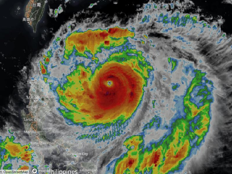 Typhoon Ragasa. Photo: Weather Underground.
Explainer: What are typhoons, and how are they linked to climate change?
Ragasa is intensifying, with it expected to move across the vicinity of [the] Luzon Strait and enter the northern part of the South China Sea, reaching Hong Kong around Wednesday.
As of Sunday, the HKO predicts the storm will be a super typhoon when it skirts the territory on Wednesday – the strongest classification, equivalent to hurricane-force.
Date timePositionClassificationMaximum sustained wind near centre08:00 HKT 22 September 202519.6 N123.3 ESuper Typhoon220 km/h08:00 HKT 23 September 202520.5 N118.3 ESuper Typhoon220 km/h08:00 HKT 24 September 202521.8 N113.7 ESuper Typhoon195 km/h08:00 HKT 25 September 202521.3 N108.7 ESevere Tropical Storm110 km/h08:00 HKT 26 September 202520.2 N104.9 ETropical Storm75 km/hSource: HKO.
HKO predicts maximum sustained winds of 220 km/h near the centre of the storm by Tuesday.
If a T10 signal – the HKO’s highest storm warning signal – is hoisted on Wednesday, it means hurricane-force winds are blowing or expected to blow.
What happens during a T10 storm? – click to view
Citizens are urged to stay indoors and away from exposed windows and doors.
Temporary shelters for people with no safe refuge will be opened.
All government facilities and all schools will be closed.
There will be no bus or ferry services, but trains will run in the underground sections of some MTR lines, if conditions permit.
If the eye of the tropical cyclone passes directly over Hong Kong, there may be a temporary lull. The Hong Kong Observatory warns that this lull will be followed by a sudden resumption of violent winds, so residents in a safe place should stay where they are.
Google’s experimental Weather Lab, powered by AI, predicts Ragasa will be closest to Hong Kong between around 2am and 8am on Wednesday.
 Typhoon Ragasa’s path. Photo: Google.
Typhoon Hato struck South China in late August 2017, leaving 12 dead in Macau and on the mainland. Locally, it caused severe flooding, storm surges of up to four metres, and widespread debris from collapsed advertising signs and trees.
 Photo: Tom Grundy/HKFP.
Typhoon Manghut in 2018 was the strongest to hit the city since 1983, leaving thousands of travellers stranded and billions of dollars of damage in its wake.
Tropical cyclones – which get their energy from warm ocean water – are strengthening and becoming ever more destructive because of warming seas. Over 90 per cent of excess heat in the atmosphere is ending up in oceans, according to NASA, as rising greenhouse gases prevent it from escaping to space.
Support HKFP | Policies & Ethics | Error/typo? | Contact Us | Newsletter | Transparency & Annual Report | Apps
Safeguard press freedom; keep HKFP free for all readers by supporting our team
![]()
![]()