
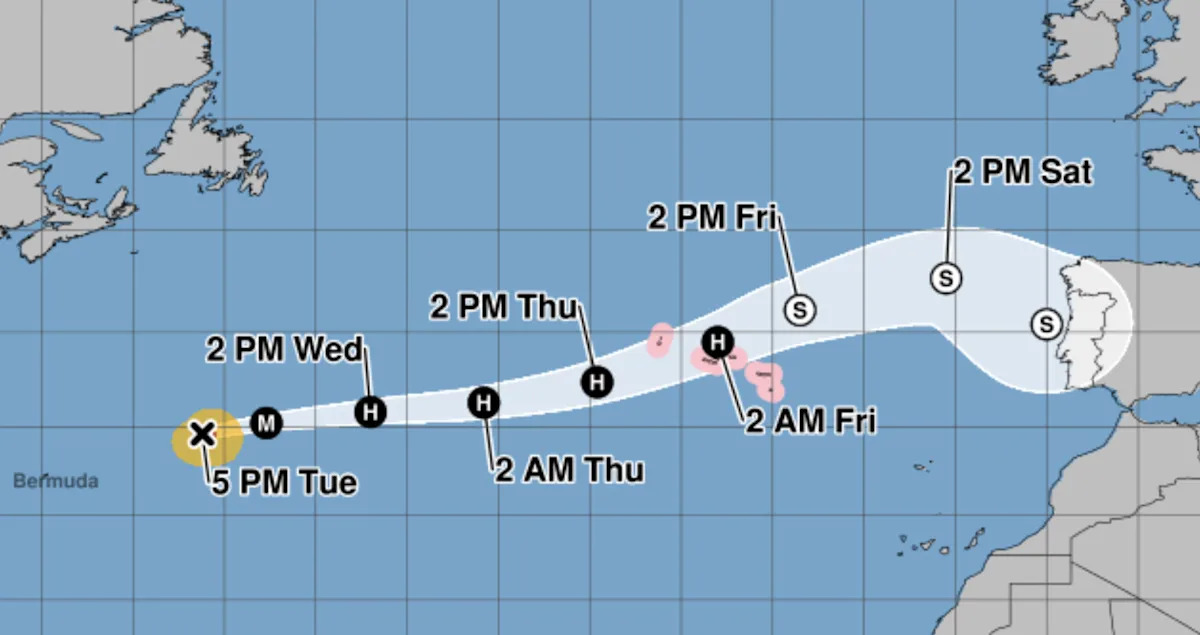
Hurricane Gabrielle is still a powerful hurricane but appears to have reached the peak of its intensity, according to the latest advisory from the National Weather Service.
The storm, still a Category 4 as of Tuesday afternoon, strengthened into a hurricane on Sunday afternoon. It’s moving eastward back across the Atlantic Ocean on a path that could take it “very close to or over” the Azores, a group of islands about 900 miles off the coast of Portugal. The storm is expected to weaken considerably over the next two days but is still forecast to be at hurricane strength by the time it reaches the Azores.
Gabrielle will also continue to create dangerous swells for Bermuda and parts of the eastern United States for the next few days.
“These swells are likely to cause life-threatening surf and rip current conditions,” the NWS warned.
Where is the storm now, and what is its path?
Gabrielle is currently located about 520 miles east-northeast of Bermuda.
It has maximum sustained winds of 130 mph (Category 4 hurricanes have sustained winds of 130-156 mph).
It’s moving east-northeast at 21 mph.
How strong will Gabrielle become?
The storm appears to have reached its peak strength as a Category 4 hurricane and is expected to weaken as it tracks across the Atlantic. The most recent forecasts predict Gabrielle will be either a Category 1 or Category 2 hurricane as it approaches the Azores on Thursday. A dangerous storm surge is expected to produce “significant coastal flooding” when the storm makes landfall in the Azores.
Are more storms developing?
The NWS is currently tracking two systems in the eastern Caribbean that could develop into tropical depressions in the coming days. One system is considered to have a roughly 60% chance of developing over the next week, while the second has been given a 90% chance of developing in the next week. At the moment, there’s no indication that either system is on track to become a hurricane.
Forecasters are also monitoring Hurricane Narda off the Pacific coast of Mexico, which was upgraded from a tropical storm overnight. As of Tuesday afternoon, Narda was a Category 1 hurricane with sustained winds of 85 mph. It’s expected to gain strength in the coming days as it makes its way west into the open ocean, with its winds peaking at 110 mph.
How is hurricane season shaping up?
Government forecasters anticipated an “above-normal” Atlantic hurricane season this year, with between five and nine hurricanes.
Gabrielle is the seventh named storm and the second hurricane of the season, which started in June and runs through the end of November. The first was Hurricane Erin, an incredibly powerful storm that reached Category 5 last month. Erin caused nine deaths in the island nation of Cape Verde off the western coast of Africa, but turned northward before reaching the U.S. mainland. Though Erin never made landfall, the storm caused significant flooding along the East Coast and created rough seas that caused at least two deaths along beaches in the Northeast.
Even an above-average hurricane season this year would be a relief compared with 2024, which featured multiple devastating hurricanes that struck the Gulf Coast. Hurricane Helene caused at least 250 deaths and led to catastrophic flooding throughout the southern U.S. when it struck in late September last year. Less than two weeks later, Hurricane Milton — one of the most intense Atlantic hurricanes ever — pummeled Florida.