
The stage is set for an unusual situation in the tropics as two potential storm systems try to organize in close proximity to each other off the U.S. East Coast over the next week.
How the forecast unfolds in the coming days is very much uncertain as the systems interact with each other and move through the wake of major Hurricane Gabrielle and other influencing weather conditions.
That uncertainty, forecasters say, should have the U.S. coast, the Bahamas and Bermuda on alert for a potential storm. The next two named storms, Humberto and Imelda, are likely to form over the next week as tropical storms or hurricanes, AccuWeather lead hurricane expert Alex DaSilva said.
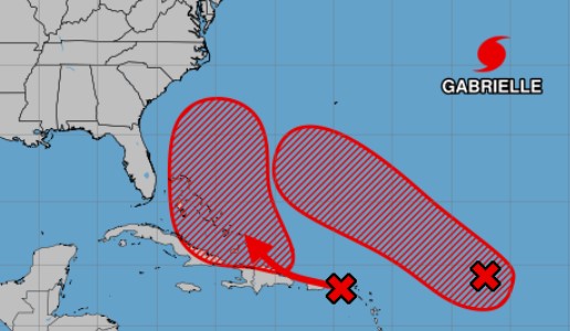
The system located in the central Atlantic has an 90% chance of developing in the next two days. Forecasters with the National Hurricane Center said Wednesday that it is likely to stay well north of the Caribbean.
“An unusually high percentage of the potential tracks show the system developing into a large, strong hurricane in the general vicinity of Bermuda,” Fox Weather Hurricane Specialist Bryan Norcross wrote on his blog, Hurricane Intel.
The storm has a high chance of becoming a hurricane in the coming days and causing impacts far from its center, DaSilva said.
“This storm will likely create rough surf and rip currents that could impact beaches across the Bahamas and the East Coast starting this weekend,” DaSilva said. “People in Bermuda and along the East Coast should monitor forecast updates closely. The storm may develop quickly.”
The second tropical wave that is located in the Caribbean has a 80% chance of developing in the next week and has come farther west than any other tropical system so far this season. It is likely to become a tropical depression while near the Bahamas, the National Hurricane Center said.
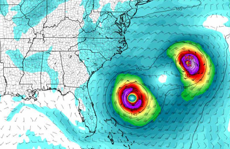
 The National Hurricane Center is watching two areas for possible formation of tropical depressions, storms or even hurricanes. (NHC/Courtesy)
“Most computer forecasts show the depression or storm tracking north off the Florida coast in the general direction of North Carolina,” Norcross said. “But enough forecasts curl it toward the coast into Florida, Georgia, or South Carolina that everyone is going to have to watch it closely.”
Any impact to the U.S would be late in the weekend or early next week, Norcross said. But he added that the long-range forecast is murky.
“A fundamental rule of forecasting is that forecasts for disorganized, just-organizing, or slow-moving systems are subject to larger than normal errors and subject to change. This system looks to check two of those boxes,” he said.
Spaghetti models — the combined forecast paths generated by the various storm modeling computers — show the closer system potentially tracking near the mid-Atlantic coast from the Carolinas to Virginia.
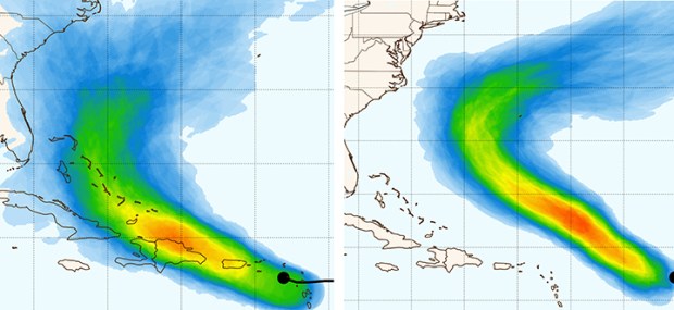 Computer models, known as the spaghetti models, show the potential forecast tracks of two systems expected to develop near or north of the Bahamas over the next week. (Courtesy https://www.polarwx.com)
The two tropical waves will be in close proximity to each other, and the potential for them to interact is complicating the forecast.
“For now, we just have to watch and be aware that something annoying could develop with this system around the weekend,” Norcross said.
Meanwhile, a hurricane warning was in effect for the Azores on Wednesday as Hurricane Gabrielle approaches at Category 3 strength.
Its swells are affecting Bermuda and the U.S. East Coast from North Carolina northward and could create dangerous surf and rip currents.
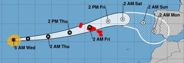 The latest forecast track of Hurricane Gabrielle. (National Hurricane Center/Courtesy)
So far in 2025, there have been seven named storms, including two hurricanes.
Originally Published: September 24, 2025 at 8:27 AM EDT