
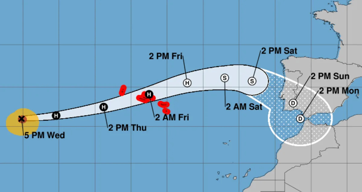
Hurricane Gabrielle has weakened considerably, but it is still a powerful hurricane as it progresses eastward across the Atlantic. The storm, which was a Category 4 as of Tuesday evening, has since dropped to a Category 2 with sustained winds of 100 mph.
Gabrielle’s current path is expected to take it near or directly over the Azores, a group of islands about 900 miles off the coast of Portugal. Though it is expected to continue to weaken, the storm is still on track to be at hurricane strength when it reaches the Azores late Thursday. A hurricane warning has been issued for the entire island chain.
Gabrielle will also continue to create dangerous swells for Bermuda and parts of the eastern United States for the next few days, according to the National Weather Service.
Where is the storm now, and what is its path?
Gabrielle is located in the open ocean about 1,000 miles west of the Azores.
It has maximum sustained winds of 100 mph (Category 2 hurricanes have sustained winds of 96-110 mph).
It’s moving east at 28 mph.
How strong will Gabrielle become?
The storm is now well past its peak strength, which topped out at 140 mph winds on Tuesday. It’s expected to become weaker as it approaches the Azores. The most recent forecast projects Gabrielle to be at the high end of Category 1 for the next two days before dropping below hurricane strength over the weekend. A dangerous storm surge and several inches of rain are expected to produce “significant coastal flooding” when the storm makes landfall in the Azores.
Are more storms developing?
The NWS designated a new tropical storm, Humberto, on Wednesday afternoon. Humberto is expected to become a hurricane on Saturday and potentially gain strength to become a Category 2 storm over time. There is “quite a bit of uncertainty” about its path, but current forecasts expect Humberto to turn northward before it reaches the East Coast of the United States.
Forecasters are monitoring another system in the eastern Caribbean that has a high likelihood of becoming a tropical storm by this weekend. At this early stage, there is a lot of variance in the models of what this system, which would be named Imelda if it does become a storm, might do. It’s possible that Imelda could impact Florida and parts of the southeastern coast, according to the Weather Channel.
Hurricane Narda is also still moving westward off the Pacific coast of Mexico. Narda strengthened into a Category 2 storm with sustained winds of 105 mph as of Wednesday morning. The storm is expected to continue moving westward into the open ocean for the next several days before making a sharp turn to the north this weekend. While that would put Narda on a path toward the west coast of Mexico, the storm is expected to become weak enough at that point to be downgraded to a post-tropical storm.
How is hurricane season shaping up?
Government forecasters anticipated an “above-normal” Atlantic hurricane season this year, with between five and nine hurricanes.
Gabrielle was the seventh named storm and the second hurricane of the season, which started in June and runs through the end of November. The first was Hurricane Erin, an incredibly powerful storm that reached Category 5 last month. Erin caused nine deaths in the island nation of Cape Verde, off the western coast of Africa, but turned northward before reaching the U.S. mainland. Though Erin never made landfall, the storm caused significant flooding along the East Coast and created rough seas that caused at least two deaths along beaches in the Northeast.
Even an above-average hurricane season this year would be a relief compared with 2024, which featured multiple devastating hurricanes that struck the Gulf Coast. Hurricane Helene caused at least 250 deaths and led to catastrophic flooding throughout the southern U.S. when it struck in late September last year. Less than two weeks later, Hurricane Milton — one of the most intense Atlantic hurricanes ever — pummeled Florida.