
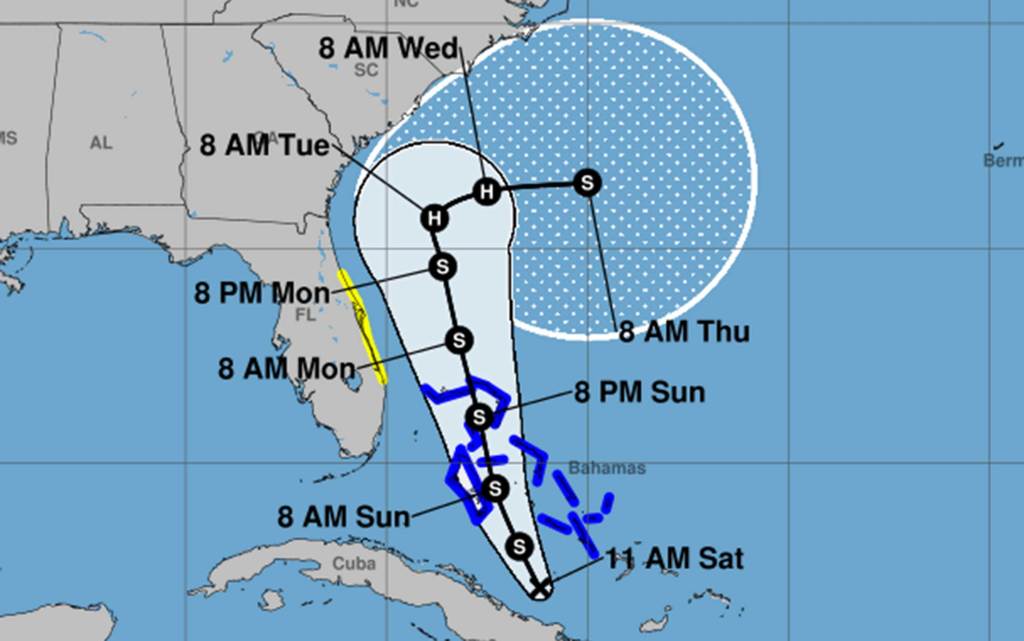
A tropical storm watch was issued Saturday morning for the east coast of Florida as the season’s ninth tropical cyclone formed near the Bahamas and was forecast to grow into Tropical Storm Imelda, according to the National Hurricane Center.
The watch issued at 11 a.m. spans from the Palm Beach/Martin county line north to the Flagler/Volusia county line.
The NHC’s 2 p.m. advisory has the center of newly formed Tropical Depression Nine about 120 miles south-southwest of the central Bahamas moving northwest at 6 mph with maximum sustained winds of 35 mph.
“A north-northwestward motion is expected to begin later today and continue through Monday,” forecasters said. “On the forecast track, the center of the system is expected to move across the central and northwestern Bahamas this weekend and approach the southeast U.S. coast early next week.”
The system is forecast to become a tropical storm by Saturday night and a hurricane by late Monday or Tuesday.
The updated cone of uncertainty, though, no longer includes Florida in its long-range path as it had in the 5 a.m. forecast.
“Moisture from Tropical Depression Nine will lead to a threat of heavy rainfall well to the north from Coastal Georgia through the Carolinas and into the southern Mid-Atlantic states into early next week which could cause flash, urban, and river flooding,” forecasters said.
11 am EDT – System becomes Tropical Depression Nine just north of eastern Cuba. Tropical Storm Watch issued for portions of the east coast of Florida. Here are the Key Messages. Visit https://t.co/tW4KeGe9uJ for updates. pic.twitter.com/i5HyJ43Tdh
— National Hurricane Center (@NHC_Atlantic) September 27, 2025
Still, the proximity will lead to hazardous conditions on the Florida coast, according to the National Weather Service in Melbourne, which stated the system “is forecast to make an uncomfortably close pass near Florida late Sunday through Monday, with ensemble guidance continuing to favor a northward motion as it parallels the coast.”
The watch includes all of Central Florida’s Atlantic coast including Volusia, Brevard, Indian River, St. Lucie and Martin counties.
Increasing swells will lead to 15-foot seas in offshore waters while breaking waves of 6-8 feet are expected on Florida’s east coast as early as Sunday afternoon.
The NWS expects to issue a high surf advisory Sunday with a high risk of rip currents and minor to moderate beach erosion.
“It is important to note that there is still a level of uncertainty relative to rain and wind impacts, and any shifts in the track of (the system) will influence whether these threats increase or decrease,” the NWS stated.
The forecast is complicated by the possibility that Hurricane Humberto in the Atlantic and what could become Imelda, positioned close to each other, will interact in unpredictable ways.
One of the uncertainties is what forecasters call the Fujiwhara effect — when two adjacent tropical cyclones can begin to rotate around one another. That makes predicting tracks more difficult and the reason for such a large cone of uncertainty in the long-term forecast.
A tropical storm warning was also issued for portions of the northwestern Bahamas including Eleuthera, New Providence, the Abacos, Berry Islands, Andros Island and Grand Bahama Island and the central Bahamas including Cat Island, the Exumas, Long Island, Rum Cay and San Salvador.
“Interests elsewhere in the Bahamas and along the southeast coast of the United States from Florida to North Carolina should monitor the progress of this system,” NHC stated.
Winds should begin hitting the central Bahamas on Saturday night or early Sunday then moving into the northwestern Bahamas on Sunday.
The system continues dumping rain over eastern Cuba, where 8-12 inches could fall with some areas getting as much as 16 inches and 4-8 inches expected in the Bahamas. The totals prompted warnings of flash and urban flooding while mudslides are possible in high-terrain areas across eastern Cuba as well as Hispaniola and Jamaica.
Storm surge could be from 1-3 feet above ground level on the northwestern Bahamian island coasts.
Swells from this system as well as distant Humberto will begin hitting the Bahamas and Florida this weekend and spread to the rest of the U.S. coast early next week. The swells could bring life-threatening surf and rip current conditions.
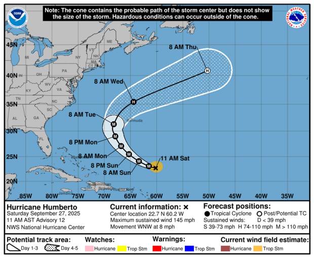 Hurricane Humberto forecast path as of 11 a.m. Saturday, Sept. 27, 2025. (NHC)
Farther out in the Atlantic, the season’s third hurricane had grown into a major storm late Friday.
As of NHC’s 11 a.m. advisory, Humberto had intensified further with maximum sustained winds of 145 mph, making it a Category 4. It was located about 720 miles south-southeast of Bermuda and 365 miles north-northeast of the Caribbean’s northern Leeward Islands moving west-northwest at 8 mph.
“A turn toward the northwest is anticipated on Sunday. Humberto is forecast to then turn northward by Tuesday,” forecasters said. “Some strengthening is possible today. Humberto will likely remain a powerful major hurricane for the next several days.”
Hurricane-force winds extend out 25 miles and tropical-storm-force out 105 miles from its center.
Its forecast path could bring it over Bermuda.
The two other hurricanes this season have been Erin and Gabrielle, both reaching major hurricane status.
The National Oceanic and Atmospheric Administration in early August updated its season forecast to call for 13-18 named storms, of which five to nine would grow into hurricanes. Two to five of those would develop into major hurricanes of Category 3 or higher.
Hurricane season runs from June 1 to Nov. 30.
Originally Published: September 27, 2025 at 6:00 AM EDT