
With increasing certainty forecasters are warning that the entire Philadelphia region is in for a disruptive soaking wind fest from a potent coastal storm during what is one of the year’s busier travel weekends.
“It’s going to be bad,” said Paul Fitzsimmons, a lead meteorologist at the National Weather Service Office in Mount Holly. “It’s going to be a nasty, stormy ‘nor’easter’ … lasting right into Monday.”
New Jersey has declared a state of emergency to go into effect 11 p.m. Saturday continuing into Monday.
The weather service has issued a deluge of advisories and watches, among them the potential for “major” flooding along the Jersey coast — which is already under flood advisories unrelated to the storm.
Hours of onshore winds gusting up to 70 mph are possible at the beaches, the weather service warned, with a “potential for these strong winds to continue well into Monday.” Inland, gusts up to 50 mph could occur in the Philly area.
“Power outages and tree damage are possible,” the weather service said.
Widespread rains of 2 to 3 inches, with isolated totals of up to 5 inches, were in the forecasts from what is expected to be a slow-moving storm with long duration impacts.
When will the Philly region feel the storm’s effects
Given that the storm was still in the formative stages Friday, details on timing and impacts at specific locations are likely to remain elusive — even as they are happening.
However, rains in advance of the storm may begin during the day Saturday at the Shore, and perhaps in the early evening around Philly. (At least that won’t be an issue for the Phillies or their fans.)
Gusty winds from the east and northeast — thus the term “nor’easter” — are due to pick up dramatically on Sunday as the storm travels north along the coast. The Shore could experience steady onshore 40-mph winds with gusts to 60 mph from noon until 11 p.m. Sunday.
Not that potential gusts to 40 mph and heavy rains would be a day at the beach in the immediate Philly region.
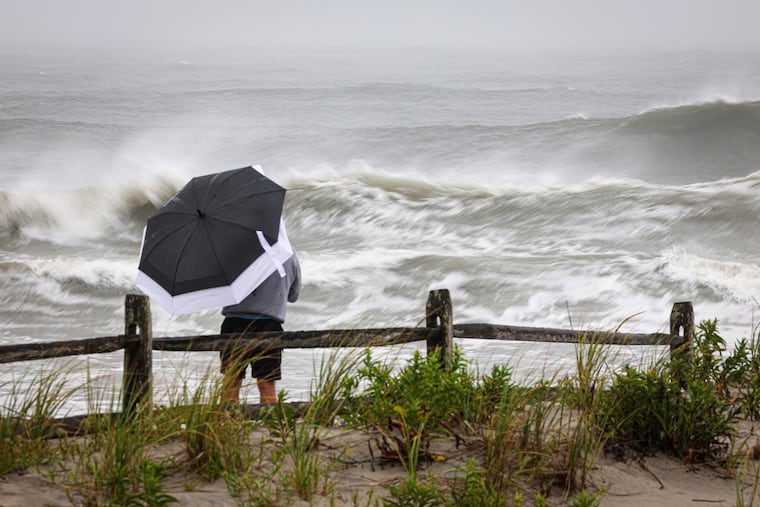
But the storm has the potential to be destructive at the Shore, where the weather service said impacts would include “coastal flooding, beach erosion, dune breaching,” and “potentially damaging winds.”
Emergency management officials were making preparations Friday. Ocean City advised residents to get ready to move their cars to the streets at slightly higher elevations and “to secure loose items and furniture.”
It also advised boat owners to get their crafts out of the water if possible.
The storm’s long duration is ominous for the Shore
Storm waves are likely to erase significant sand from the beaches, which the weather service says are going to experience flooding during multiple high tide cycles.
“Major” flooding is expected around noon Sunday, and again at 1 p.m. Monday, the weather service says. Major flooding also was anticipated in the back-bay areas in the early afternoon on both Sunday and Monday.
The agency warned that “widespread” roadway flooding and “structural damage” are possible.
And, “some locations may become isolated by the floodwaters,” it said.
The duration may have one upside
The Delaware River at Washington Avenue was forecast to crest close to moderate flood levels at 6 p.m. Monday as the river responds to the rains.
Rains may continue through Monday, and the timing of the storms coincides with a holiday weekend traditionally popular for leaf-peeping foliage trips.
However, the fact that the rains are going to be falling over such a prolonged period should have a dampening effect on the inland stream flood potentials.
In addition, the skies have been chary with rain lately. Officially, Philadelphia has received only about a third-of-an-inch of rain this month, about one-third of normal.
“I do not expect widespread flooding from the rains,” said Alex DaSilva, AccuWeather’s chief hurricane forecaster.
Ultimately, the flooding potential will have a lot to do with the intensity and path of a storm whose genesis has been the source of some controversy.
Is this actually a tropical storm?
AccuWeather Inc., one of the nation’s largest commercial weather services, is calling this a “tropical wind and rainstorm,” arguing that it will be juiced by the ultra-warm waters of the Gulf Stream and will take on tropical characteristics.
In a news release, the company criticized the National Hurricane Center for neglecting to note that the system potentially could qualify as a “named” tropical system.
“Our concern is that some people may not be taking this storm as serious without an indication that the storm will be named,” the company said in the release.
In an emailed statement, hurricane center spokesperson Maria Torres said that given the government shutdown, the center would respond only to “mission-critical” queries.
For its part, the weather service in Mount Holly began issuing detailed impact briefings Wednesday afternoon, updating them twice daily.
Even in anonymity, all indications were that the storm eventually would make a name for itself.