
A nor’easter is expected to bring flooding, power outages and cold weather to Massachusetts starting Sunday night.
Multiple warnings have been issued, including a coastal flood advisory and a high wind warning, for areas in the eastern part of the commonwealth.
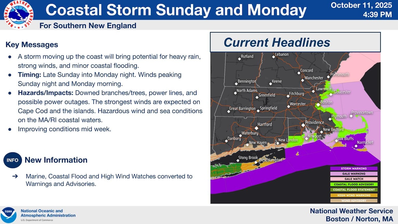
Read more: Nor’easter in Mass.: 5 maps show what to expect
Here’s what you need to know about Sunday’s storm.
 A storm is expected to bring flooding, power outages and cold weather to Massachusetts starting Sunday night.National Weather ServiceWhat is a nor’easter?
A northeast coastal storm, known as a nor’easter, have impacts similar to a hurricane.
The name comes from the fact that it has winds that blow from a northeasterly direction over coastal areas.
Nor’easters typically occur between October and May. During winter months, nor’easters often bring heavy snow. But they can include high winds, heavy rainfall, flooding, rip currents and beach erosion. Nor’easters can often last several days, affecting multiple tide cycles.
When does the storm start?
Rain could begin as early as 11 a.m. in Boston and the Cape and Islands on Sunday. Although it could hold off until about 4 p.m. in Boston.
Central Massachusetts could see rain starting around noon on Sunday. And Western Massachusetts could see rain starting around 3 p.m. but is more likely to start around 5 p.m.
When does the storm end?
The rain isn’t going away.
Once the rain begins in Boston on Sunday afternoon, it’s likely to continue until Tuesday afternoon. And there’s a chance it could continue until Tuesday night.
Similarly, rain in Central Massachusetts will last until Tuesday. However, it is more likely to end earlier in the day on Tuesday.
Rain in Western Massachusetts could end by 1 a.m. Tuesday morning.
On the Cape and Islands, rain could last until Wednesday.
Coastal flood advisory
The coastal flood advisory has been issued for the coast until 6 p.m.
The National Weather Service warns that there could be flooding of lots, parks and roads.
“If travel is required, allow extra time as some roads may be closed. Do not drive around barricades or through water of unknown depth. Take the necessary actions to protect flood-prone property,” the weather service wrote.
High wind warning
The National Weather Service is warning about dangerous winds for areas near Nantucket, Vineyard Haven and NewShoreham.
Northeast winds could have gusts up to 55 mph.
The warning remains in effect until 2 p.m. Monday.
“Damaging winds will blow down trees and power lines. Power outages are possible. Travel will be difficult, especially for high profile vehicles,” the weather service wrote, adding that people should remain in the lower levels of their homes, avoid windows and watch for falling debris and tree limbs.
What is expected later this week?
The storm is expected to bring below normal temperatures for mid to late week, according to the weather service. This could be as much as 10 degrees below normal.
Highs on Thursday may struggle to reach the low 50s, the weather service predicted.
If you purchase a product or register for an account through a link on our site, we may receive compensation. By using this site, you consent to our User Agreement and agree that your clicks, interactions, and personal information may be collected, recorded, and/or stored by us and social media and other third-party partners in accordance with our Privacy Policy.