
A burst of wild weather has cut power, toppled trees and sent shipping containers tumbling like Lego in Dunedin after wreaking havoc in Southland.
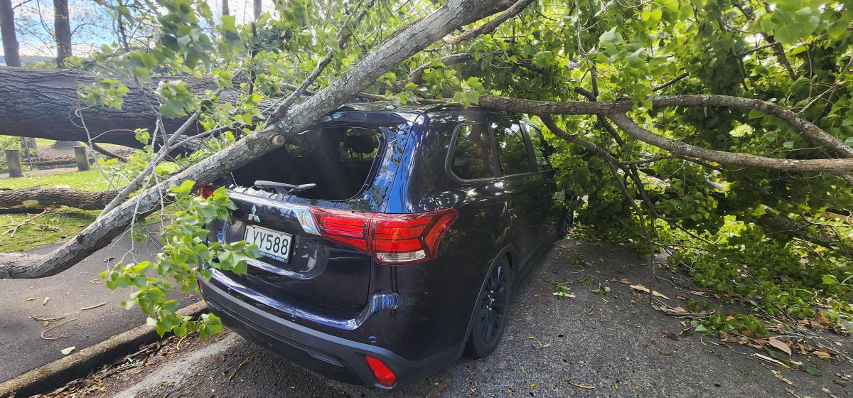
A person in Dunedin received minor injuries when they were hit by a flying trampoline and Hato Hone St John was also called to the scene when a tree branch fell on a car in the city today, but nobody was hurt.
One person suffered moderate injuries in a weather-related crash on the Milton Highway in the afternoon, a spokesman said.
Dunedin Mayor-elect Sophie Barker drove along Portsmouth Dr on her way home and said she saw “many trees down and debris everywhere”.
“People need to be very sensible. Stay home. Stay safe.”
Fire and Emergency NZ crews were kept busy responding to weather-related callouts across the country.
Assistant National Commander Ken Cooper says between 7.40am and 5pm today, crews were called to 587 incidents.
“Wellington and Canterbury saw the most callouts in the early morning, before Southland was hit hardest at lunchtime.”
Crews responded to 228 calls between 11.55am and 5pm in Southland, including 155 in Invercargill.
“This is for things like roofs lifting, trees down, power lines down, garage doors, fences and sheds blowing away. The rain has stopped, and the wind has eased, so now crews will now be looking to assist with clean-up across the region.”
In Dunedin, Aurora Energy was showing widespread outages in Mosgiel and power cuts in Caversham, North East valley and Brighton.
Multiple large trees are down in Anzac Avenue and across the city.
The wind also caused some damage to the Dunedin Ice Stadium roof and at Forbury Park in Victoria Rd, while the Dunedin Railway Station lost tiles from part of its roof.
Forsyth Barr Stadium suffered minor damage to some roof flashings, the Dunedin City Council said.
DCC contractors have logged more than 50 jobs across the city’s roading network, mainly involving fallen trees.
There are 13 road closures in effect and contractors are clearing and reopening roads only where it is safe to do so.
The road closures include Highcliff Rd, while Portobello Rd is down to one lane in places. A full list of road closures can be found here.
Further south, multiple highways in Southland are affected.
In Dunedin, the biggest gust recorded by Port Otago’s wind equipment was a gust of 170kmh at Taiaroa Head at 1.50pm.
In the inner city, the biggest gust recorded was 100kmh at 1.40pm at the T-shed on the wharf.
A stack of containers at Ravensbourne was toppled by the gusts.
Port Otago chief executive Kevin Winders said multiple 40ft closed and empty dry shipping containers were moved by the wind at the Ravensbourne container depot.
‘‘They each weigh about two-and-a-half tons, so the wind was pretty intense to be able to move them around like that.’’
He said their team at the depot ‘‘did a great job,’’ and were prepared for them to potentially topple.
Winds were still ‘‘quite blustery,’’ and the clean-up would not begin to start until they died down. They would use titan cranes to re-stack the containers tomorrow if possible.
No staff members were around the containers when they went down, Mr Winders said.
The Dunedin Botanic Garden is closed for the rest of today due to the high winds and increased risk of tree and branch fall.
A video shows students running as trees come down outside the University of Otago Business School.
A caravan has been tipped on its side at Allanton, blocking the bridge across the Taieri River.
Dunedin Airport’s website shows multiple cancellations and many flights in and out of Queenstown Airport have also been cancelled.
Motorists use chainsaws to clear Portobello Rd
Keith Dickson, of Dunedin, said two big lines of trees had come down on Portobello Rd about a 1km apart near Glenfalloch.
He was at the front of a line of cars, he predicted hundreds were caught up on the road, that had to stop for fallen trees.
He had praise for his fellow Dunedin citizens, who, he said, came together to clear one lane and let vehicles pass.
About 15 people, three with chainsaws on hand, from different cars got out and started cutting off and pulling at branches to clear a path.
“I’m just really proud of Dunedin people because everyone got out of their cars and, without complaint, worked like we were a team, I’m amazed.”
The road remained “extremely dangerous”, he felt, and urged caution for anyone needing to drive there.
“The cliffs there don’t look great, it’s bloody dangerous. There’s going to be a hell of a lot of work there to clean up and stabilise it all.”
‘Bang’ of wild weather
MetService meteorologist Claire O’Connor said the south was mostly in the clear after the ‘‘bang’’ of bad weather that just made its way through Southland and Otago.
‘‘The main stronger winds are moving off to the east now – you’ve probably noticed the temperature has had a bit of a drop as well.’’
Dunedin reached 25°C just before the winds hit, and dropped right down to 15°C within half an hour after they had passed over the city.
The South may still get a few strong gusts, but the worst had so far subsided.
Southland smashed in sudden burst
MetService upgraded its Southland and coastal part of Clutha to a red warning just before noon, with a forecast of damaging gusts of 150kmh in exposed places.
By 1pm the wild wind had reached Balclutha, cutting power and sending debris flying.
Southland was hit hard, with Invercargill city’s top gust reaching 137kmh and Gore getting a 125kmh gust.
O’Connor aid this was due to the region getting the brunt of the front after it came from the sea.
‘‘It passed over land and the friction of the land can just disrupt everything and make it separate a bit more… that will cause that to slow down, sort of drags on everything a bit.
‘‘Over sea, things will tend to pick up because there’s just the ocean surface there – in this case, the land dragged back those speeds a bit there.’’
The Southwest Cape, at the southern tip of Stewart Island, for example, got the full brunt of the wind as it came from the sea, she said.
The station recorded a top gust of 190kmh. ‘‘It’s straight off the ocean there.’’
Tree ‘came out of nowhere’
A coffee van owner in Invercargill got a big shock when a large tree crashed on her bonnet as she was driving today.
The Shot South owner Justine Abbott told RNZ said she was on North Rd when the tree “came out of nowhere.”
She had just decided to head home in the worsening weather conditions.
“I started slowing down, and it went ‘boom.'”
Abbott said she had escaped without injury, but the van was “pretty much written-off.”
In her shock, she said she rang to organise a replacement vehicle before she even got out of the van. She hoped to be back in business next week.
Invercargill City Council said multiple trees fell across the city and flying debris posed a serious safety risk.
A freight truck and trailer tipped over on State Highway 1 between Clinton and Waipahi.
Roads were closed across the city including Elles Rd, Inglewood Rd, Queens Dr from Herbert Str to Rugby Par and SH1 East Road.
Otago Daily Times reporter Toni McDonald said conditions suddenly changed for the worse just before 12pm.
She said looking out the window on to The Crescent she could see a sign being ripped off its pole.
The sign on Allied Media’s building had also been ripped from the sign of the building and the street was flooded.
She said the weather suddenly turned “ballistic” and she had never seen anything like it.
Emergency services were later called to the area. Debris were flying everywhere across the road, fences were blown over and a garden shed flattened.
As the wild weather came through the number of outages listed on PowerNet’s website quickly multiplied.
All Invercargill bus services are suspended until further notice and parks and reserves in Invercargill and Bluff are closed.
Bluff Service Centre was also closed for the rest of the day.
Chaos in Mataura
A Mataura man described scenes of destruction around Mataura and Edendale.
Lines of trees along the sides of the road between Gore and Edendale were down, as were farm shelterbelts and fencelines, half the roof of a $150 million long life cream plant under construction at Fonterra at Edendale had blown off and a trampoline had blown on to his neighbour’s roof.
Power and water were out in Mataura – he understood Gore District Council staff had been unable to get to the water treatment plant to turn the emergency generators on.
The man, in his early 50s, had lived in Mataura his whole life and had never seen wind like it, he said.
It was still “blowing it’s t*** off” at 2.50pm, and the wind had been going since 10am.
He said the wind was coming from the east, which was unusual.
Southern highways closed
Road closures and warnings are in place around Southland after high winds have brought down trees and power lines.
State Highway 96, Mataura to Hedgehope, due to power lines down. Road users should follow the directions of emergency services.State Highway 93, Mataura, between State Highway 1 and Kaiwera Road, due to fallen trees. No detour available.State Highway 1, Mataura, between the intersections of Glendhu Road and Charlton Road, due to fallen trees. The detour for northbound traffic is to turn left on to Glendhu Road, right on to Townsley Road, left onto McBride Road, right on to Charlton-Siding Road, then left back onto SH1. The reverse applies for southbound traffic.State Highway 1, Mataura, near the intersection with Craigs Road, due to downed power lines.State Highway 1, Glengarry, between the intersections of Mill Road and Racecourse Road, due to fallen trees. The detour for northbound traffic is to turn left on to Racecourse Road, right onto Findlay Road, right on to Mill Road N and left back on to SH1. The reverse applies for southbound traffic.State Highway 6, Invercargill, Don Street to Tay Street due to adverse weather conditions (for southbound road users only).State Highway 1, between Gore and Balclutha, due to strong winds.State Highway 87 between the intersections of Gladfield Road and Riverside Road, due to downed power lines. Road users should use an alternative route or delay their journeys.
Southern Lakes
Power is out to more than 1000 customers in the Southern Lakes area.
Aurora Energy’s website shows widespread outages including in Queenstown, Glenorchy, the outskirts of Wanaka, Te Anau and Makarora.
The Queenstown Lakes District Council says its emergency operations centre is tracking rain, river and lake levels across the district.
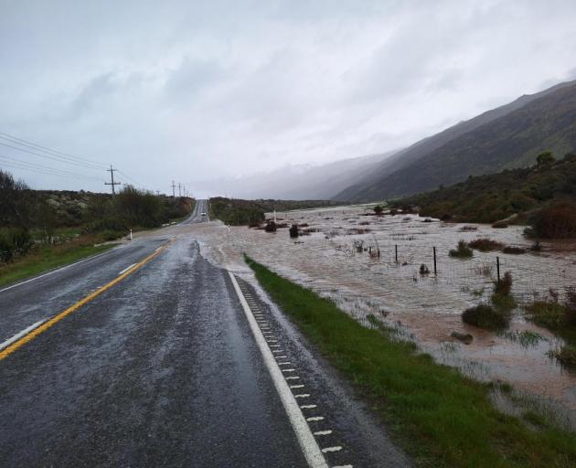
The following roads are closed due to flooding:
SH6 (Haast Pass) between Makarora and Haast.Mount Aspiring Road after the Treble Cone turn-off; there is currently no access to Mount Aspiring National Park.Glenorchy-Paradise Road at the Rees River Bridge.Rees Valley Road north of Glenorchy.Glenorchy-Queenstown Road at One MileMoke Lake Road at RP 3.17 (i.e. third cattlestop).
Many other roads are affected by surface flooding and rockfalls; please drive with extreme caution – slow down, increase following distances and keep headlights on.
Leslie van Gelder, who lives in the Rees Valley, told the Otago Daily Times she lost power about 11am.
The Rees Valley Rd was closed by the Queenstown Lakes District Council about 9.30am.
 ‘‘It was kind of expected, which would go first, the road or the power,’’ Ms van Gelder said.
‘‘It’s pretty wild up here. I’m guessing the eye of the storm is coming through … we’ve just had wind that was circular, not a tornado – I’ve never seen that before.’’
Lakes Wakatipu and Wanaka should be peaking tomorrow morning, the Otago Regional Council says.
ORC’s general manager science and resilience Tom Dyer said MetService has now cancelled its orange heavy rain warning for the Otago headwaters and most rivers have peaked and were falling.
“While the rain has largely passed both Lake Wakatipu and Lake Wanaka are still expected to rise over the next 24hours,” Mr Dyer said.
He cautioned that while many rivers were now receding around the Queenstown Lakes area, further rain forecast for later today could prompt some rivers to rise again.
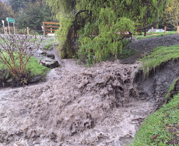
The Dart River peaked late this morning at a flow of 2080 m3/s. This is the second-highest flow in the monitoring record for the ‘Dart at the Hillocks’ site, since monitoring began in June 1996.
Around Queenstown there was potential for surface flooding and localised ponding in low-lying areas of Beach St, Rees St, Marine Parade, Church St, Earl St, as water entered through the stormwater system, with precautionary sandbagging under way.
Low-lying parts of Kingston township were expected to flood, while in Glenorchy the outlook remained unchanged from yesterday.
The Glenorchy lagoon was predicted to overtop the Glenorchy floodbank, and flooding of the northwest part of the township was still likely on Thursday night.
Queenstown Airport sustainability and corporate affairs general manager Sara Irvine said while there were a lot of people at the terminal who had been disrupted, but due to the extent of the cancellations across the domestic and international networks ”it’s not very crowded”.
Ms Irvine said staff had been advising passengers due to travel today to contact their airline directly, or check the Queenstown Airport website for the most up-to-date information.
“We know that some of the airlines will make decisions a bit later in the day … going into the long weekend there could be some ad-hoc flights to try and support disrupted passengers, but that’s not confirmed.”
Those who were due to travel from Queenstown Airport this weekend were also advised to consider alternative methods of getting to the airport, such as park and ride, because ”it’s likely the Queenstown Airport parks will be quite full”.
– Allied Media