
The Gulf Coast Storm Team is monitoring the movement of Tropical Storm Melissa in the Caribbean Sea. The storm is now projected to become a major hurricane by early next week. As of 5 a.m. Thursday, Melissa’s center is located 325 miles to the south-southwest of Port-au-Prince, Haiti. Though the storm is still generating maximum sustained winds of 50 mph, its forward speed has significantly slowed in the last 24 hours. At last check, the storm’s forward motion is now to the west-northwest at just 3 mph. Despite Melissa’s current designation as a tropical storm, the system is battling strong wind shear and some moderately dry air in the mid-levels of the atmosphere. These two factors act as limiting factors to tropical systems if they persist for long periods of time.At the moment, the storm is in a weak steering environment, which is why its forward speed is expected to remain slow through the rest of the week.Melissa’s anticipated slow forward motion makes the National Hurricane Center forecast cone more of a circular shape all the way through the upcoming weekend. By early next week, though, as the storm stays over warm water, Melissa is projected to strengthen into a major hurricane. The most recent forecast cone released by the National Hurricane Center calls for the storm to be at Category 4 strength by Monday.Another reason for the forecast cone’s circular shape is that Melissa’s long-term track remains uncertain, as forecast models do not have a common solution on where the system will move in the coming week. A stronger storm is more favored to curve north faster, while a weaker storm is more likely to remain in the Caribbean longer. Because of Melissa’s proximity to land, though, the storm will bring numerous threats to the eastern Caribbean, with heavy rain and landslides expected in Haiti and the Dominican Republic.A hurricane watch has been issued for southern Haiti, and a tropical storm watch is in effect for Jamaica.While it is too soon to determine Melissa’s long-range movement, the most likely track at this time is for a cold front to eventually pull Melissa north into the open Atlantic next week.Impact on FloridaThere are no immediate threats to the Gulf Coast at this time, and the chances for long-range impacts remain low.For now, steering currents appear to be working in Florida’s favor by likely steering the storm away from the peninsula in the future.We will continue to keep you updated on Melissa through the platforms of Gulf Coast News.Watch the 2025 hurricane special: ‘Gulf Coast Weather: Plan, Prepare & Protect’The Atlantic hurricane season runs from June 1 through Nov. 30. Follow Gulf Coast News online and on air for Southwest Florida’s Most Accurate weather forecast.Be prepared with the Gulf Coast News 2025 Hurricane GuideLive Interactive RadarCheck out the interactive Gulf Coast Live RadarWatch your Gulf Coast Weather forecasts on TV or onlineHere’s where to find our latest weather forecast videoYou can also watch newscasts live or on demand hereOr download the Gulf Coast News app to stream on your phone or tabletYour Gulf Coast Storm TeamChief Meteorologist Allyson RaeMeteorologist Caroline CastoraMeteorologist Jim DickeyMeteorologist Jason DunningMeteorologist Lauren HopeMeteorologist Raphael TavernierMeteorologist Rob DunsMeteorologist Sara BlueDOWNLOAD the free Gulf Coast News app for your latest breaking news and weather alerts. And check out the Very Local Gulf Coast app to stream news, entertainment and original programming on your TV.
FORT MYERS, Fla. —
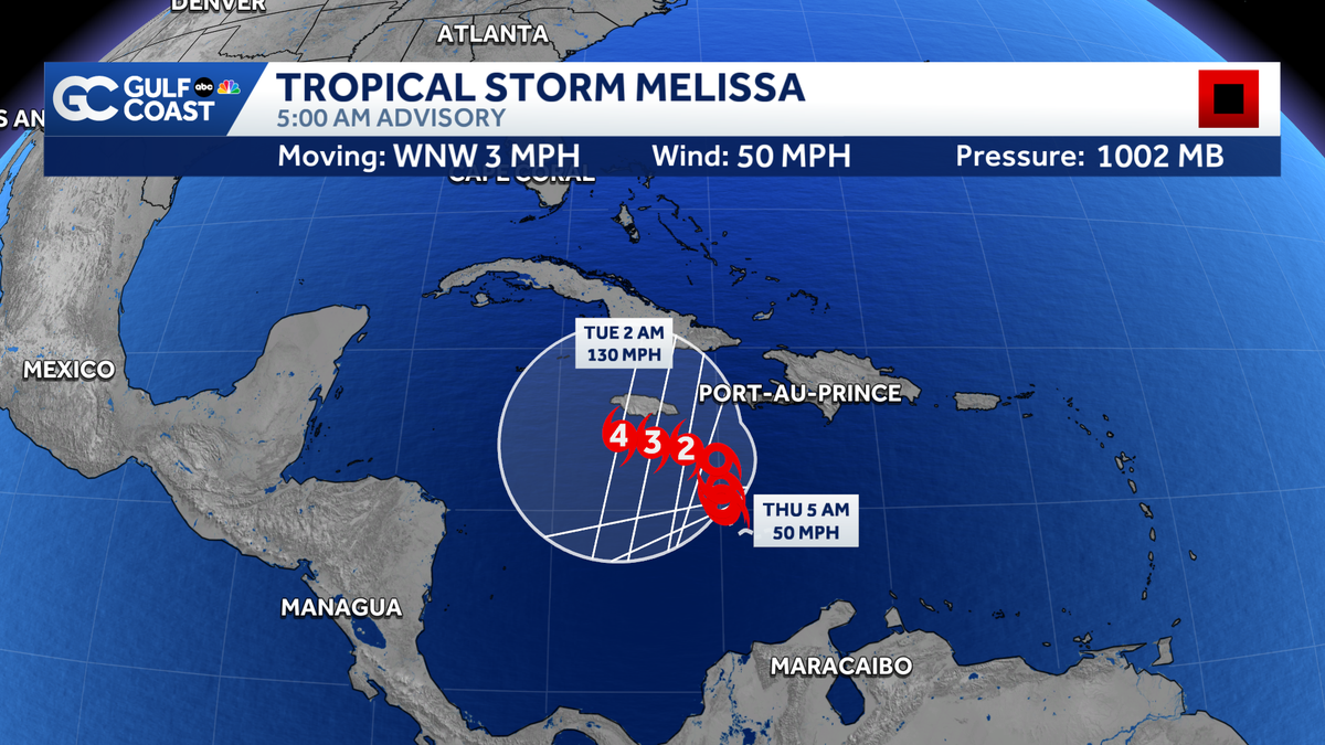
The Gulf Coast Storm Team is monitoring the movement of Tropical Storm Melissa in the Caribbean Sea. The storm is now projected to become a major hurricane by early next week.
As of 5 a.m. Thursday, Melissa’s center is located 325 miles to the south-southwest of Port-au-Prince, Haiti. Though the storm is still generating maximum sustained winds of 50 mph, its forward speed has significantly slowed in the last 24 hours.
At last check, the storm’s forward motion is now to the west-northwest at just 3 mph.
![]()
Gulf Coast News
Tropical Storm Melissa Satellite.
Despite Melissa’s current designation as a tropical storm, the system is battling strong wind shear and some moderately dry air in the mid-levels of the atmosphere. These two factors act as limiting factors to tropical systems if they persist for long periods of time.
At the moment, the storm is in a weak steering environment, which is why its forward speed is expected to remain slow through the rest of the week.
Melissa’s anticipated slow forward motion makes the National Hurricane Center forecast cone more of a circular shape all the way through the upcoming weekend. By early next week, though, as the storm stays over warm water, Melissa is projected to strengthen into a major hurricane.
The most recent forecast cone released by the National Hurricane Center calls for the storm to be at Category 4 strength by Monday.
![]()
Another reason for the forecast cone’s circular shape is that Melissa’s long-term track remains uncertain, as forecast models do not have a common solution on where the system will move in the coming week. A stronger storm is more favored to curve north faster, while a weaker storm is more likely to remain in the Caribbean longer.
![]()
Because of Melissa’s proximity to land, though, the storm will bring numerous threats to the eastern Caribbean, with heavy rain and landslides expected in Haiti and the Dominican Republic.
A hurricane watch has been issued for southern Haiti, and a tropical storm watch is in effect for Jamaica.
While it is too soon to determine Melissa’s long-range movement, the most likely track at this time is for a cold front to eventually pull Melissa north into the open Atlantic next week.
Impact on Florida
There are no immediate threats to the Gulf Coast at this time, and the chances for long-range impacts remain low.
For now, steering currents appear to be working in Florida’s favor by likely steering the storm away from the peninsula in the future.
We will continue to keep you updated on Melissa through the platforms of Gulf Coast News.
Watch the 2025 hurricane special: ‘Gulf Coast Weather: Plan, Prepare & Protect’
The Atlantic hurricane season runs from June 1 through Nov. 30. Follow Gulf Coast News online and on air for Southwest Florida’s Most Accurate weather forecast.
Live Interactive Radar
Watch your Gulf Coast Weather forecasts on TV or online
Your Gulf Coast Storm Team
DOWNLOAD the free Gulf Coast News app for your latest breaking news and weather alerts. And check out the Very Local Gulf Coast app to stream news, entertainment and original programming on your TV.