
Weather warnings are expanding Thursday to a Flood Watch issued for North Vancouver Island and a High Streamflow Advisory for Vancouver Island – West, East and South, says the BC River Forecast Centre.
Environment Canada’s forecasted storm system on Wednesday for B.C.’s coastal areas remains in place until Friday with rainfall and wind warnings, as well as advisories from the BC River Forecast Centre.
On Wednesday afternoon, the centre issued a Flood Watch for North Vancouver Island, and a High Streamflow Advisory for western, eastern, and southern parts of Vancouver Island – from Sooke to Campbell River.
“Heavy rain and high streamflow bring increased risk for unstable banks, river erosion, submerged roads, swift water hazards, flooding and landslides,” says the ministry.
By Friday, the BC River Forecast Centre says to expect heavy rainfall between 60-150+ milimetres on West and North Vancouver Island, and 20-50+ mm on East and South Vancouver Island.
No significant rise in temperatures is expected, but higher elevation areas could see snow.
Flood Watch
The ministry says due to the heavy rainfall, North Vancouver Island could see a rise in river levels.
“A flood Watch means river levels are rising and may lead to high river banks, and flooding of areas near affected rivers,” states the centre.
The public is warned to “stay clear of the banks of swift running rivers and never drive across flooded roads, bridges or river crossings.”
The ministry is also reminding households to keep storm drains clear.
“At this time of year leaves can clog storm drains and impact urban drainage.”
High Streamflow Advisory
A high streamflow advisory is in place for West, East and South Vancouver Island.
“A High Streamflow Advisory means that river levels are rising or expected to rise rapidly, but that no major flooding is expected. Fast-flowing bodies of water increase risk to life safety. Minor flooding in low-lying areas is possible,” states the centre.
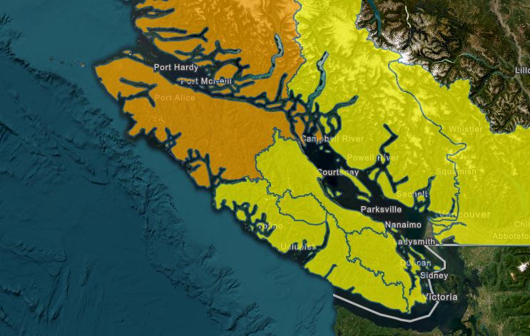 Yellow indicates areas under a High Streamflow Advisory and Orange indicates areas under Flood Watch. (BC River Forecast Centre, as of Oct. 22, 3 p.m.PT).
Rain warning
As of Thursday morning at 4 a.m., Environment Canada’s rainfall warning for west and inland Vancouver Island remains in place, with 80 to 140 mm of rain expected near Gold River and Zeballos throughout Thursday and overnight.
“In the wake of the front, the rain will taper to showers overnight or early Friday morning. The highest rainfall amounts are expected over the northwestern portions of the regions, near Gold River and Zeballos,” EC says.
Near Bowser and North Courtenay, between 40 to 70 mm of rain is expected Thursday afternoon and into Friday morning.
“The highest rainfall amounts are expected around Squamish and Port Mellon in Howe Sound, and near Bowser and North Courtenay on East Vancouver Island,” states Environment Canada.
Wind warning
Strong winds are expected over exposed coastal locations across the Sunshine Coast and West Vancouver Island, north of Fanny Bay, says EC.
“Winds will increase to southeast 70 gusting to 90 km/h in exposed areas near the Strait of Georgia late this morning and persist through the evening. Winds will ease overnight as the front moves inland.”
On the west coast of northern Vancouver Island, southeast winds of 90 km/hr, gusting to 110km/hr are expected Thursday throughout the day.
“A vigorous frontal system moving southeastward across the B.C. coast brings very strong winds to coastal regions,” says EC.
Environment Canada warns the public to avoid wooded areas and campers should find sturdy shelters to prevent injuries from falling trees or branches.
“Loose objects may be tossed by the wind and cause injury or damage. High winds may result in power outages and fallen tree branches.”
Find the latest weather updates, alerts and warnings at Environment Canada. To report severe weather, send an email to BCstorm@ec.gc.ca or post reports on X using #BCStorm.
Visit the River Forecast Centre for the latest updates. For information on how to prepare for flood hazards, visit PreparedBC.