
Strong winds and heavy rain triggered landslides in the northern end of Vancouver Island early Friday morning.
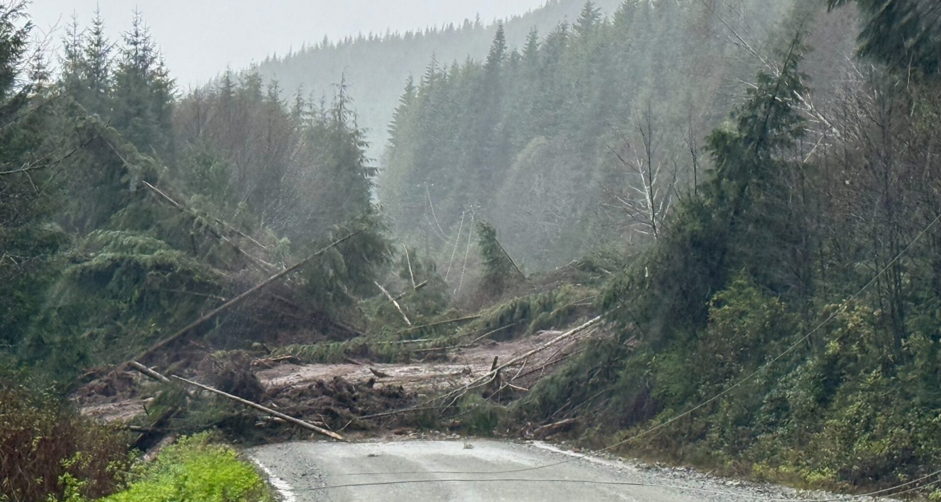
A photo from BC Hydro shows trees, mud and debris scattered across a road in the Winter Harbour area between Holberg and Port Hardy.
Meanwhile, DriveBC warned of a road closure along Head Bay Road, about five kilometres away from Highway 28, between Gold River and Tahsis early Friday morning.
Shortly after 3 a.m., DriveBC said that Head Bay Road was completely closed because of the washout, and that no detour was available. It also said crews were on scene.
Around 7:15 a.m., Mainroad North Island Contracting said it had crews at the Head Bay Road landslide “performing tree and mudslide removal” and that it would try to have one lane open by Friday afternoon.
It also asked drivers to obey traffic laws and slow down and move over for road workers.
Across the North Island – from Port Hardy down to Deep Bay, past Courtenay – DriveBC is warning of heavy rain and potential water pooling along Highway 19, Highway 19A and Highway 28.
 Roadways highlighted in yellow are being impacted by weather, such as heavy rain or rain pooling on roads. (DriveBC)
The landslide and rain alerts from DriveBC come as Environment Canada rainfall warnings and wind warnings remain in effect for much of Vancouver Island
Rainfall warnings
In West Vancouver Island and Inland Vancouver Island, a rainfall warning is in effect early Friday morning where another 20 to 30 millimetres of rain is expected, according to Environment Canada.
In East Vancouver Island, 40 to 70 millimetres of rain is expected Friday from approximately Bowser to North Courtenay.
“Heavy downpours can cause flash floods and water pooling on roads. Localized flooding in low-lying areas is possible,” warns Environment Canada.
“If visibility is reduced while driving, slow down, watch for tail lights ahead and be prepared to stop.”
Wind warning
A wind warning also in effect for East Vancouver Island, from roughly Courtenay to Campbell River, with gusts between 70 to 90 km/h expected Friday morning.
“Loose objects may be tossed by the wind and cause injury or damage. High winds may result in power outages and fallen tree branches,” said the weather office.
The winds along East Vancouver Island are expected to ease later Friday morning.
Meanwhile, in Greater Victoria, a special weather statement is in effect due to strong winds of 60 to 80 km/h early Friday morning. The winds are expected to ease throughout the morning before returning again on Saturday afternoon, according to Environment Canada.
RELATED: BC Ferries cancels sailings between Vancouver, Victoria and Nanaimo due to wind
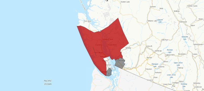 Areas under weather warnings (red) and special weather statements (grey) as of Friday morning are shown. (Environment Canada)
On Thursday afternoon, the BC River Forecast Centre also issued a flood watch for North Vancouver Island, and a high streamflow advisory for all other areas of the Island.
A flood watch, which is less severe than a flood warning, means river levels are rising and will approach or exceed their banks, with possible flooding in adjacent areas.
A high streamflow advisory is less severe than flood watch, and means river levels are expected to rise rapidly but that “no major flooding is expected,” though some minor flooding is possible.
READ PREVIOUS: Weather warnings expand to flood watch and high streamflow advisories on Vancouver Island