

Tasman’s mayor says there are “tired and exhausted” people in his communities as residents prepare for heavy rain and strong wind forecast to hit the region today.
Yesterday MetService issued orange heavy rain warnings and strong wind watches for parts of the country, expected to continue into this afternoon.
This morning, MetService meteorologist Heather Keats told Breakfast “some strong wind gusts” picked up last night before the fronts arrived.
“Places like Kaio, Cape Reinga, they’ve had gusts of up to 124km/h,” she said.

“The strongest gust has actually been the Methven high country, they had a gust of about 238km/h, but that’s expected, we see that a lot. It’s elevated. It’s quite exposed.”
Auckland Harbour Bridge recorded gusts of just under 90km/h this morning.
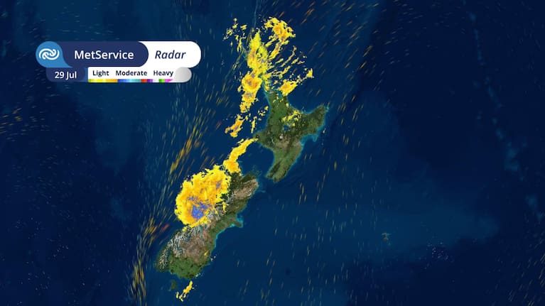
“The rain is just starting to tick up, so some of those totals, about 100mm in the last 12 hours for Kaikohe.
“For the Tasman ranges, obviously a point of interest, they’ve had 60mm so far, but those totals will very much increase significantly across the day.”
Keats said swell height was also increased due to the northerly wind direction.
“We’re seeing increased wave height for areas that are normally quite sheltered, so places down the Hauraki Gulf, Waiheke, Rangitoto Island, even some of the North Shore beaches in Auckland can expect some coastal hazardous conditions today.”
“Places of most concern is still in Tasman, specifically east and south of Motueka, but that excludes Nelson City districts. So there is still a high chance that that could be upgraded to a red warning today.
Heavy rain was forecast through until 9pm today.
“Heavy rain is the biggest concern with this system. Places like the Coromandel, Bay of Plenty. They can expect up to 200mm of rain and there’s going to be downpours as well because thunderstorms are likely especially this afternoon and evening as those fronts move through.”
Tasman residents ‘over it’
Tasman was one of the regions in the firing line for more bad weather, with Mayor Tim King saying the biggest areas of concern were “key areas around the upper Wai-iti Valley and the upper Motueka Valley” which were both impacted during the two previous weather events in June and July.
“The rain kind of runs from 6am this morning through to kind of early evening today. So heaviest rain [in the] middle of the day coincides with high tides and also high winds expected in the middle of the day as well.”
“But the warning covers a fairly large part of the district and it will depend a lot on the wind direction as to exactly where the impacts may end up being,” he said.
King said the strong wind would be an issue, particularly for bringing down trees.
“One of the big issues in the last event on July 11 was the amount of trees that came down across wide parts of the district, but particularly the roading network, to just be very aware of the wind and also does shift where the impact might be. Change in wind direction can mean the rain impacts in different areas.”
He said residents were “well and truly over it”.
“There’s certainly lots of people [stressed] after the first two events, and obviously with this one being forecasted, it’s a whole other level of stress.
“It is phenomenal how resilient particularly rural communities are to these events and the amount of work that’s gone on over the two weeks. We’ve had two really good weeks of weather and the volunteer effort, the work of landowners, council contractors has been amazing.
The morning’s headlines in 90 seconds, including the atmospheric river arrives, Epstein’s girlfriend pushes for appeal, and Jennifer Lopez’s wardrobe malfunction. (Source: Breakfast)
“We’re in as good a place as we can be, given the last kind of four or five weeks to deal with this event, and that’s largely down to the massive effort of both land owners, volunteers and council contractors and staff.”
He said the river and roading networks were “so heavily impacted”.
“The last two weeks of very good weather has certainly helped in terms of preparation. But yeah, people are well and truly over it. So there’s a lot of very tired and exhausted people, and the impact on people’s properties is tragic to go and visit and just hear their stories.”
Heavy rain warnings were issued for the Coromandel Peninsula, the Bay of Plenty, Central North Island mountains, Taranaki Maunga, Tasman from Motueka westwards, Nelson City District and Marlborough (west of Havelock and north of the Wairau River), Tasman east and south of Motueka (excluding Nelson City District), the ranges of Westland District, the headwaters of Canterbury lakes and rivers, and the headwaters of Otago lakes and rivers.
Late on Monday, MetService issued an orange heavy rain warning for Auckland from 4am until 10pm on Tuesday. “Expect 90 to 130 mm of rain. Peak rates of 15 to 25 mm/h, but 25 to 40 mm/h possible in localised downpours during Tuesday afternoon and evening,” said the warning, which included Great Barrier Island. A strong wind watch was also in place overnight Monday until 6pm on Tuesday,
The southeast of the Tasman region had a high chance of being upgraded to a red warning, MetService said.