
Another week down and another weekly roundup on all things cities. Can you believe it’s almost summer?
This Week in Greater Auckland
This roundup, like all our work, is brought to you by the Greater Auckland crew and made possible by generous donations from our readers and fans. If you’d like to support our work, you can join our circle of supporters here, or support us on Substack.
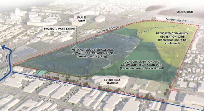
Only a few days left on the AF Thomas Park consultation
Consultation on the proposed changes to the AF Thomas Park to create more flood resilience for the North Shore closes on the 23rd of November.
Make sure to have your say!
With just days remaining until public consultation closes, Auckland Council is calling on residents and community groups to share their vision for the future recreational use of A F Thomas Park. This is the final chance for Aucklanders to help shape the park’s transformation into a unique destination following major blue-green infrastructure works currently in design.
Opportunity to Shape a Landmark Park
The proposed transformation of A F Thomas Park is a landmark project, featuring both new flood storage wetlands and dry flood detention areas designed to increase flood resilience in the Wairau catchment. The park, given its size and amenities, could stand out in the future as a resilient, multi-use open space, with the potential to rival other iconic Auckland destinations such as Cornwall Park.
Spinoff Firing
There were some great pieces from The Spinoff this week.
Public transport in Auckland is actually pretty good
First up we have Hayden Donnell noting that public transport in Auckland is actually pretty good.
When politicians started getting serious about congestion charging in Auckland in 2023, RNZ went to ask people on the street what they thought of the idea. The response was unanimous. “Firstly, we need more access to public transport and probably more affordability for that as well,” said Emily. “Those ideas only work in places where there’s viable alternative transport options,” said Simon. “The alternatives really need to be in the form of very, very efficient and easy-to-use public transport,” said Public Transport Users Association chair Niall Robertson.
The interviewees were repeating received wisdom. As the saying goes, only two things are certain in life: death and Auckland’s public transport network sucking balls. The idea of putting a charge on people driving to work seems, in the words of Emily, “outrageous”, when you’ve only encountered a sparsely serviced network of diesel-chugging buses and often cancelled trains.
But is that actually a fair reflection of Auckland’s public transit system as it currently stands? Though it might be a controversial, even viscerally disgusting thing to say, these days public transport in Auckland is in many respects fine, and in a number of areas, bordering on good.
…..
The change has been profound and relatively speedy by transport project standards. In 2016, Auckland only had seven frequent transit routes, which Auckland Transport defines as lines where buses run every 15 minutes between 7am and 7pm, seven days a week. By 2022, that number had risen to 29. This year it has 43. AT expects to add five to seven more to get to 50 by 2030. The numbers are startling, and more so when they’re drawn up on a map.
MRCagney Auckland Frequent Transit Network Map. Image credit: MRCagney
On Auckland’s Congestion
Hayden had another great piece explaining why Auckland’s traffic is bad in one map.
The root of the dilemma is starkly illustrated in a recent Statistics NZ release with the snappy title “Subnational population estimates: At 30 June 2025”. It contains a map showing New Zealand’s annual population change broken down by district. Selwyn is expanding. Ruapehu is shrinking. But inset is a breakdown of Auckland’s population data organised by local board area, and it reveals the city has got things, to use the official planning terminology, arse backwards.
The central suburbs of Auckland are dying while the rest grow. (Image: Statistics NZ)
Not only are the central suburbs of our biggest city failing to grow; they’re shrinking at a rate similar to the Tararua district, which is home to a place RNZ described as “the town you’ve never heard of”. Though that may have been harsh to Herbertville, its growth still shouldn’t be on par with areas that sit next to the country’s most productive economic centre and a new $5.5bn rail line.
…..
The effects are visible in the traffic compacting nose to bumper at rush hour on the motorways every morning. Auckland’s public transport is improving, and in some areas is even good, but it’s difficult to efficiently serve such a spread out city. For most trips, the residents making their home in Kumeu and Papakura are still going to have to drive. Some will travel to the city centre, some will stay local, and some will go to jobs across town, but unfortunately all of them will require a car, and one little-known fact is that traffic is made of cars. Greater Auckland’s Matt Lowrie sums it up. “As a city we have focused on spreading people out and that has resulted in people being more likely to have to drive, and therefore we have more congestion,” he says.
City Centre, not “CBD”
And finally a fantastic piece by Joel MacManus delving into the language used around Auckland’s City Centre, and the (long true) reality that its more than just a ‘central business district’.
City centres are places of businesses, but they’re also full of residences, recreational facilities, public gathering spaces, religious and cultural centres, tourism attractions and more. When we think of city centres only as business districts, we forget what gives those areas value: the people. In most English-speaking countries, “central business district” is synonymous with the financial centre; a cold, soulless part of town dominated by glass towers full of bankers and wankers. It’s really only in New Zealand and Australia that “CBD” has come to refer to the entire urban core.
Coming to work or a place of business is one of the reasons people spend time in a city centre, but it’s a far less important reason than it used to be. Since the emergence of Covid-19, city centres across the world have seen a decline in daily commuters and overall economic activity. A PwC report in Canada found declining retail trade and rising commercial vacancy rates in all six of the largest cities. A UK study estimated £3 billion in lost revenue for city centres due to changes caused by Covid-19. In the US, office vacancy rates hit a 30-year high of 18.2% in 2023.
The same trend is clear in New Zealand. In Auckland and Wellington, office vacancy rates spiked in 2020 and have continued to rise. Christchurch has managed to buck the trend thanks to the ongoing rebuild and population increase.
The world’s best cities for walking and cycling
A new study examined the data to figure out the best cities for walking and cycling. Via Scientific American:
The authors of the study, which was published in the Proceedings of the National Academy of Sciences USA, used data from Google to determine walking and cycling rates in 11,587 cities in 121 countries, a far larger sample size than in any previous research. Perhaps unsurprisingly, they found that cities with lots of cyclists and pedestrians tend to be dense and filled with bike lanes.
The authors also found that higher gas prices meaningfully increase national walking and cycling rates. “You need carrots and sticks,” says John Pucher, an emeritus urban transportation researcher at Rutgers University, who was not involved in the study. “You need incentives for cycling and walking [combined with] disincentives to car use.”
Cities’ steep terrain can discourage cycling. But the study showed that climate—even frosty winters, scorching summers and ample precipitation—is not a major barrier to high walking and biking rates. In fact, some of the world’s most bike-friendly cities are windy and rainy, Pucher says.
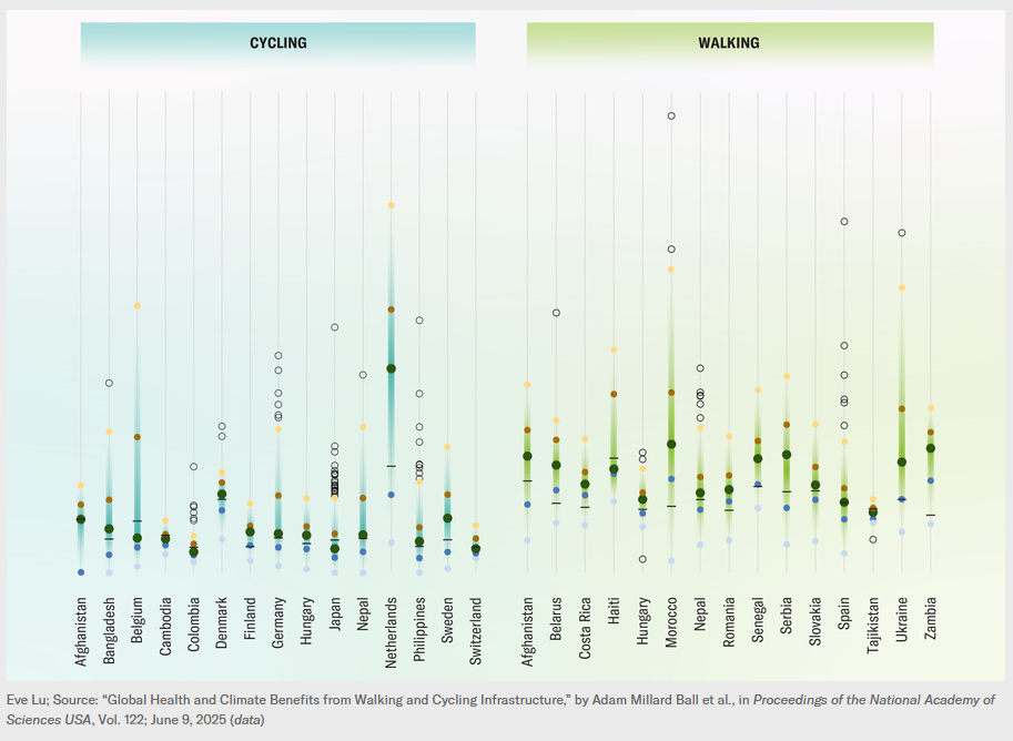 Notable that you needed both carrots and sticks for walking and cycling to thrive, and that infrastructure plays a key role. (It’s not rocket science.)
Blocking the way
Back here in Auckland, Stuff reports:
A road safety sign has been planted in the middle of a cycle lane near a primary school in Auckland, prompting injury concerns and frustration from residents and the local board chair.
Auckland Transport (AT) has acknowledged the positioning is “far from ideal” and says a contractor put it in the wrong spot.
The sign, urging motorists to slow down around a school, went up on Wednesday in the centre of a shared path on Joshua Carder Drive in Scott Point, a new development in Hobsonville in the city’s north-west.
It’s a route heavily used by students walking and cycling to Scott Point Primary. The pole blocks the cycling side of the path, forcing riders to divert around it or move onto the footpath.
 It’s weird how this never happens in the middle of car lanes. Also, on the upside: great to see a chorus of support in the article from residents, local principals, and the Local Board: Hobsonville Point is a bikeable burb in the making!
“Tim Tam” audit shows bike infrastructure is good, actually
An independent audit of the headline-grabbing bike lane separators in New Plymouth, have found the project had significant safety benefits for everyone who uses this stretch of road, which correlates with international research on the subject.
The safe system audit report, conducted by Becca, was due to go before the New Plymouth District Council for consideration on Thursday.
The audit found the $3.8 million project, which was wholly funded by NZ Transport Agency Waka Kotahi, had “created a safety improvement for people who walk, ride and drive” the section of State Highway 45 despite protests from large sections of the community.
Four key findings from the report found the project had significantly improved safety due to reduced speed at intersections, additional crossing points, reduced crossing distances at intersections and the physical separators which were known almost universally as “Tim Tams”.
Despite this, local politicians are still looking into taking them out. In doing so, they’re also ignoring the positive changes seen by schools in the area.
However, schools directly affected by the project reported the changes had provided positive changes with motorists’ habits.
That included West End School principal Hamish Hislop, who believed the changes around the main intersection leading to his school had made it safer for the young students.
Hislop believed the safety improvements were needed given the behaviour of drivers around the school who continued to speed and use their phones at peak times.
“I do not believe removing the safety measures are in the best interests of the students from our school or the ratepayers,” he said.
As always the evidence is clear: what is actually needed is the political bravery to wait for changes to bed in, before rushing to rip stuff out at the slightest squeak of disgruntlement.
Brown’s ideological GPS coming home to roost for Bishop
A story broke this week of Minister of Transport, and MP for Hutt South, using Kāinga Ora money to fund a walking and cycling bridge in his electorate.
Senior minister Chris Bishop used housing money earmarked for a stormwater project to fund a walking and cycling bridge in his electorate – against the advice of his officials.
The $27m in funding from state housing agency Kāinga Ora was needed because the Government’s new transport policy had slashed any funding for non-car infrastructure, documents exclusively obtained by The Post reveal.

As Henry Cooke reports, Bishop signing this off was seemingly against the Cabinet Manual.
It seemingly goes against a Cabinet Manual directive that ministers should not make major decisions about projects within their electorate, but Bishop says making the decision with Finance Minister Nicola Willis was an adequate safeguard.
As Cooke points out, the only reason money needed to be taken from Kāinga Ora, was due to the government’s ridiculously ideological GPS, authored by Simeon Brown.
Bishop, who is both Housing and Transport Minister, had promised to fund the “City Link” bridge between the Melling railway station and Lower Hutt city centre as part of a wider RiverLink project when running to win the Hutt South electorate.
But the Government’s 2024 transport policy statement halved funding for walking and cycling, and introduced severe new restrictions on the money left.
“Investment in walking and cycling should only take place where there is either clear benefit for increasing economic growth or clear benefit for improving safety and where there is an existing or reliably forecast demand for walking or cycling,” the policy statement reads.
This left a $27m deficit in funding for the bridge.
But the Hutt City Council had an idea for where some more public money could be found – an Infrastructure Acceleration Funding agreement between state house developer Kāinga Ora and the council.
The ongoing ramifications of Simeon Brown’s bizarre and petty crusade against walking and cycling continue to spread far outside of just Auckland.
Videos and socials
That’s everything from us this week! Enjoy your weekend.
Share this