
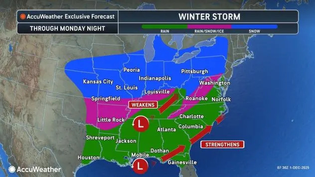
A post-Thanksgiving blitz of winter weather that started with the season’s first significant winter storm in much of the Midwest will continue into the first few days of December, as a new snowstorm takes shape and spans nearly two dozen states from Kansas to Maine, warn AccuWeather meteorologists.
The storm is expected to bring the first widespread accumulating snow of the season to much of the Northeast on Tuesday, just a day after many parts of the Midwest will experience their second covering of snow in as many days.
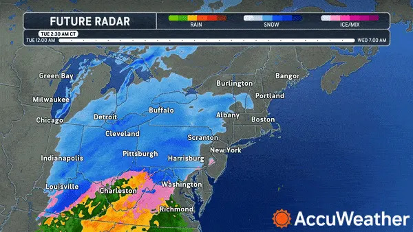
A simulated radar loop from Tuesday morning to Wednesday morning showing the mix of precipitation coming to the Northeast.
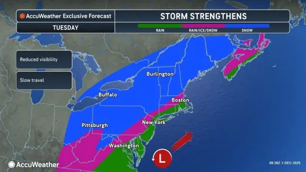
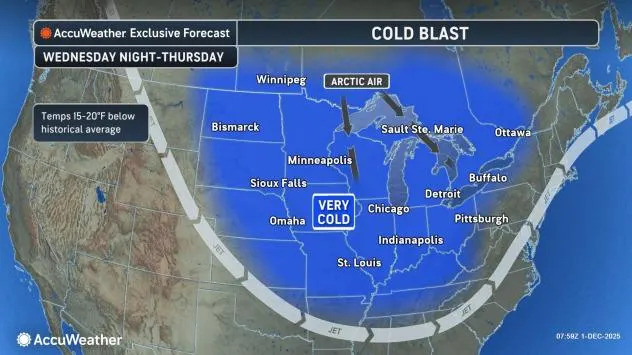
“With cold air entrenched across the Midwest and Great Lakes courtesy of the storm over the weekend, the corridor of snow and ice concerns is expected to shift farther south this week,” said AccuWeather Meteorologist Brandon Buckingham. “It will impact a broad zone from Oklahoma and Arkansas to the Ohio Valley and Northeast.”
Meanwhile, a soaking rain will result in very slow commutes and a risk for flooding on the storm’s warm side, including in many of the big cities along the Interstate 95 corridor in the East.
AccuWeather.com
The messy storm is not expected to be the only one this week in the Midwest and Northeast. AccuWeather winter weather experts are monitoring the possibility of at least one more impacting storm through the first 10 days of December, as cold air will continue to pour in from the Arctic and Canada.
A plowable snow early in the new work and school week
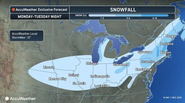
On Monday, snow will expand east across central portions of the Plains and toward the Mississippi Valley, resulting in mostly light accumulations of a few inches and some slippery travel in places like Kansas City and Omaha, Nebraska.
AccuWeather.com
Farther east, an infusion of moisture from the Gulf will take the storm to the next level, as a period of heavy snow will break out by Monday night and Tuesday morning from the eastern Great Lakes and Ohio Valley to the mid-Atlantic and Northeast.
AccuWeather.com
Cities like Cincinnati, Pittsburgh, Harrisburg, Pennsylvania, and Hartford, Connecticut, are expected to experience their first noteworthy accumulating snow of the winter, with the heaviest amounts, likely significant enough to shutter some schools and businesses, coming near a rain/snow battleground.
“The rain versus snow line is expected to come close to the Interstate 95 corridor between Monday night and Tuesday,” said Buckingham. “A slight shift in the storm track farther offshore could help to pull in cold enough air for snow to occur in places like Philadelphia, New York City and Boston.”
AccuWeather.com
Scranton, Pennsylvania; Albany, New York; Worcester, Massachusetts; Concord, New Hampshire; and Bangor and Portland, Maine, were among the cities where higher totals are forecast.
“Just on the other side of the rain/snow line, where the colder air is more dominant, a zone of 3-6 inches of snow is possible across eastern Pennsylvania, upstate New York and across portions of New England,” noted Buckingham.
The fast-moving nature of the storm will save many areas from measuring more than 6 inches, but the AccuWeather Local StormMax™ is 12 inches, and higher snowfall totals are likely to occur inland from the coast in northern or eastern New England, thanks to the storm gaining strength as it moves over the waters of the Atlantic.
AccuWeather.com
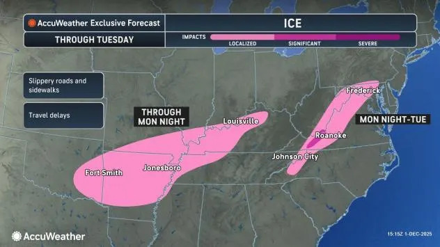
A small area near the rain/snow line can experience ice in the form of sleet or freezing rain for a time as the storm moves through. This is most likely from the Arkansas to a portion of the Mississippi and Ohio valleys, as well as in the eastern Appalachians and the ridge and valley region from western Virginia to southern Pennsylvania.
While any ice accretions are expected to be minimal, any amount of icing can lead to dangerous travel, with slippery roads possible in cities like Little Rock, Arkansas, and Roanoke, Virginia.

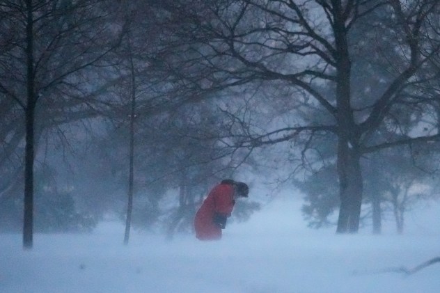
A person walks against the blowing snow Saturday, Nov. 29, 2025, in Chicago. (AP Photo/Kiichiro Sato)
Slow commutes thanks to pouring rain in many big cities
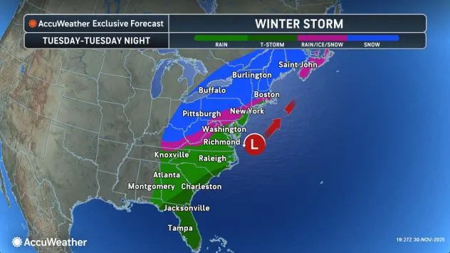
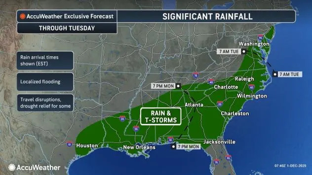
The impending storm will not just result in impactful snow, but also impactful rain for a swath of the South and Eastern Seaboard, warn AccuWeather meteorologists. Multiple commutes, especially on Tuesday along the I-95 corridor from the Carolinas to southern New England, can be slowed by soaking downpours.
AccuWeather.com
While the rain is much needed in many areas, it will be too much of a good thing, too quickly. A fast 1-2 inches of rain can fall from Atlanta to Charlotte to Washington, DC., and Philadelphia with the storm, overwhelming storm drains and leading to ponding on roadways and in low-lying areas.
The Tuesday morning commute can be especially impacted in the mid-Atlantic, where travel times could be doubled due to poor visibility from road spray due to the heavy rain.
Have the app? Unlock AccuWeather Alerts™ with Premium+
Depending on where the rain/snow line sets up in southern New England, the Tuesday evening commute could also be a soggy one there, especially near the coast. Boston will likely toggle back and forth between rain and snow, resulting in a slushy mess.
As quickly as the heavy rain and snow arrive, it will exit by Tuesday night, with high pressure and dry, windy weather returning behind the storm on Wednesday.
More storminess ahead by the weekend
The current active and wintry weather pattern will not end with the early-week storm. AccuWeather’s team of long-range experts, led by Paul Pastelok, is warning that the better part of the first two weeks of the month will remain cold and stormy across much of the central and eastern parts of the nation, thanks to a southward shift in the polar vortex.
AccuWeather.com
Another storm, which was still located over the Pacific Ocean as of Sunday, will cross the country and gather energy and moisture before bringing another round of snow and ice to much of the Midwest and East late in the week and into the new weekend.
While the exact details and timing of this storm remain to be seen, it appears yet another round of accumulating snow will fall in places such as Cleveland, Chicago, Detroit and Pittsburgh, and perhaps even close to the big cities in the Northeast.
The snow and ice can even occur in two phases, depending on how the weather pattern unfolds into the second week of December.
Earlier this year, AccuWeather’s winter forecast called for colder weather to take hold early in the season, in December. It also indicated snowfall for the entire season would likely end up above the historical average for swaths of the Midwest, but below average in the East.
Want next-level safety, ad-free? Unlock advanced, hyperlocal severe weather alerts when you subscribe to Premium+ on the AccuWeather app. AccuWeather Alerts™ are prompted by our expert meteorologists who monitor and analyze dangerous weather risks 24/7 to keep you and your family safer.