
After months of public battling, Indiana House Republicans have shared their proposal for a new congressional map for Indiana.
INDIANAPOLIS — Indiana House Republicans have released a proposed new congressional map for the state, as part of President Donald Trump’s redistricting push.
The new map redraws every one of Indiana’s nine congressional districts. The goal is make it so every district is held by a Republican. Currently, seven districts are held by Republicans, and two are held by Democrats.
The map was first posted on the Indiana House Republicans website. The bill to make the map law, was introduced in the Indiana House.
The map seeks to unseat Rep. André Carson (D-Indianapolis) and Rep. Frank Mrvan (D-Gary), the two Democrats in the Indiana congressional delegation.
Carson issued a statement shortly after the map was released:
“Hoosier values matter more than DC threats and bullying. Splicing our state’s largest city—and its biggest economic driver—into four parts is ridiculous. It’s clear these orders are coming from Washington, and they clearly don’t know the first thing about our community. Hoosiers have made their voices heard and won’t stand for it.”
Bill attempts to block legal challenges
The language of the redistricting bill, authored by Rep. Ben Smaltz (R-Auburn), includes several clauses that seem meant to prevent legal challenges to the bill.
In addition to laying out the new congressional districts, the bill says that only “the supreme court” can rule against maps passed by state lawmakers. As this is state law, this means the Supreme Court of Indiana.
The bill says there can be no temporary injunctions against the map, and that no lower court can rule in favor of an appeal. Any ruling a lower court might make would be automatically stayed “pending disposition of the appeal by the supreme court.”
The bill also says “any action or appeal of an action to which this section applies must be given priority over ordinary matters.”
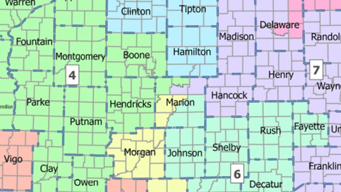
What does the bill change?
In addition to restricting which courts can block congressional maps, the bill also redraws the current ones.
Under the current Indiana congressional maps, most of Marion County is in District 7. Under the proposed map, the county would be divided between the 4th, 6th, 7th and 9th districts.
The 9th District would stretch from the Ohio River before snaking through Brown and Morgan counties before snaking into downtown Indianapolis.
The 7th District would contain just the northeastern corner of the county before moving to cover a variety of counties on the east-central part of the state including Hancock, Madison, parts of Delaware, Henry, Randolph and Wayne counties.
The 6th District would cover the southeastern portion of Marion County and Johnson, Shelby, Bartholomew, Rush, Fayette, Decatur and Jennings counties.
The 4th District would include the northwestern corner of Marion County, along with a slew of counties stretching to the Illinois border and from Greene County all the way up to Jasper County. Much of the northern portion of that district is currently in District 1.
Where does the bill stand?
House bill 1032 was introduced on Monday, Dec. 1. It was assigned to the Elections and Apportionment committee in the House, chaired by Rep. Tim Wesco (R-Elkhart). Smaltz, who authored the bill, is also on the committee.
If passed by the committee, the bill would move to the full House. If passed, it would then head to the Senate for a similar if likely more difficult path.
This is a breaking news story and will be updated as new information becomes available.