
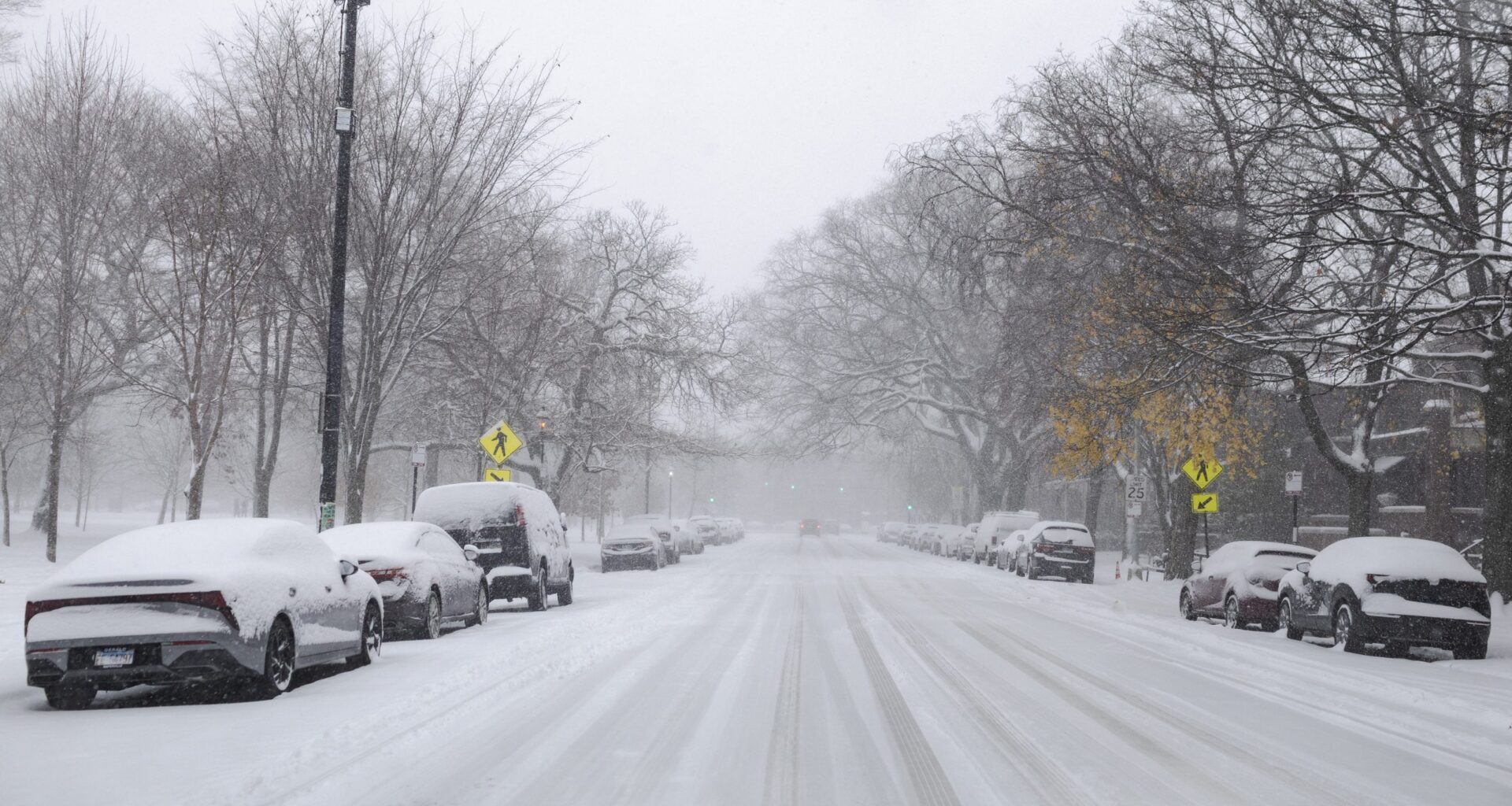
CHICAGO — Chicagoans can expect a few more inches of snow Monday followed by bitter cold throughout the week, according to the National Weather Service.
After seeing its snowiest November day ever Saturday, Chicago is expected to get 2-4 more inches of accumulation Monday, the National Weather Service’s forecast states.
The agency issued a winter weather advisory from 2 p.m. through midnight. Chicagoans can expect slippery road conditions and “hazardous conditions” including reduced visibility, with high temperatures only hitting 25-30 degrees and low temperatures falling to 11-21 degrees.
“We have a snow shower that’s currently pushing into the Midwest right now … that should make its way over Chicagoland here in the next several hours or so,” meteorologist Kevin Doom said Monday morning. “We’re pretty much going to see some steady, light, at times moderate snowfall through the rest of the evening.”
The snow is expected to let up around midnight, Doom said. But there will be “bitter cold” from a cold front hitting later this week, he said.
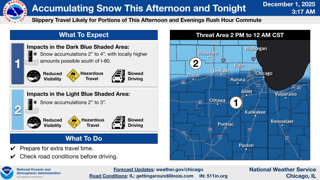 Chicagoans can expect hazardous driving conditions Monday, according to the National Weather Service. Credit: National Weather Service
Temperatures are expected to drop through Thursday. Tuesday will have lows of 14-19 degrees and Wednesday’s lows are expected to be 6 below zero to 12 degrees, according to the National Weather Service.
Thursday is forecasted to be the coldest day of the week, with lows of 8 below zero possible and highs of 8-19 degrees.
RELATED: Here’s How To Stay Warm And Safe When Extreme Cold Hits Chicago
“Even during the warmest part of the day, the wind chill is going to be barely above zero,” Doom said. “So it’s going to be a bit of a cold day on Thursday. … It won’t last too long. It’ll warm up as we gradually trend back toward normal as we head towards the weekend.”
Chicagoans should “bundle up from head to toe” if they’re outside and should avoid unnecessary travel through the snow and freezing temperatures, Doom said.
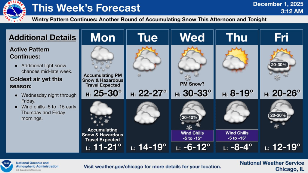 The weather forecast for Dec. 1-5 from the National Weather Service. Credit: National Weather Service
RELATED: Here’s How To Get Your Car Ready For Snowy Chicago Winters
The National Weather Service also recommends these safety tips:
Take precautions to “winterize” vehicles and have necessary supplies on the go.
Know and pay attention to signs of frostbite, including redness or pain in the skin can be a sign frostbite is beginning; numbness; white or grayish-yellow skin; and skin that feels unusually firm or waxy, according to the The Centers for Disease Control and Prevention. More information about frostbite is online. People experiencing these symptoms should seek immediate medical attention.
Know and pay attention to signs of hypothermia, including shivering, exhaustion, confusion, fumbling hands, memory loss, slurred speech, drowsiness and bright, cold skin and very low energy in babies. People experiencing these symptoms should seek immediate medical attention.
Avoid unnecessary trips outside. If you have to go outside, limit time spent outside.
Wear several layers of loose, warm clothing if you must go outside.
Stay dry because moisture can damage the insulation effectiveness of clothing.
Sign up for lakefront notices from the city’s Office of Emergency Management and Communications by texting “CHILAKE” to 78015.
Sign up for issues affecting business or events by texting “CHIBIZ” to 67283
Chicagoans can stay updated about weather-related news on the city’s website. They can also sign up for weather, traffic and other emergency alerts at notifychicago.org.
Listen to the Block Club Chicago podcast: