
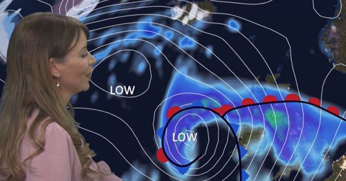
It says a powerful jet stream will continue to drive weather into next week and may help to rapidly deepen an area of low pressure that will bring heavy rain and high winds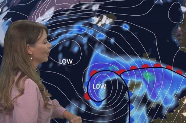 Wales is bracing itself for widespread downpours(Image: BBC Weather)
Met Office weather maps have shown the huge area of low pressure heading to Wales as the country braces itself for widespread downpours and high winds. The meteorological service says that a powerful jet stream will continue to drive weather into next week and may help to rapidly deepen an area of low pressure later on Monday and into Tuesday.
It comes as a yellow weather warning for rain has been issued for Wales on Monday and Tuesday with 16 areas of the country covered.
The 24-hour warning is affecting Blaenau Gwent, Bridgend, Caerphilly, Cardiff, Carmarthenshire, Ceredigion, Merthyr Tydfil, Monmouthshire, Neath Port Talbot, Newport, Pembrokeshire, Powys, Rhondda Cynon Taf, Swansea. Torfaen and Vale of Glamorgan.
Here’s what we can expect on Monday night and into Tuesday.
Monday
7.30pm
 7.30pm on Monday(Image: Met Office)
Rain will begin to impact areas of Wales at 7.30pm, with parts of Cardiff first affected.
9pm
 Rain will begin to affect Wales from 9pm Monday(Image: Met Office)
By 9pm, Pembrokeshire and Swansea will be affected, with downpours of 4-8mm per hour.
11pm
 At 11pm, rainfall will cover most of the country(Image: Met Office)
Most of the country will be affected by 11pm, with small areas of Swansea and Pembroke to experience 8-16mm per hour.
Midnight
 How it will look at midnight(Image: Met Office)
Rain will become heavier and more widespread in several parts of the country by midnight.
Tuesday
1am
 The forecast for 1am on Tuesday(Image: Met Office)
At 1am, large swathes of Swansea will experience 8-16mm per hour downpours.
8am
 Rain will still cover most of Wales at 8am(Image: Met Office)
Rain will still blanket most of Wales at 8am, but will be lighter than through the night.
Noon
 Tuesday at noon(Image: Met Office)
Pembroke will be largely dry by noon, as rain dissipates.
3pm
 How it will look at 3pm on Tuesday(Image: Met Office)
At 3pm, rain will have cleared.
The Met Office has three categories of weather warning, depending on the likely impact of severe weather and also how likely it is to strike in a particular area.
A yellow warning is issued when weather conditions are expected to disrupt travel and traffic and may impact on daily routines but are not likely to pose a risk to life or property.
Content cannot be displayed without consent
An amber warning is more severe and advises people to think about changing their plans to minimise the risk.
A red warning means weather conditions are expected to be dangerous with widespread damage to property and a risk to life, with the public usually advised to avoid travelling.
The Met Office forecast for Wales says: “A widely fine and dry day on Monday, though often breezy with occasional heavy showers. Turning increasingly cloudy with strengthening winds overnight as a band of heavy rain spreads northeastwards. Maximum temperature 10 °C.”
It adds: “Heavy rain and strong winds on Tuesday, with gales possible, though some brighter spells through the afternoon. Wednesday brings occasional showers and sunny spells, before turning briefly settled on Thursday.”