
A ‘danger to life’ amber rain warning has been issued for parts of Wales as Storm Bran brings heavy rain and strong winds to Wales The first weather warning comes into force at 6pm on Monday(Image: Met Office)
Wales is set for some disruptive weather over the next 24 hours as Storm Bram rolls in. The Met Office has issued three separate weather warnings covering large parts of Wales on Monday evening (December 8) and for much of Tuesday (December 9).
Yellow weather warnings for both wind and rain were issued on Sunday afternoon but the forecaster issued an upgraded “danger to life” warning for parts of south and mid Wales on Monday due to the forecasted downpours. The parts of Wales affected by this warning, which is in force from midnight until 10am include: Blaenau Gwent, Bridgend, Caerphilly, Carmarthenshire, Merthyr Tydfil, Monmouthshire, Neath Port Talbot, Powys, Rhondda Cynon Taf, Swansea and Torfaen.
Forecasters say that within the warning zone, fast-flowing or deep floodwater is likely, along with the risk of landslides on already saturated slopes. Rainfall could reach 20-40 mm widely, with 60-80 mm in hilly areas — and in some upland regions, totals could soar to 100–120 mm.
From 6pm on Monday, there is a 24-hour yellow weather warning for rain which will be in force for most of the country. Western parts of Wales are also covered by a yellow wind warning which will come into place at 10pm. The alert covers Carmarthenshire, Ceredigion, Conwy, Denbighshire, Gwynedd, Isle of Anglesey, Pembrokeshire, Powys and Swansea.
Weather maps show that gusts may be stronger than 60mph in some coastal areas. Here is the hour-by-hour forecast which shows which areas will be worst affected:
Monday, December 8
6pm
 (Image: Met Office)
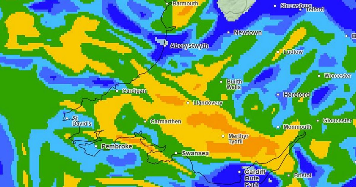
The 24-hour rain warning affecting Blaenau Gwent, Bridgend, Caerphilly, Cardiff, Carmarthenshire, Ceredigion, Merthyr Tydfil, Monmouthshire, Neath Port Talbot, Newport, Pembrokeshire, Powys, Rhondda Cynon Taf, Swansea, Torfaen and Vale of Glamorgan comes into force at 6pm. At this time, there will be some prolonged showers in parts of the country, while other areas will remain dry until later on.
8pm
 (Image: Met Office )
The worst of the weather is due to arrive later on Monday evening. For the biggest stories in Wales first, sign up to our daily newsletter here
10pm
 (Image: Met Office )
By 10pm, the heavy downpours will start to roll in across south Wales.
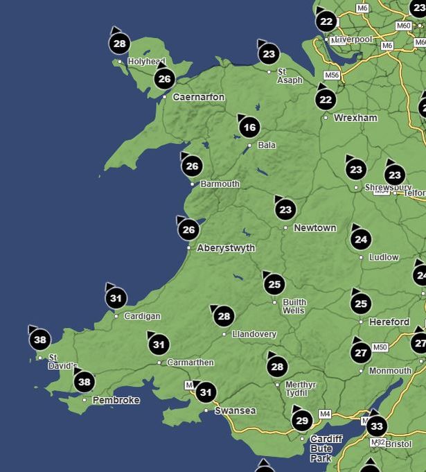
The wind warning comes into force at 10pm, with gusts soon rising above 40mph along the west coast.
Midnight
By midnight, most of the country will be covered by a heavy band of rain. Much of south and west Wales will see heavy downpours with between 4-8mm of rain falling each other, reaching up to 16mm in some areas.
Tuesday, December 9
3am
 (Image: Met Office )
The downpours will continue to get heavier overnight.
 (Image: Met Office )
Wind speeds will also continue to increase, reaching gusts of over 50mph in coastal regions.
6am
 (Image: Met Office)
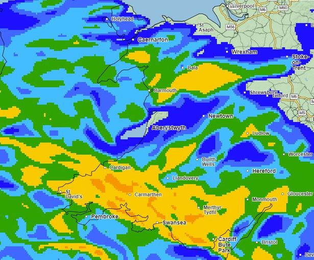
Most of the country will be waking up to heavy rainfall on Tuesday morning.
 (Image: Met Office )
By 6am, gusts are forecast to reach 60mph in St David’s.
9am
 (Image: Met Office )
The persistent downpours are set to continue for much of Tuesday morning.
 (Image: Met Office)
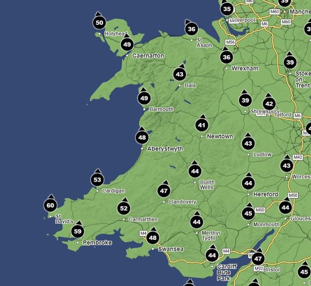
The wind is set to get stronger throughout the morning. At 9am, gusts of up to 65mph are forecast for the north and west coasts of Wales. Holyhead is expected to see 64mph winds.
Midday
 (Image: Met Office)
By midday the worst of the downpours will have passed but there will still be rainfall across much of the country.
 (Image: Met Office)
Gusts above 65mph have been forecast for midday on Tuesday
2pm
 (Image: Met Office)
The rain will start to ease off from 2pm.
4pm
 (Image: Met Office)
The yellow wind warning ends at 4pm. Strong gusts above 50mph are forecast at this time, before wind speeds drop off throughout the evening.
6pm
 (Image: Met Office)
The heavy rain will have eased by 6pm when the warning comes to an end. It’s due to remain dry on Wednesday with scattered heavy showers until further heavy downpours later in the week.
Get daily breaking news updates on your phone by joining our WhatsApp community here. We occasionally treat members to special offers, promotions and ads from us and our partners. See our Privacy Notice