
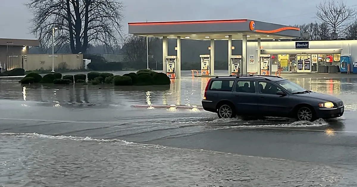
Record flooding is set to continue sweeping across Western Washington on Thursday, with much of the fury centered on two of the state’s mightiest rivers: the Snohomish and the Skagit.
Skagit County officials ordered “GO NOW” evacuations for the entire 100-year flood plain of the Skagit River valley. About 100,000 people were expected to be evacuated statewide, Gov. Bob Ferguson’s office said.
The National Weather Service said river flooding in parts of the region is expected to be “catastrophic.” A flash flood watch remains in effect through late Friday for a potential levee failure of the Skagit River below Sedro-Woolley.
Check this page throughout Thursday for the latest information on evacuations, closures, forecasts, river water levels and more. We’ll also have resources for those bracing for the floods.
As Skagit swells, Mount Vernon woman fears for 68 miniature donkeys
West of Mount Vernon, where residents have been issued orders to evacuate immediately because of “catastrophic” flooding forecast by the National Weather Service, Julie Jones was waiting, fretting about what to do with her 68 miniature donkeys.
Yes, 68 miniature donkeys.
“I’m one of the top miniature donkey farms in the world,” Jones said Wednesday.
—Greg Kim
King County road closures
—Fareeha Rehman
Snohomish River rises to record-breaking levels in Snohomish
The Snohomish River at Snohomish rose Thursday morning to its highest water level in 35 years.
The river reached a preliminary 33.57 feet at 6 a.m., according to the National Weather Service, just slightly over the record 33.5 feet set in November 1990.
The weather service forecasts the river to begin receding, but warned flood waters will likely overtop levees and inundate much of the river valley, including Highway 2 west of Monroe.
—Paige Cornwell
Evacuations in Skagit, Whatcom, Snohomish, Pierce counties
Counties throughout Western Washington have issued immediate orders to evacuate as catastrophic floodwaters threaten riverside and low-lying communities Thursday.
An estimated 100,000 Washington residents could face evacuation orders because of rapidly rising floodwaters, Gov. Bob Ferguson’s office said Wednesday afternoon.
Numerous communities in Skagit County on the 100-year flood plain were told to “GO NOW” under a level three evacuation order Wednesday. That area includes Burlington, La Conner, Lyman, Hamilton, parts of Mount Vernon and Sedro-Wooley, and areas along the Skagit River.
—Kai Uyehara
Portions of I-90, Highways 2, 18, 20 closed
Portions of Interstate 90, other major highways and local roads are closed Thursday morning throughout Western Washington because of flooding and mudslides.
Eastbound Interstate 90 near North Bend remains closed because of a mudslide. The interstate is closed for 5 miles from Winery Road to 436th Avenue Southeast.
Law enforcement is directing traffic through the area because there is water on the roadway, according to the Washington State Department of Transportation.
—Paige Cornwell
Nearly 16 inches of rain over 3 days in some parts of WA
How much rain did the atmospheric river dump on Western Washington so far?
In some parts of the state, the total over three days was well over a foot of rain, according to the National Weather Service as of 5 a.m. Thursday.
Most of the higher totals were seen in the mountains, with 15.6 inches in the Cascades south of Interstate 90 and 14 inches in Mount Rainier National Park over 72 hours, the weather service’s rainfall map shows.
Seattle and its surrounding cities saw 1 to 4 inches of rain.
—Fareeha Rehman
WA school delays, closures
—Claire Withycombe
Western WA saw almost 5 trillion gallons of rainfall
Warm water and air and unusual weather conditions tracing back as far as tropical cyclone flooding in Indonesia helped supercharge stubborn atmospheric rivers that have drenched Washington state with almost 5 trillion gallons of rain in the past seven days, threatening record flood levels, meteorologists said.
The worst and most persistent of the heavy rains will linger to douse the same location through late Thursday and early Friday morning before the river of moisture should lessen and move around a bit. But the West Coast likely won’t see an end to the “fire hose” of moisture until the week of Christmas, said Matt Jeglum, acting science chief for the National Weather Service’s western region.
—Seth Borenstein, The Associated Press
Mudslide closes Highway 18
Highway 18 from Interstate 90 to Issaquah-Hobart Road is closed because of a mudslide, Washington State Patrol Trooper Rick Johnson posted on X shortly after 6 a.m. Wednesday.
#ClosureAlert SR 18 is fully closed at I-90 and the Issaquah/Hobart Road for a mudslide. More details to come.
— Trooper Rick Johnson (@wspd2pio) December 11, 2025
—Seattle Times staff
Dozens of Snohomish County road closures
Several roads in Snohomish County are closed overnight into Thursday morning due to flooded roads.
A map provided by the county showed clusters of closures stretching from Stanwood to Silvana; Everett to Snohomish; and in Monroe near the Skykomish River as of 6:30 a.m.
Floodwaters are often much deeper than they appear, the Snohomish County sheriff’s office warns.
—Fareeha Rehman
Catch up with what happened Wednesday
Western Washington residents along the Skagit and Snohomish rivers could face “catastrophic” and life-threatening flooding Thursday from the week’s heavy rainfall, National Weather Service officials said.
Officials ordered evacuations for parts of Orting in Pierce County, Ebey Island in Snohomish County and Skagit County in the 100-year floodplain.
An estimated 100,000 Washington residents could face evacuation orders because of rapidly rising floodwaters, Gov. Bob Ferguson’s office said Wednesday afternoon.
Ferguson declared a state of emergency and said he would request federal funding to assist in flood recovery. He thanked first responders and issued a plea for the public: “If you receive an evacuation order, please, please follow that order. It is critical for your safety.”
—Seattle Times staff
Where to find weather shelters, emergency information
As historic flooding sweeps Western Washington, here are some tips and resources for evacuations, signing up for alerts and finding shelter.
What do I do if I need to evacuate?
The American Red Cross recommends the following:
Gather all necessary medications and important documents.
Get to higher ground as soon as you can.
Compile an emergency kit with up to three days’ worth of supplies if you can.
Follow evacuation routes and don’t attempt shortcuts.
Avoid driving or walking through floodwaters.
Make a plan on how to reconnect with family if you are separated.
When safe, sign up for emergency alerts from your local government.
How do I sign up for alerts and learn more about emergency preparedness?
You may be able to sign up for alerts and find emergency preparedness information through your county’s website:
Where can I find shelter?
The American Red Cross has an interactive map with shelter locations. The shelters listed as of 7 p.m. Wednesday are:
Bethany Covenant Church, 1318 S 18th St, Mount Vernon, WA 98274
Meridian Habitat Park, 14422 Meridian Ave E., Puyallup, WA 98375
New Community Church, 21401 244th Ave SE, Maple Valley, WA 98038
Packwood Community Hall, 12935 US 12, Randle, WA 98377
St. John’s Lutheran Church, 2190 Jackson Hwy, Chehalis, WA 98532
Your local city or county government may have information on other shelters. King County Regional Homelessness Authority activated its “severe weather” protocols through the weekend and lists more resources on its website.
—Caitlyn Freeman
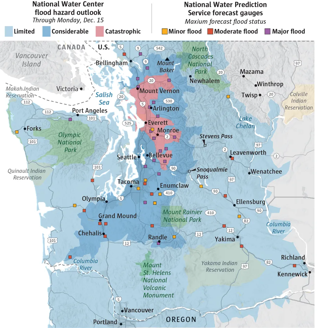
Where ‘catastrophic’ flooding is expected
River flooding in parts of Western Washington is expected to be “catastrophic,” especially in the coastal lowlands near the Snohomish, Stillaguamish and Skagit rivers, according to a new assessment by the National Weather Service.
Areas facing “considerable” flooding stretch from Bellingham through south of Olympia.
“Catastrophic” flooding is expected from Mount Vernon through Everett and into areas east of Redmond.
‘Catastrophic‘ flooding areas
Severe flooding is expected from Mount Vernon through Everett and into areas east of Redmond.
—Greg Kim
‘Go Now’ ordered for all of Skagit floodplain ahead of historic flood
As unrelenting rains fell Wednesday morning across Western Washington, with a forecast for much more in the hours ahead, Mount Vernon Mayor Peter Donovan braced for the worst.
A more severe flood than any other in recent memory could inundate the region if forecasts hold. Even as crews set up a downtown floodwall along the banks of the Skagit River, meteorologists predict the waters could climb over the barrier.
“We are currently preparing for what appears to be a potentially worst-case scenario, which is a massive flood event for Skagit County,” Donovan said.
The city began evacuating some neighborhoods Wednesday evening. By night, county officials had ordered “GO NOW” evacuations for the entire 100-year floodplain of the Skagit River valley — the county’s main population center.
—Isabella Breda and Conrad Swanson