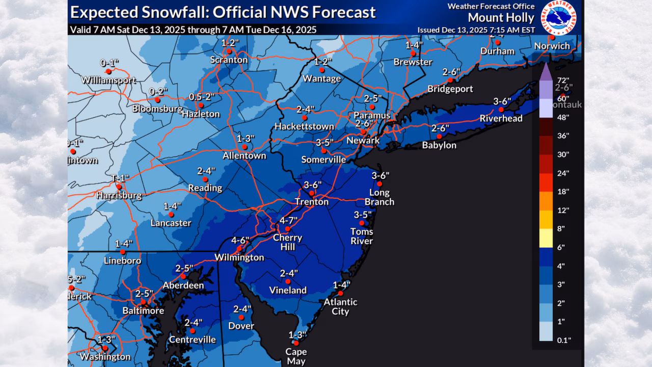
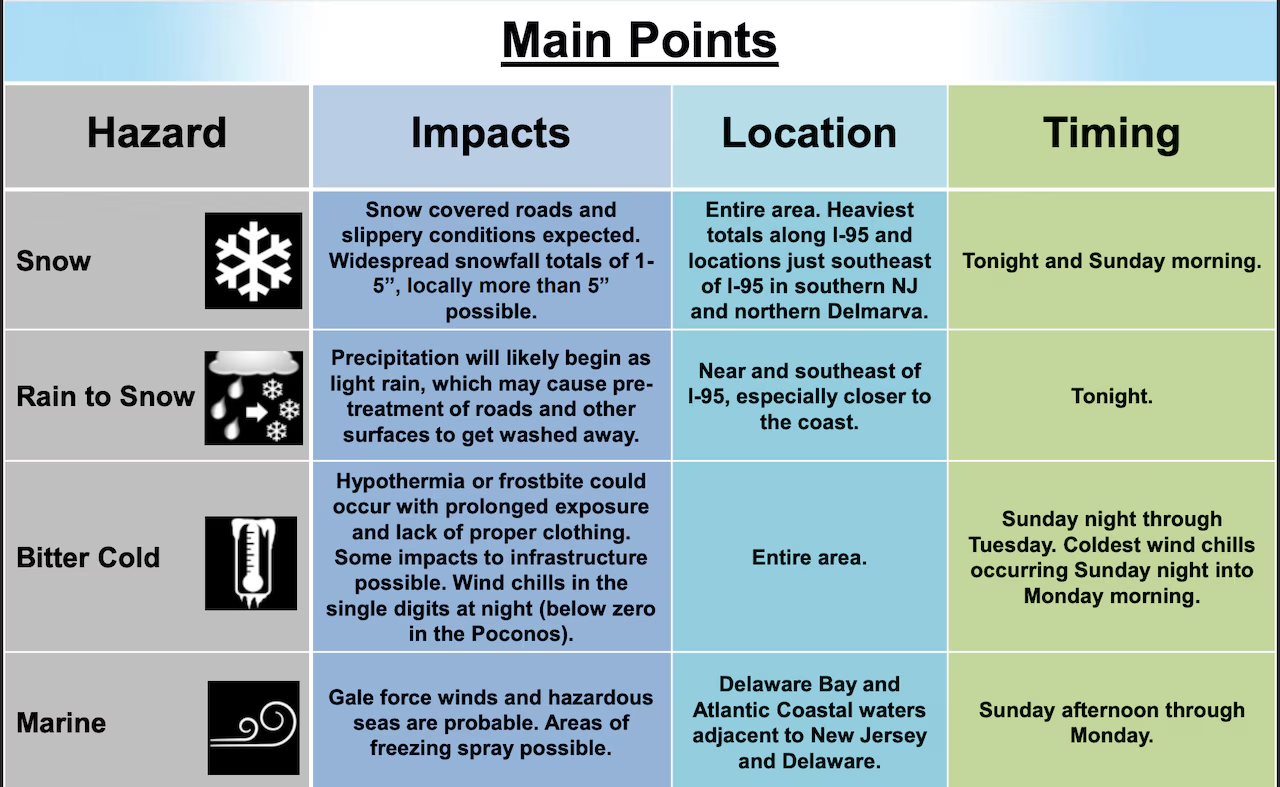
Snowfall total forecasts for a winter storm expected to hit New Jersey tonight have increased to 5+ inches in some areas with winter weather advisories now expanded to 19 counties.
The National Weather Service’s latest forecast calls for “1-5 inches of snow across the entire region, with a zone of 5+ inches possible.”
The highest snowfall totals are likely in a wide band through southern and central New Jersey, the weather service said in an update early Saturday.
“While the location of any 5+ inch amounts is less certain, the greatest chance for this is across the I-95 corridor and immediately to the southeast in southern N.J.,” the weather service said.
Even the Jersey Shore should expect to see a few inches of snow.
 The National Weather Service has increased the forecast for snow to more than 5 inches in some parts of New Jersey from a winter storm tonight into Sunday morning. Dangerously cold temperatures and gusty winds will follow the storm and continue through Monday.National Weather Service
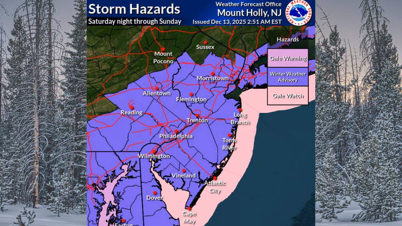
Winter weather advisories are in effect for most of New Jersey from 7 p.m. Saturday through 1 p.m. Sunday. Just Sussex and Passaic counties, where 1 to 2 inches of snow is expected, are excluded from the advisory.
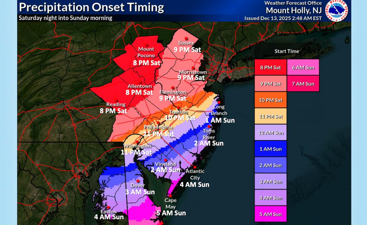
The heaviest snow will fall after midnight Saturday night into Sunday morning.
 The National Weather Service has increased the forecast for snow to more than 5 inches in some parts of New Jersey from a winter storm tonight into Sunday morning. Dangerously cold temperatures and gusty winds will follow the storm and continue through Monday.National Weather Service
Precipitation may start as rain along and southeast of Interstate 95 before transitioning to snow late Saturday evening into the overnight hours.
Areas north of Interstate 78 and west of Interstate 287 will see snow from the start, with accumulations of 2 to 4 inches expected.
Areas along and southeast of I-95 can expect 3 to 5 inches of snow.
 The National Weather Service has increased the forecast for snow to more than 5 inches in some parts of New Jersey from a winter storm tonight into Sunday morning. Dangerously cold temperatures and gusty winds will follow the storm and continue through Monday.National Weather Service
The National Weather Service warns that untreated surfaces will become slippery, particularly from late evening through mid-morning Sunday.
The snow should taper off from northwest to southeast Sunday morning, ending by around noon.
Some spotty snow showers may continue into Sunday afternoon.
 The National Weather Service has increased the forecast for snow to more than 5 inches in some parts of New Jersey from a winter storm tonight into Sunday morning. Dangerously cold temperatures and gusty winds will follow the storm and continue through Monday.National Weather Service
Wind gusts up to 30 mph are possible after the storm and could cause some blowing and drifting snow.
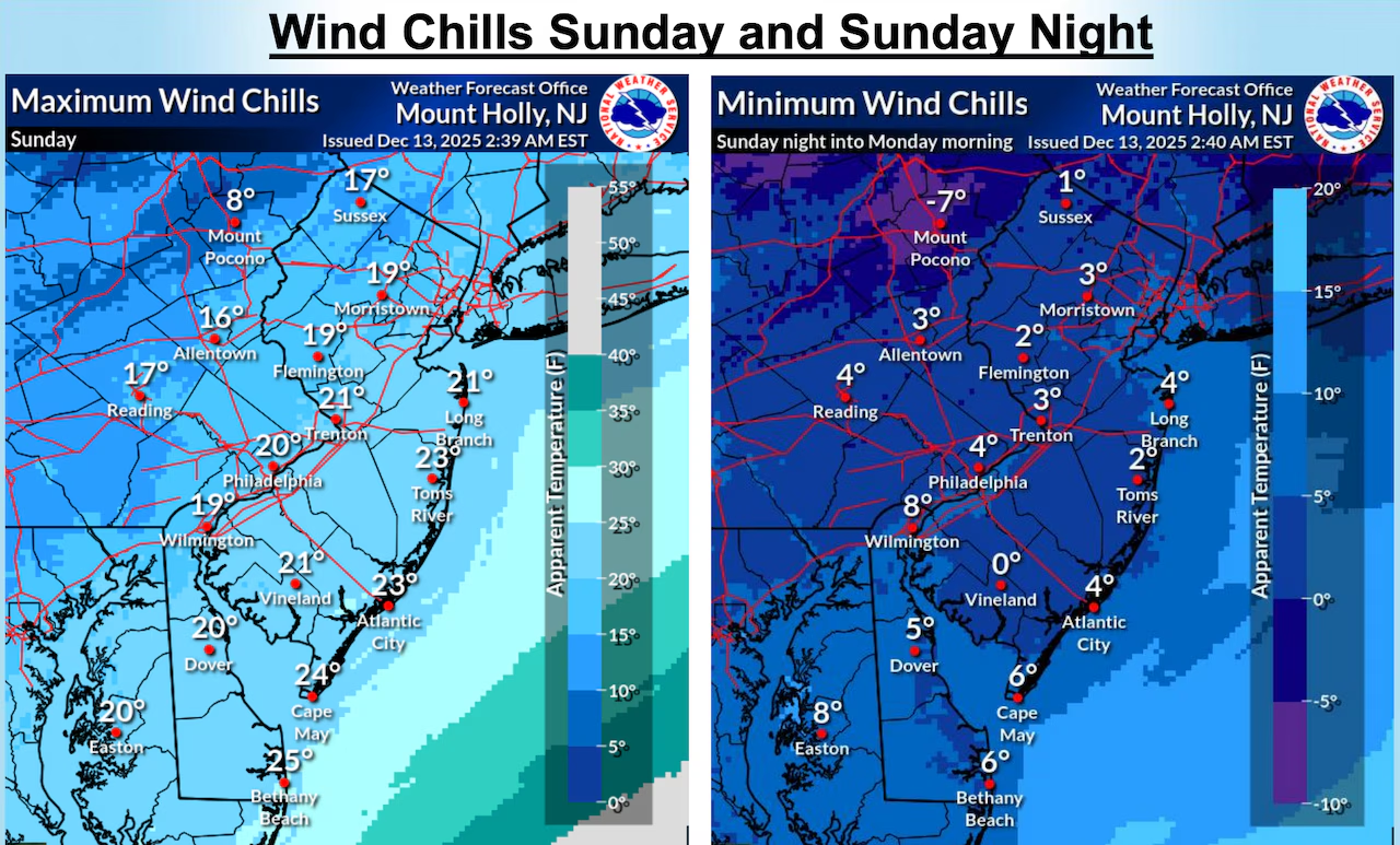
Arctic air will surge into New Jersey Sunday night, bringing bitterly cold conditions.
Wind chill values will drop into the single digits for most areas Sunday night into Monday morning, with some locations possibly reaching below zero.
Winds will gust between 25 and 35 mph Sunday night, gradually decreasing Monday.
 The National Weather Service has increased the forecast for snow to more than 5 inches in some parts of New Jersey from a winter storm tonight into Sunday morning. Dangerously cold temperatures and gusty winds will follow the storm and continue through Monday.National Weather Service
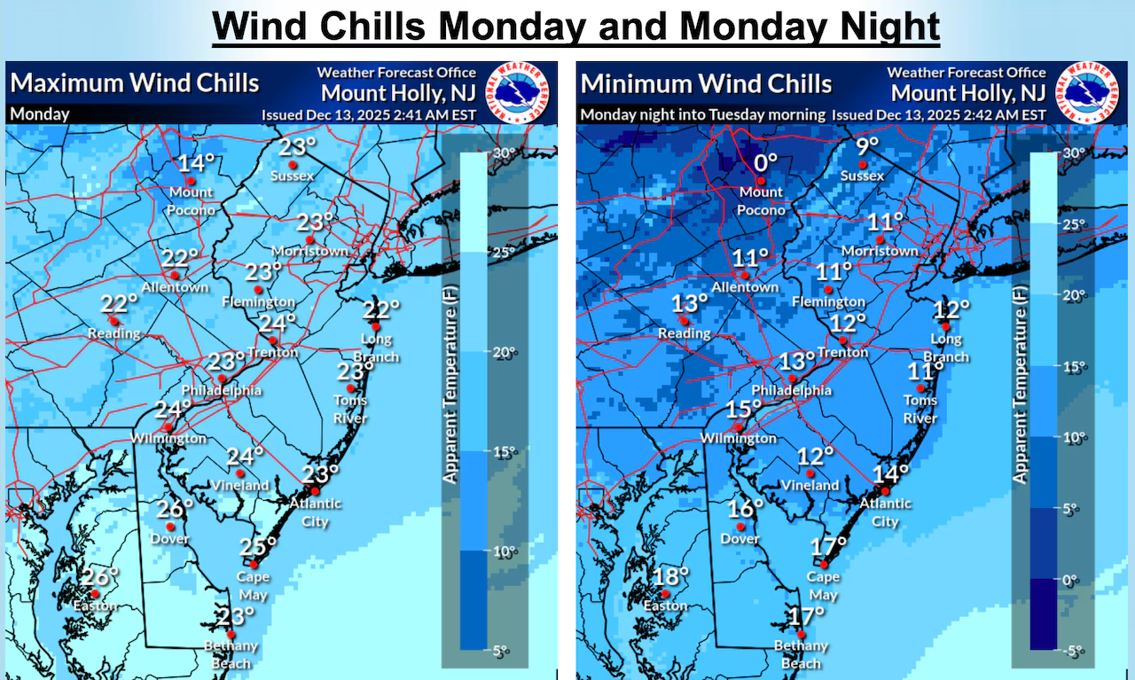
High temperatures Monday will only reach the low to mid 30s for most areas, with the higher elevations in the 20s, well below normal for mid-December.
The cold snap continues Monday night with temperatures in the teens for many areas and winds of 5 to 10 mph, resulting in wind chill values in the low to mid teens.
Tuesday remains dry with high pressure in place across the region, with highs in the mid 20s to mid 30s.
Tuesday night stays cold with overnight lows in the 20s for most areas and teens for higher elevations.
A warming trend begins Wednesday with high temperatures in the upper 30s to upper 40s.
The warmup continues Thursday with temperatures climbing to the upper 40s to upper 50s.
A cold front will bring a chance of rain Thursday into Thursday night before high pressure builds back in for Friday, when temperatures return to the 40s for most areas.
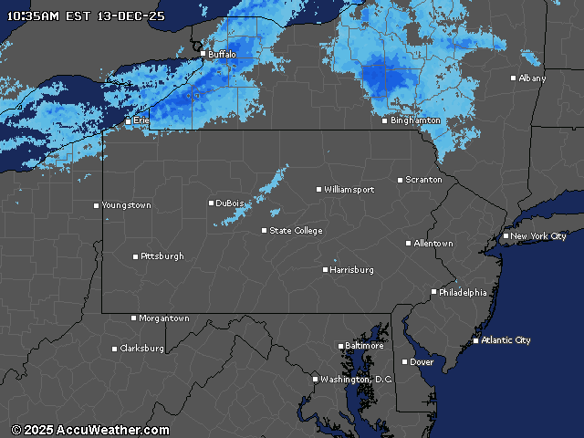
Current weather radar