
UPDATE 1:54 p.m.: Parts of Northeast Ohio are now under a lake-effect snow warning, while a winter weather advisory has been issued for the rest of the region.
###
CLEVELAND, Ohio — If you have holiday shopping or weekend plans in Northeast Ohio, you’ll want to keep a close eye on the weather, with accumulating snow expected Saturday and Sunday and a surge of Arctic air bringing dangerously cold wind chills.
Quiet conditions to end the workweek will give way to an increasingly wintry pattern this weekend, as snow spreads across the region Saturday and lingers into Sunday before bitter cold settles in behind it.
Forecasters with the National Weather Service in Cleveland say travel could become difficult at times, especially in the snowbelt, where the heaviest snow is expected.
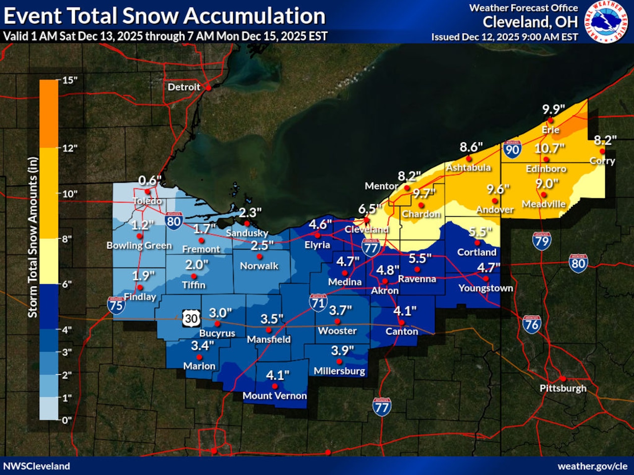
A winter storm watch is in effect from 7 a.m. Saturday through 1 a.m. Monday for portions of Northeast Ohio, including Cuyahoga, Lake, Geauga and Ashtabula counties, where heavy lake-effect snow could lead to significant accumulations.
Forecasters say 6 inches or more of snow is possible in the most persistent bands from a passing weather system and lake-effect snow, with gusty winds up to 30 to 35 mph potentially causing blowing snow and reduced visibility.
Snow develops Saturday, intensifies in snowbelt areas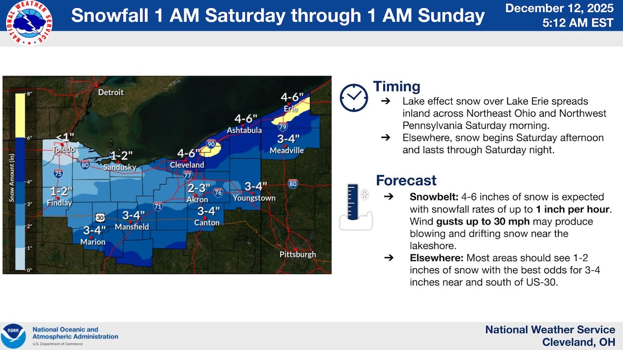 Lake-effect snow develops Saturday, with the highest totals along the lakeshore in Northeast Ohio. The snowbelt could see 4 to 6 inches, while most other areas pick up 1 to 4 inches as a clipper system moves through. Snowfall rates up to 1 inch per hour and gusty winds may reduce visibility, according to forecasters.Courtesy National Weather Service
Snow chances will increase early Saturday as a cold front moves through Northeast Ohio, bringing scattered, generally light snow showers to start the day.
The main round of accumulating snow will arrive later Saturday as a fast-moving clipper system pushes in from the west, spreading snow across much of the region from late morning through the afternoon and evening. This period is expected to produce the most widespread snowfall, including areas outside the snowbelt.
As the clipper system exits Saturday night, much colder air will pour in, shifting the focus to lake-effect snow that continues into Sunday.
Most communities can expect 1 to 4 inches of snow by Saturday night, while snowbelt areas — especially east of Cleveland — could see 4 to 6 inches, with locally higher totals where snow bands persist.
During the afternoon and evening, snowfall rates may briefly approach 1 inch per hour, and gusty winds could reduce visibility at times, making travel hazardous.
Lake-effect snow continues Sunday as Arctic air arrives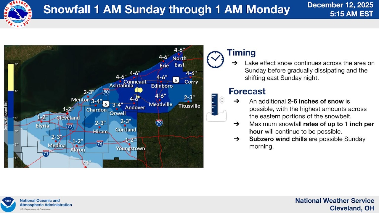 Lake effect snow continues Sunday before gradually shifting east and weakening Sunday night. An additional 2 to 6 inches is possible in the snowbelt, especially in areas east of Cleveland. Frigid wind chills are expected Sunday morning, as well.Courtesy National Weather Service
Lake-effect snow is expected to continue into Sunday, focusing on snowbelt areas as winds remain favorable for bands to come ashore from Lake Erie. An additional 2 to 6 inches of snow is possible in those locations through Sunday night.
Outside of the snowbelt, snow chances will diminish Sunday as high pressure gradually builds in, but the cold will remain firmly in place.
Subzero wind chills possible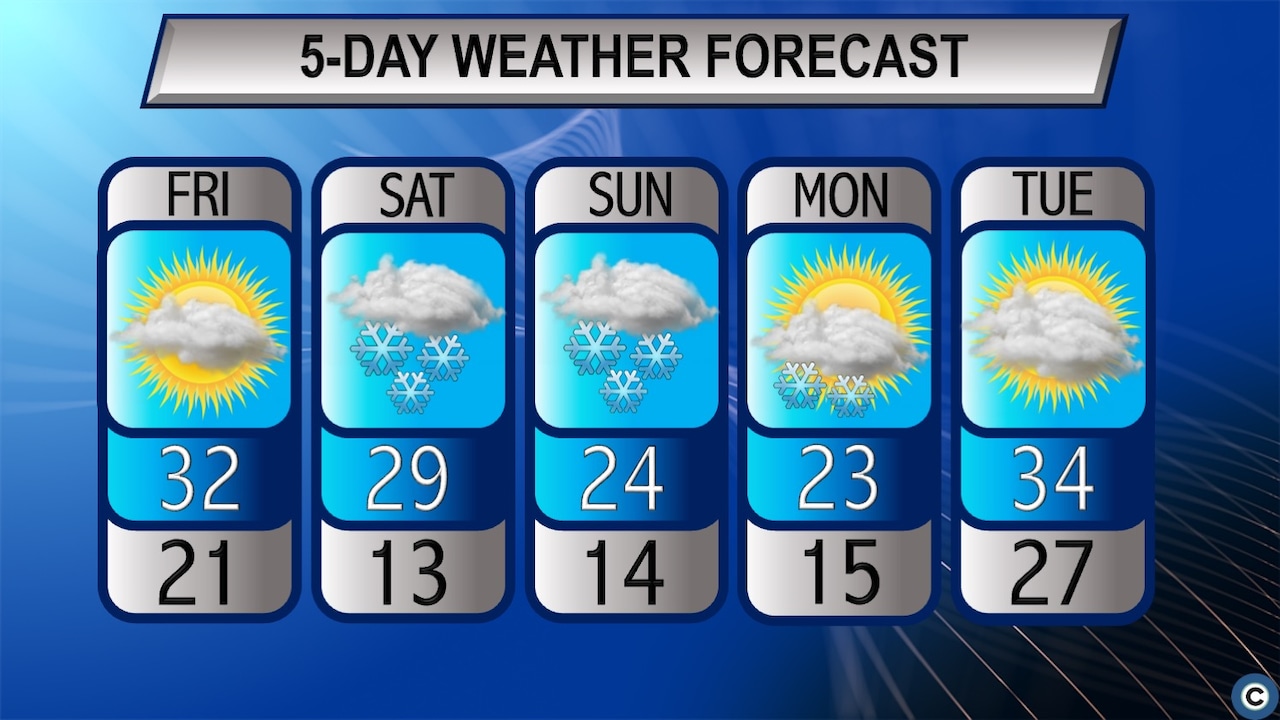 A clipper system moving in from the west, plus lake-effect snow behind the system, will impact the weekend in Northeast Ohio. Bone-chilling Arctic air also is expected Saturday night into Monday.cleveland.com
Snow won’t be the only concern this weekend, as a surge of Arctic air will drive temperatures sharply lower late Saturday night and into Sunday morning, bringing dangerously cold conditions to Northeast Ohio.
Overnight lows will drop into the single digits and teens, with wind chills falling to zero or below at times, especially early Sunday.
Daytime highs Sunday will only reach the mid teens to mid 20s, making it one of the coldest days of the season so far.
Forecasters urge residents to dress in layers, limit time outdoors and check on vulnerable neighbors and pets.
Brief improvement early next week
Lake-effect snow should gradually wind down late Sunday night into Monday as high pressure builds across the Great Lakes, though a few snow showers may linger.
Temperatures will remain cold to start the week, but a gradual moderation is expected by the middle of next week, bringing milder air — and eventually rain chances — back to Northeast Ohio.