
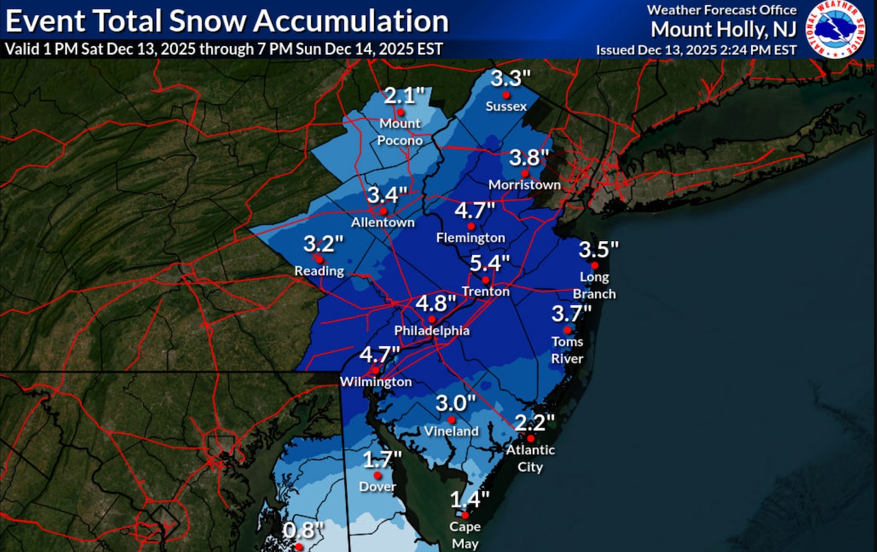
Winter storm warnings expanded overnight to include seven New Jersey counties now expected to get 3 to 7 inches of snow before the storm ends Sunday afternoon.
Heavy snow is continuing to fall through much of the state at daybreak Sunday.
The winter storm warnings remain in effect through 1 p.m. for Burlington, Camden, Gloucester, Mercer, Monmouth and Middlesex counties.
“Heavy snow expected. Total snow accumulations between 3 and 7 inches,” the National Weather Service said in the alert, which expanded from three to seven counties overnight. “Plan on slippery road conditions. Areas of blowing snow could significantly reduce visibility.”
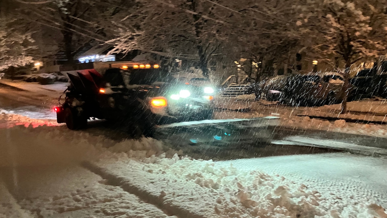
 Snow is continuing to fall on Sunday morning across much of New Jersey as a plow clears a road in Millburn. Winter storm warnings were expanded overnight to seven counties facing the highest snowfall totals of 3 to 7 inches.National Weather Service
 Winter storm warnings were expanded overnight to seven counties facing the highest snowfall totals of 3 to 7 inches.National Weather Service
The rest of New Jersey remains under winter weather advisories with at least 1 inch of snow expected statewide.
The National Weather Service said snow overspread most of the region as anticipated after midnight.
Snow will move out rapidly once the storm departs, with most areas dry by noon.
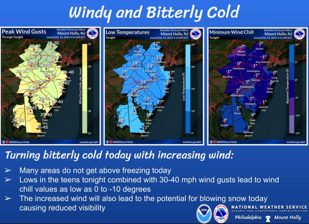
“In the wake of the snow, we turn bitterly cold and windy,“ the national weather service said ”Winds increase today reaching upwards of 30-40 mph into tonight. There is the potential for blowing snow today causing reduced visibility”
Temperatures will remain cold, only reaching the upper 20s to low 30s today.
Tonight brings the coldest conditions of the season so far, with lows dropping into the teens for most of New Jersey and wind chills plummeting toward zero in many areas.
 Snow is continuing to fall on Sunday morning across much of New Jersey as a plow clears a road in Millburn. Winter storm warnings were expanded overnight to seven counties facing the highest snowfall totals of 3 to 7 inches.National Weather Service
Monday will be breezy and cold with high temperatures well below normal, averaging around 30 degrees.
Isolated to scattered snow showers are possible late Monday into Monday night, particularly across northern New Jersey.
Monday night remains cold with temperatures in the teens and wind chill values in the single digits to low teens.
Tuesday brings dry weather as high pressure settles over the region, though temperatures remain below normal with highs in the mid 20s to mid 30s.
Tuesday night’s forecast calls for slightly higher temperatures with overnight lows in the 20s for most areas and teens for higher elevations.
Winds will be lighter at 5 to 10 mph, producing wind chill values in the teens and low 20s.
The weather pattern shifts Wednesday as highs climb into the upper 30s to upper 40s.
Thursday continues the warming trend with temperatures reaching the mid 40s to mid 50s ahead of a cold front.
Rain is likely Thursday night as the front moves through, with temperatures in the upper 30s to mid 40s.
Friday sees high pressure building in from the west with temperatures in the 40s.
Saturday may remain dry, though uncertainty exists regarding a low pressure system near the Great Lakes that could bring precipitation to the region.
Current weather radar
