
With only nine more sleeps until Christmas, we have now entered the meteorological window of predictability — in other words, forecasts are more accurate than just guessing the weather.
And the confidence in this year’s Christmas forecast, even at a lead time of more than a week, is higher than normal around Australia because the latest modelling between various agencies is showing relatively high consistency.
So, while the Bureau Of Meteorology (BOM) will not release its first predictions for the 25th until Thursday, the ABC is willing to publish the best possible guidance currently available.
Another heatwave could develop along the WA coast next week, with Perth likely to experience temperatures near 40 degrees Celsius. (Supplied: Jeroen Gerritsen)
Settled in the south, wet season ramps up in the north
After another heatwave and round of showers and thunderstorms sweep across southern Australia this week, next week’s weather is looking less extreme.
For most Australians, there is only one weather system worth watching around Christmas — a high-pressure system in the vicinity of the Great Australian Bight.
Highs generally bring settled conditions, and this particular system should control Christmas Day skies from the New South Wales coast to Western Australia, resulting in plenty of festive sunshine across southern states.
The only exception is onshore winds that may bring a light shower or two to Sydney and Melbourne, although not necessarily on Christmas Day.
Loading…
Hobart is likely to see a few pre-Christmas showers on the 23rd and 24th, but guidance favours that they will clear by the 25th.
However, temperatures across southern Australia will be far less uniform.
Winds spin anticlockwise around highs in the Southern Hemisphere, and the system’s position in the Bight, or possibly near Tasmania, should drive a relatively cool southerly airstream over south-east states next week.
The map below shows the average temperature forecast from a leading global model from the 22nd to the 29th compared to the long-term average, and it shows a cooler than normal week is tipped for much of the country, while the WA west coast could sweat through another heatwave.
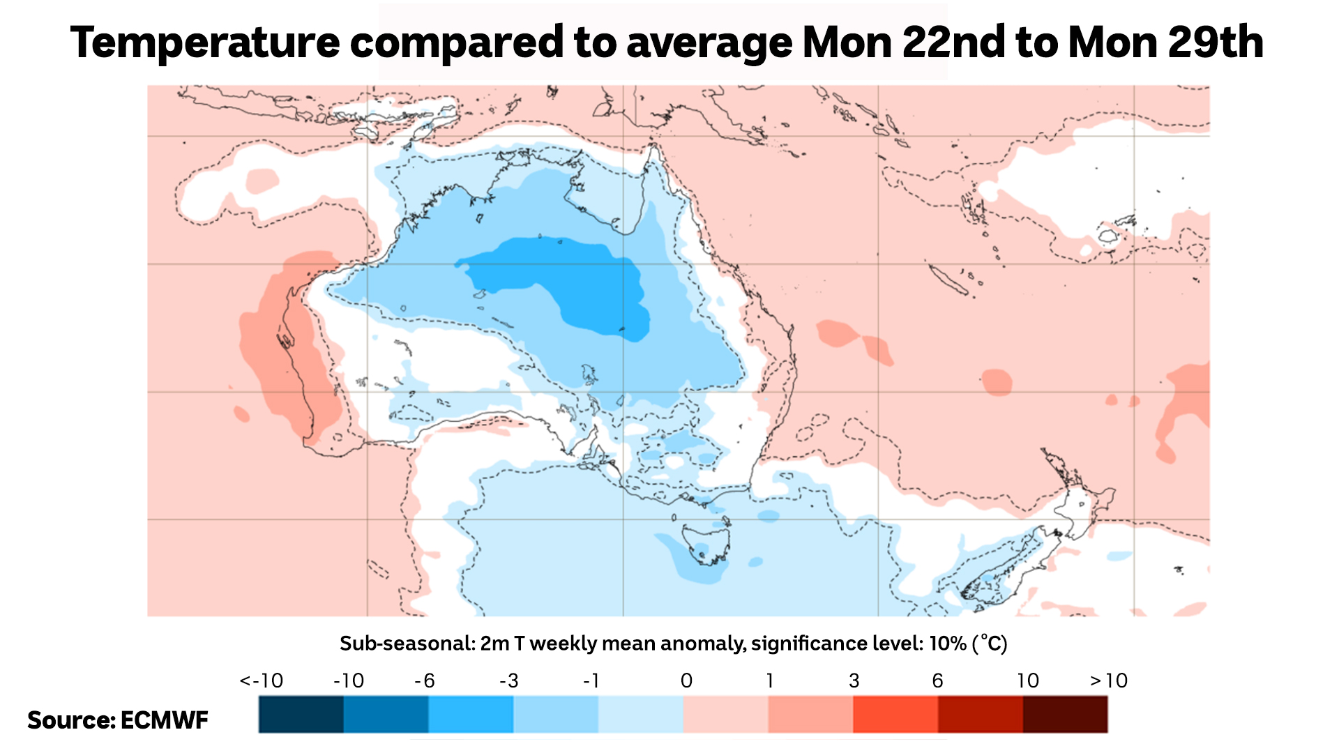
According to modelling from the European Centre for Medium-Range Weather Forecasts, next week is looking cooler for south-east and central Australia and hot on the west coast. (ABC News)
For WA though, lying to the west of the high will result in a hot north-easterly airstream and another potential heatwave through middle of the week
Perth is therefore likely to be the hottest capital, and the city could bake in Christmas Day heat close to 40 degrees Celsius.
For northern Australia, the atmosphere is looking far more volatile.
Much of Queensland will receive a pre-Christmas soaking early next week as a plume of tropical moisture delivers a band of widespread rain.
And while the rain should linger into Christmas Day for tropical Queensland, a current point of contention is whether or not the cloud band will have cleared from the state’s south-east in time for Santa.
For the Top End and Kimberley, typical wet season showers and thunderstorms are likely, but thankfully, there is little chance of a tropical cyclone.
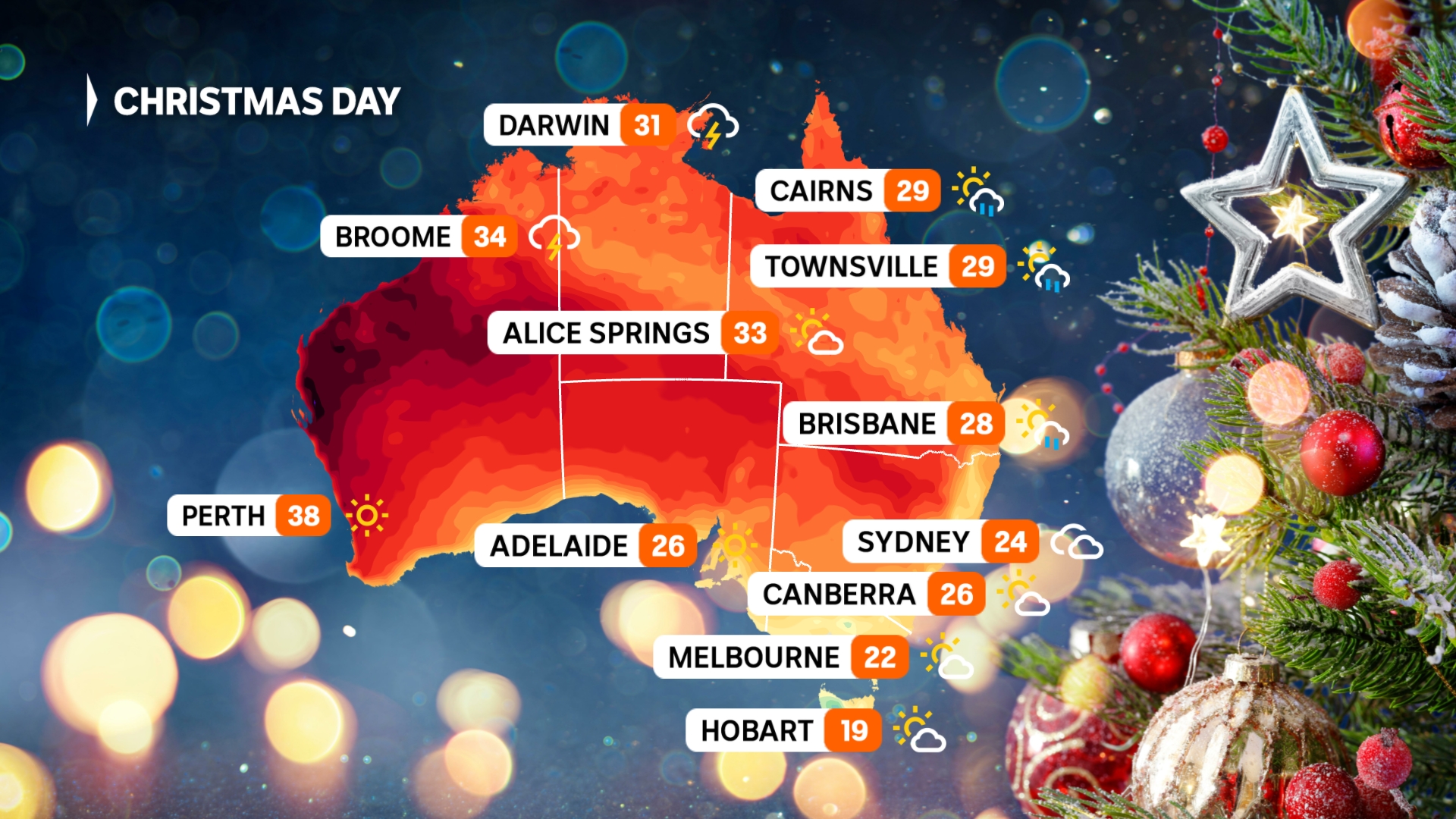
A dry Christmas Day is currently the most likely outcome for southern Australia, with cool temperatures in the east and hot weather in the west. (ABC News)
Capital city forecasts for Christmas DayAdelaide
Adelaide can expect a fairly typical December day this Christmas.
The city can expect mostly sunny skies around the 25th and a sea breeze should prevent uncomfortable heat.
ABC forecast: Mostly sunny, 26C.
Brisbane
Brisbane’s weather for the 25th is probably the trickiest to nail down at this stage.
The above-mentioned band of rain and the uncertainty surrounding when it will clear to the east of the southern Queensland coast leaves the city with the potential for precipitation.
ABC forecast: Possible showers, 28C.

A temperature of 28C is forecast for Brisbane on Christmas Day. (Supplied: Geoff Spencer)
Canberra
Canberra can expect a fairly typical December day this Christmas.
The city can expect mostly sunny skies, and at this stage, an uncomfortable heat is unlikely.
ABC forecast: Mostly sunny, 26C.
Darwin
Not surprisingly, Darwin may see downpours of showers and thunderstorms.
Some modelling is even hinting that a tropical low of very moist north-westerly airstream could bring more prolonged rainfall, but there are little to no signs of a tropical cyclone
ABC forecast: Showers and storms, 31C.
Hobart
Hobart is likely to see a dry Christmas.
Cold fronts early next week should deliver chilly summer weather, and possibly more snow to the higher peaks of Tasmania, but modelling is favouring the fronts will clear to the east by the 25th.
ABC forecast: Partly cloudy, 19C.
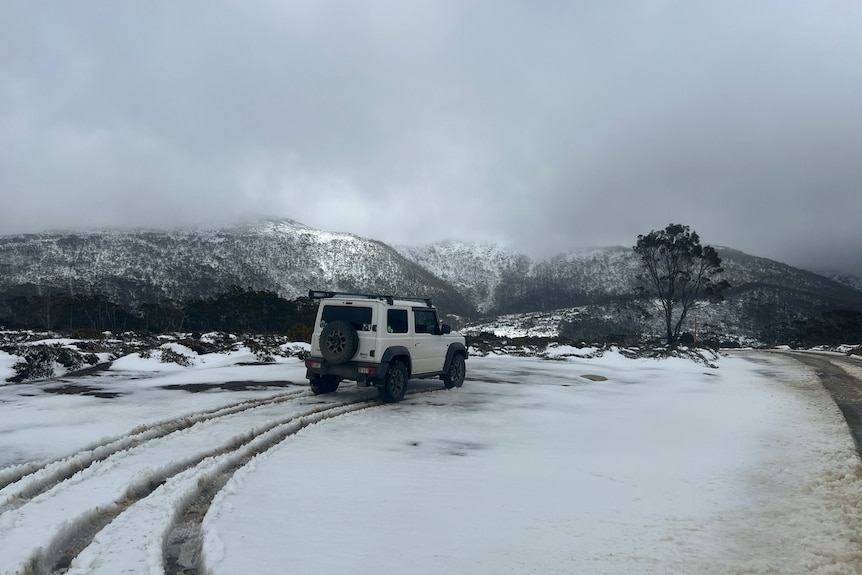
Snow fell on Tasmania’s higher ground on Monday, and unseasonable snow could again arrive early next week. (Supplied: Marielle Miller)
Melbourne
Melbourne is likely to experience a relatively cool Christmas.
A southerly airstream developing early next week should bring the odd light shower and below-average temperatures, which are likely to linger into the 25th.
ABC forecast: Partly cloudy, 22C.
Perth
A hot Christmas is likely in Perth.
A north-easterly airstream off the western deserts should send a very hot air mass to the WA west coast mid next week.
ABC forecast: Sunny, 38C.
Sydney
Sydney may see light showers through Christmas.
Modelling indicates winds are likely to be onshore along the NSW coast, but without any troughs, this should prevent heavy or persistent rain.
ABC forecast: Chance of a shower, 24C.
How can the weather be predicted more than a week ahead?
There’s a reason the BOM only provides a seven-day weather forecast.
The chaotic nature of the atmosphere leads to a steady decline in the accuracy of forecasts with time.
However, the skill in forecasting has improved by about one day per decade during the past 50 years, meaning a seven-day forecast in 2025 is as accurate as a two-day forecast in the 1970s.
And verification data shows that raw modelling during the past few years now exhibits skill to around 10 days.
However, a meteorologist can optimise the accuracy of medium-range forecasts even further by utilising multiple models and ensembles, surveying model trends and biases, and adjusting predictions based on broad-scale influences and climate.
Essentially, a good forecaster knows how much weight to put behind all available information.