
Palisades Tahoe, seen here last January, is currently fairly bare of snow, though things seem more promising after Christmas.
Max Whittaker/Special to the Chronicle
Christmas week is one of the busiest times of the year in Tahoe. But with the region in the midst of the worst start to a season in nearly a half a century, the question is: Will there be enough snow to ski?
Right now, the answer is complicated.
Palisades Tahoe, the largest ski resort in California, remains effectively closed, with just one small trail open thanks to manmade snow. Natural snowfall has been scarce, and despite an increasingly active storm pattern, most of the systems arriving this week are simply too warm to deliver meaningful snow at resort level.
Article continues below this ad
That doesn’t mean Tahoe stays dry. In fact, several storms are lined up. The problem is temperature.
Midweek storm: Rain, not snow
The first storm system arrives late Tuesday into early Wednesday. It’s a relatively weak storm, but more importantly, it carries a warm air mass. By the time steady precipitation reaches Tahoe around midnight Wednesday, temperatures at lake level will be near 40 degrees, with readings in the upper 30s along I-80 and U.S. 50.
San Francisco Chronicle Logo
Make us a Preferred Source on Google to see more of us when you search.
Add Preferred Source
Snow levels will hover near or above 9,000 feet, meaning only the highest peaks, such as Freel Peak on the south end of the lake, may see a few inches of snow. For ski resorts, it’s all rain. Strong winds will also be a factor, with gusts over 100 mph along Sierra ridgelines and 30 to 50 mph in lower elevations.
Article continues below this ad
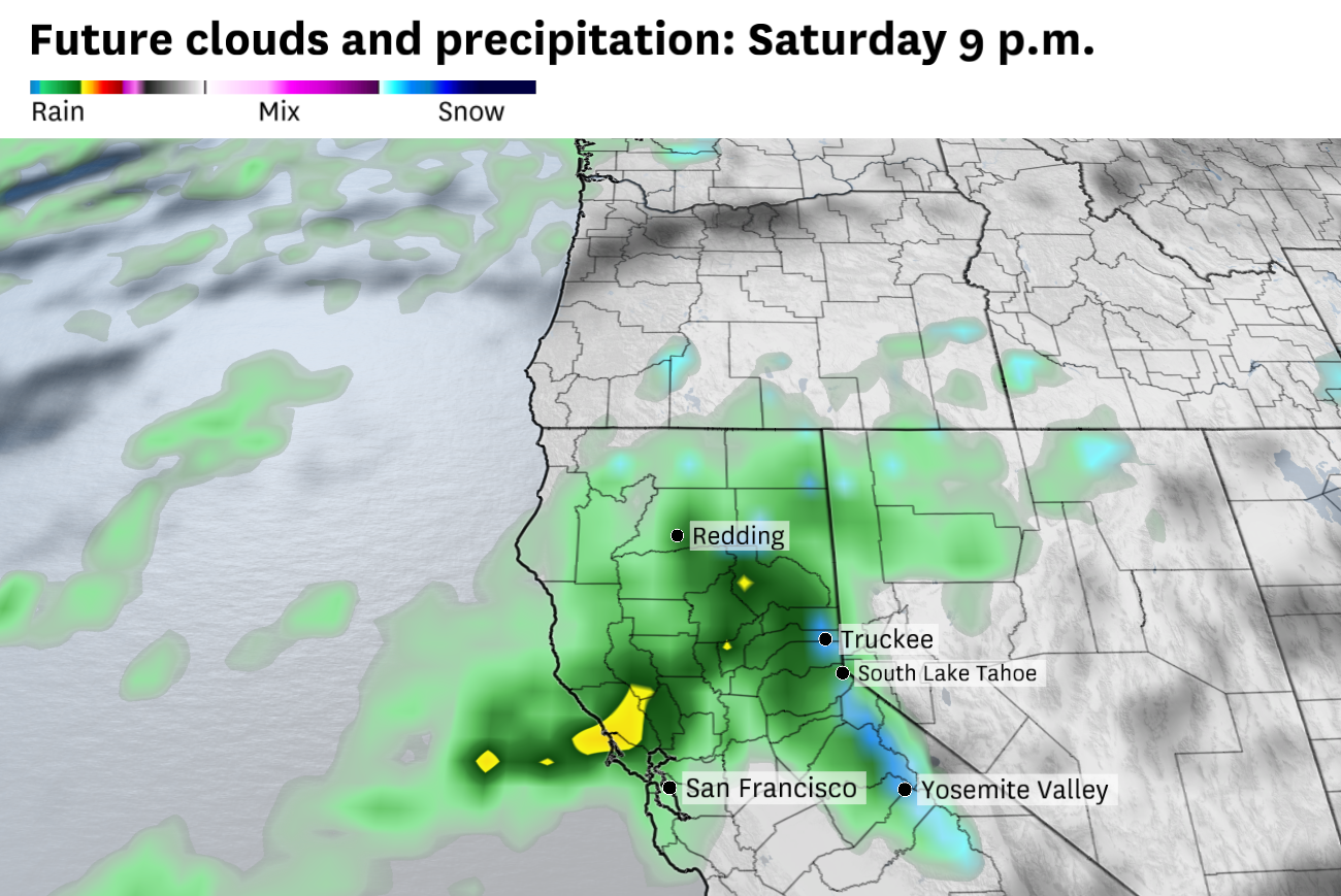
Friday into Saturday: Wetter, but still too warm
A second storm arrives Friday afternoon and lasts into Saturday. This one brings more moisture, but once again, temperatures remain the limiting factor. Snow levels are likely to stay above roughly 8,000 feet through Saturday morning, keeping most Tahoe resorts on the rain side of the line. Any snowfall will again be confined to the highest peaks.
The weekend storm system once looked promising for Tahoe snow, but the forecast has trended much warmer and it is expected to deliver mostly rain below 8,000 feet.
Baron/Lynx
With temperatures stuck in the 30s and 40s, resorts won’t have much opportunity to make snow between systems.
A colder shift after the weekend
The broader pattern stays active through the start of Christmas week, with new storms targeting the Sierra every 36 to 48 hours. Another system arriving late Sunday into Monday looks colder, with snow levels potentially dropping to around 7,000 feet by Monday morning.
Article continues below this ad
The issue with this storm is precipitation placement. At the moment, most of the moisture appears aimed north of Tahoe, toward Mount Shasta, which limits snowfall totals locally. Still, this system bears watching, as any southward shift in the storm track would quickly improve Tahoe’s snow prospects.
The best snow signal: Late next week
Looking farther out, forecast confidence drops, but the snow signal improves. Another storm expected around Tuesday night into Wednesday of next week comes with what appears to be the coldest air yet, with snow levels potentially falling to near 6,000 feet. If that system delivers, many Tahoe resorts could see 6 to 12 inches of snow from the peaks down toward the lodges.
Long-range forecast models show a much better chance for measurable snow across the Tahoe basin around Christmas.
WxBell
Another storm could follow around Dec. 26 or 27. It’s too early for specifics, but the overall trend favors colder systems as we move deeper into the holiday week.
Article continues below this ad
So snow is coming back to the Sierra, just not fast enough, or cold enough, for a strong start to Christmas week skiing. The more promising window appears to be after Christmas, when colder storms have a better chance to finally flip Tahoe from rain to snow.
Tuesday Bay Area breakdown
San Francisco: Clouds and fog will dominate the morning. Areas of dense fog may linger into the early afternoon near the coast and higher terrain, including Ocean Beach and the Outer Richmond. Temperatures will be mild, with highs in the mid-50s near the water to around 60 on the east side of the city, where sunshine may break through in the afternoon. Low clouds and patchy dense fog returns overnight with some light showers late and lows in the 50s.
North Bay: Areas of dense fog will persist in the morning, especially around Santa Rosa, Petaluma and along Highway 101. The fog will become patchier by afternoon, but the clouds will remain. Some showers are possible in the morning, with rain chances increasing later in the day. Highs will be in the upper 50s to low 60s. Light rain will continue overnight, with temperatures in the low 50s.
East Bay: The morning will be mostly cloudy, with areas of fog particularly along the Interstate 80 corridor and in the Oakland Hills and bayshore communities. The fog will thin but linger in spots during the afternoon. Some sunshine should break out across the interior in the afternoon; otherwise it’s a mostly cloudy day with highs in the upper 50s to low 60s. Rain chances increase overnight, especially for Oakland, Berkeley and Richmond. Temperatures will be mild with lows in the mid-50s.
Article continues below this ad
Peninsula: It will be mostly cloudy with areas of morning fog, especially near Daly City, Pacifica, San Bruno and along the Interstate 280 corridor. Clouds will linger for much of the day, with some brighter patches of sky possible in the afternoon. Highs will be in the low 60s. Clouds will return overnight with a slight chance of showers in the predawn hours and lows in the mid-50s.
South Bay: Early morning clouds and patchy dense fog will linger around San Jose and Santa Clara. The fog should lift by the afternoon, leaving mostly cloudy skies with some partial sunshine developing in spots. It will be mild, with highs in the mid-60s, among the warmest spots in the Bay Area. Mostly cloudy overnight with a slight chance at a stray shower or two and lows in the mid-50s.