
A 2,500-mile-long atmospheric river will take aim at the Bay Area from Sunday through Tuesday.
WxBell
After weeks of unusually dry December weather and earlier forecasts pointing to limited rain, the Bay Area is now trending toward a wetter pattern.
A notable shift in the weekend outlook shows increasing confidence that periods of moderate to heavy rain could arrive late this weekend and into early next week, as forecast models converge on a stronger atmospheric river targeting Northern California.
Article continues below this ad
While some variables are still in play, here’s what we know:
The coming weekend storm system was expected to be the last and strongest of three this week, tapping into a stronger atmospheric river moisture source. But forecast models have begun coalescing around an even wetter scenario pointed directly at the Bay Area.
San Francisco Chronicle Logo
Make us a Preferred Source to get more of our news when you search.
Add Preferred Source
By Saturday afternoon, a cold front moving south along the California coast will spread light rain showers over the Bay Area and back into the Sacramento Valley. This initial burst of rain will be modest, with a general 0.5 to 1 inches of rain spread out over a six- to 10-hour period.
By Sunday morning, forecast models show a general 0.5 to 1 inches of rain for the Bay Area.
WxBell
From there, we should see a break in the precipitation on Sunday morning. Meanwhile, moderate to at times heavy precipitation will continue in the Sierra Nevada. A lot of warm air will still be in place, so snow levels will likely remain above 8,500 feet, which means rain for much of the Tahoe basin.
Article continues below this ad
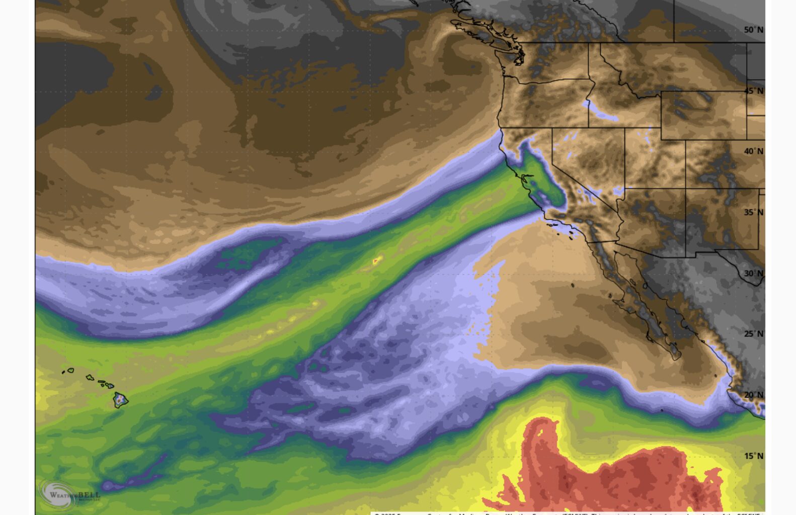
The break should be short-lived, though — and this is the part of the forecast that changed and will likely change again. The cold front responsible for the initial pulse of rain is expected to stall out while simultaneously tapping into a deep, elongated atmospheric river extending roughly 2,500 miles back toward Hawaii: a classic Pineapple Express.
This moisture plume may remain pointed at the Bay Area for as long as 36 to 48 hours, from Sunday afternoon through Tuesday. That would be an optimal setup for an extended period of moderate to at times heavy rain — though it is by no means a guarantee.
Just because the core of the atmospheric river is aimed at the Bay Area does not automatically translate to heavy rainfall totals. The atmospheric river is the kindling, but there still needs to be a trigger. That trigger often comes in the form of a secondary surface low pressure system developing along the boundary between the cold front and the atmospheric river. Those features are small-scale and often don’t resolve clearly in medium-range forecast models, which is why confidence in rainfall intensity remains limited at this stage.
A second burst of rain is expected to start on Sunday night and persist through Tuesday.
Baron/Lynx
Another key uncertainty is the placement of the atmospheric river itself. These moisture plumes are typically only about 100 to 200 miles wide, narrow enough that relatively small north or south shifts would dramatically change rainfall totals across the Bay Area. And those shifts are almost certain in the coming days.
Article continues below this ad
One thing that can be said with greater confidence is that the Sierra will be in line for an extended period of moderate to heavy precipitation. The mountain range itself will act as the trigger. Precipitation is the operative word here, as warm air is likely to keep snow levels above about 8,500 feet through Sunday before colder air begins to work in by Monday. Exactly how much cold air arrives and how low snow levels ultimately fall remains uncertain, but significant snowfall accumulation at most Tahoe ski resorts appears unlikely before Monday.
Then all eyes turn to the Christmas time frame. Early signals suggest another potentially stronger and colder storm system could impact the Bay Area and the Sierra, though confidence that far out remains low.
Wednesday Bay Area breakdown
San Francisco: The 26-day dry streak will end. Light rain showers will spread across the city in the morning. Amounts will be quite light, generally 0.10 inches for most areas. The rain ends by late morning, leaving a mostly cloudy day with spots of sunshine by the afternoon. It will be mild and a bit humid, with temperatures right around 60 degrees. Clouds fill in overnight, but conditions should stay mild with lows in the mid-50s.
North Bay: Light rain will fall across much of the North Bay in the predawn hours. The rain should end around 9 a.m., with light totals ranging from 0.10 to 0.25 inches. Mostly sunny skies should develop in the afternoon, a welcome change for places like Vallejo and Benicia. Temperatures will be mild, generally in the low 60s. Clouds and patchy fog returns overnight with lows in the mid-40s to around 50 degrees.
Article continues below this ad
East Bay: Morning showers should be confined to the Interstate 80/580/880 corridor as well as northern Contra Costa County. The interior East Bay may see no rain at all. Low clouds may hang around stubbornly in Richmond and Oakland, but sunshine should develop everywhere else. It will be mild and muggy, with highs in the low 60s. Overnight, skies will be mostly cloudy near the bay with some patchy fog, with clearer skies inland and lows in the upper 40s.
Peninsula: Light rain showers will come to an end in the morning. Totals will be less than 0.10 inches of rain. Low clouds and patchy fog will linger along the Peninsula into the afternoon, but some sunshine should break through. Temperatures will be mild, with highs in the low 60s. It will be mostly cloudy and humid overnight with patchy fog developing and temperatures in the upper 40s.
South Bay: Light rain showers will make for a bit of a wet morning commute in the South Bay, but amounts will be minimal, and the rain will end by 10 a.m. Low clouds and patchy fog will linger into the afternoon before partly sunny skies develop. It will be mild and muggy with temperatures in the mid-60s. Mostly cloudy skies, patchy fog and mild temperatures are expected overnight, with lows in the 50s.