![]()
Listen to this article
Estimated 3 minutes
The audio version of this article is generated by AI-based technology. Mispronunciations can occur. We are working with our partners to continually review and improve the results.
A series of cold weather warnings have been issued for inland sections of B.C.’s north coast and northeast B.C.
Environment Canada issued cold weather warnings for Fort Nelson, Muncho Lake-Stone Mountain Park, Atlin and Dease Lake on Tuesday.
Snowfall warnings are also in place for Whistler and the Fraser Canyon in southwest B.C.
Colin Fong, an Environment Canada meteorologist, said a weather system coming north from Washington state will also bring up to 15 centimetres of snow on the Coquihalla Highway (Highway 5) starting Wednesday morning.
“The other region is the Whistler region. And there, we’re expecting a little bit more snow to fall, about 15 to 25 centimetres,” he said.
“And again, all these warnings are tied to that one system coming in early Wednesday morning and then kind of moving out Wednesday afternoon.”
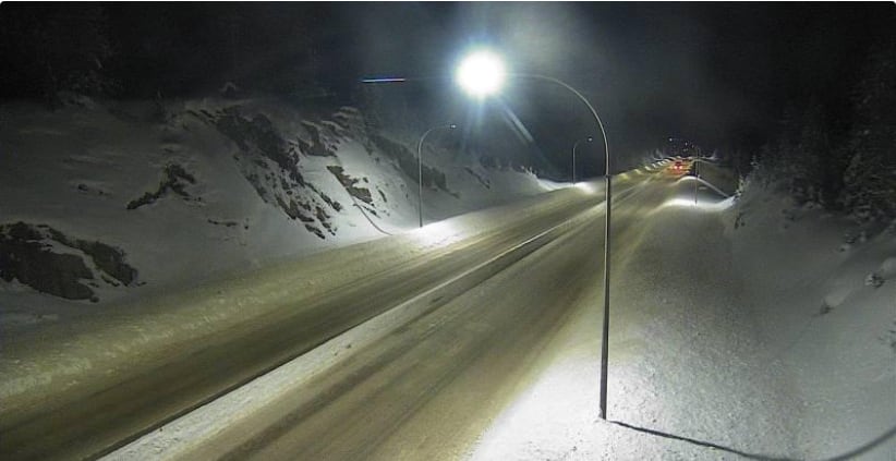 Highway 5 (Coquihalla Highway) is seen on a traffic camera about 61 km south of Merritt, looking north, on Tuesday. More snow is expected on Wednesday. (DriveBC)
Fong said that the short-lived snowfall along highway stretches like the Sea-to-Sky Highway (Highway 99) and the Coquihalla Highway (Highway 5) will likely impact holiday travellers.
“We ask people to drive slowly, drive carefully, and also prepare for a possible disruption to transportation services and utilities,” he said.
Further north, an Arctic ridge of high pressure has brought cold conditions to the northern B.C. Interior and the Peace area, combining with light winds to produce a wind chill that makes it feel like –45 C.
According to Environment Canada, the period of cold wind chills is expected to last from Tuesday night into Thursday.
An arctic outflow warning was also issued for the inland sections of the north coast, including Stewart, Terrace, and Kitimat, B.C., with bitterly cold winds expected to continue until Friday.
Environment Canada says an arctic airmass has combined with strong winds to created wind chill values near –20, with gusts up to 60 kilometres per hour near Terrace and Kitimat.
Temperatures are expected to range between –10 and –14 C.
“Frostbite and hypothermia can occur within minutes if adequate precautions are not taken when outdoors. Limit outdoor activities,” states the agency’s website.
Arctic outflow warnings are issued when outflow winds create wind chill values of –20 or less for six hours or more.
Subscribe to CBC’s Fort St. John Weekly for a round-up of the best news and stories from B.C.’s Peace and Northern Rockies.