
As officials warn of damaging winds, flooding rain and blizzard-like snow, California also may face another form of severe weather: tornadoes.
A rare alignment of atmospheric conditions will set the stage for potential waterspouts and tornadoes along the California coast Wednesday and Thursday. The window for potential twisters is much longer than usual and, while risk is low for any specific place, meteorologists and climate scientists say it is possible that someplace will see a tornado. The Central Valley also is at risk of funnel clouds and tornadoes Wednesday.
This is “the most favorable setup for more than a couple waterspouts/brief tornadoes than I’ve seen in quite some time in this part of the world,” said Daniel Swain, a climate scientist at UC Agriculture and Natural Resources.
While California will probably experience at least one tornado from Tuesday night through Friday, the overall risk is low for any given point. Flooding from heavy rain and fallen trees from non-tornadic winds present a greater risk for most people.
Parts of Los Angeles County were under a tornado warning Wednesday morning, but the National Weather Service canceled the warning shortly after it was issued as radar no longer indicated rotation in the lower atmosphere.
The tornado risk was forecast to come in waves. The cold front that triggered the tornado warning in Los Angeles County could produce funnel clouds and a brief twister as it moves east through Orange County in the afternoon. In addition to the low-end tornado threat, the cold front will bring downpours and erratic winds with it.
Wednesday afternoon will present a window for severe thunderstorms in the Central Valley. The tornado risk is highest from roughly Redding to Modesto, particularly if sunshine pokes through the clouds. That would heat the ground and add instability to the lower atmosphere.
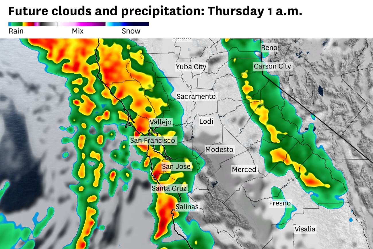
Tornado chances are highest in the Bay Area from Wednesday evening through Thursday. Multiple squall lines capable of spinning up funnel clouds, waterspouts or a tornado were forecast to move through the region. The first was expected to reach San Francisco sometime between 5 and 8 p.m., and another was forecast to hit around midnight. In addition to potential tornadoes, the National Weather Service warns of damaging thunderstorm winds and cloud-to-ground lightning.
Residents should have multiple ways of receiving emergency notifications should a tornado warning be issued overnight.
“There probably will be waterspouts and even a land-based weak tornado for each of these episodes, particularly on Christmas morning,” said John Monteverdi, a meteorologist and professor emeritus at San Francisco State University.
California often lacks the necessary atmospheric ingredients for tornadoes, but this week’s storm is forecast to contain the necessary elements.
The storm originated nearly 1,000 miles southwest of San Francisco, in the moist subtropics, but was predicted to ingest chillier Arctic air. This clash of air masses is conducive to thunderstorms. Additionally, strong winds are expected through the lower levels of the atmosphere, which may help individual storm cells spin into a funnel cloud or tornado.
Late December is the heart of California’s tornado season. The state averages nine tornadoes per year, with most of those in coastal areas in winter and the Central Valley in spring.
In December 2024, a tornado in Scotts Valley (Santa Cruz County) flipped vehicles and injured people. The same day, a tornado warning was issued in San Francisco. Damage was determined to be non-tornadic, although straight-line winds snapped or uprooted dozens of trees around Golden Gate Park.