
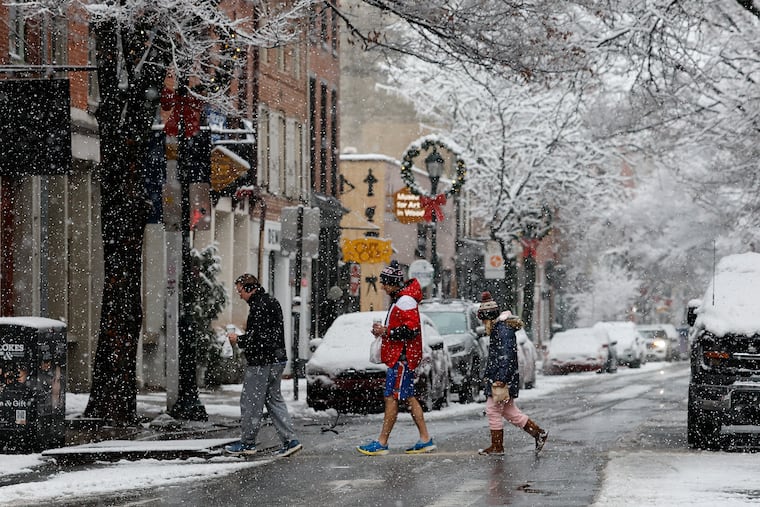
Many Philadelphians woke up Friday morning with alerts about wintry weather. The region had missed out on a white Christmas, but snow, sleet, and rain were forecast to bring a cold mix of precipitation to the streets of the city and surrounding areas.
The wintry mix was moving into the area during the afternoon and expected to continue into Saturday morning. It threatened to disrupt post-holiday travel with icy roads, and promised a challenging cleanup that one meteorologist said would be like “shoveling sand.”
Snow was moving in during the afternoon, followed by expected sleet. Intermittent rain was to complete the triple threat, adding itself to the mix overnight, with temperatures expected to drop to 30 degrees.
“Because of the sleet and freezing rain aspect, the accumulations will not be especially high, but that doesn’t mean they won’t be hazardous,” said Ray Martin, a meteorologist in the National Weather Service’s Mount Holly office.
According to the National Weather Service, places south and east of Philadelphia were expected to see mostly rain. Areas near the Delaware River could be icy. And, folks north of I-78 were more likely to see snow — potentially five to eight inches in central and northern New Jersey.
But for the Philadelphia region, just one to three inches of snow are expected, and most of it, Martin said, will come as sleet.
Sleet tends to be more compact than snow, demanding more effort when it comes to shoveling or plowing it off sidewalks, entryways, and garages.
For Martin, this will look like: “a lot of little ice balls, basically frozen raindrops, covering the ground. It will be like shoveling sand.”
With the weather conditions creating slippery roads, the meteorologist warned drivers to operate with caution and try to avoid streets until they are treated. If possible, he recommended waiting to drive until Saturday midmorning, when temperatures are expected to rise above freezing. Skies are expected to be cloudy, but the area should get a break in the precipitation.
Regardless of the ultimate snowfall totals, the conditions during and after the storm aren’t likely to be pleasant.
“It’s not going to be fun, and it won’t look as bad as it will actually be,” Martin said.
Early Friday evening, PennDot announced a temporary speed-limit reduction for the major highways in the five-count Philadelphia region, including on Interstates 76 and 95, as well as 476 and 676 and 295.
The reduction to 45 mph will also be in effect for U.S. Routes 1, 30, 202, and 422, as well as some state routes.
The city’s office of emergency management sent out traffic alerts, asking drivers to exercise caution until 10 a.m. Saturday.
Due to the slippery conditions, acting New Jersey Gov. Tahesha Way declared a state of emergency across her state, urging people to monitor official updates, remain off the roads unless necessary, and stay safe.
As of late Friday afternoon, 149 flights at Philadelphia International Airport had been delayed, and 143 were canceled, due to the storm. For folks with holiday traveling around the corner, make sure to track flight statuses at Philadelphia International Airport.
The storm comes as Philly prepares to commemorate the 30th anniversary of the massive 1996 snowfall, when the city registered 30.7 inches between Jan. 7 and Jan. 8.
So far this season, Philadelphia has already seen more than half the snow last winter brought. This year’s seasonal total stands at 4.2 inches, while the city saw 8.1 inches during the entire 2024-25 winter.
Regardless, conditions are set to improve in Philadelphia by early next week, with Monday expected to bring a high of 58 degrees and a low of 28, and the year waving farewell Wednesday with a high of 38 degrees and a low of 30, according to AccuWeather.