

The powerful storm system that’s forecast to bring blizzard conditions to the Upper Peninsula and unfurl high winds across the state could also whip up waves on Lake Superior that rival record-setting heights measured nearly a decade ago.
The forecast calls for waves approaching 28 feet on Lake Superior by Monday morning. The largest waves ever recorded on the Great Lakes were 28.8 feet. Those were measured in Lake Superior between Marquette and Munising on Oct. 24, 2017.
For comparison, the National Weather Service models have said the Lake Superior waves on the night the Edmund Fitzgerald sank in 1975 were in the range of 25+ feet.
It’s unclear how any record-breaking waves on Monday would be measured, as many seasonal buoys have been pulled from the water and forecasters say the only buoys left in the lake are pretty far away from the spot near Pictured Rocks National Lakeshore where the waves are supposed to peak.
The map below shows the forecast for the Great Lakes wave heights on Monday morning, according to the National Weather Service.
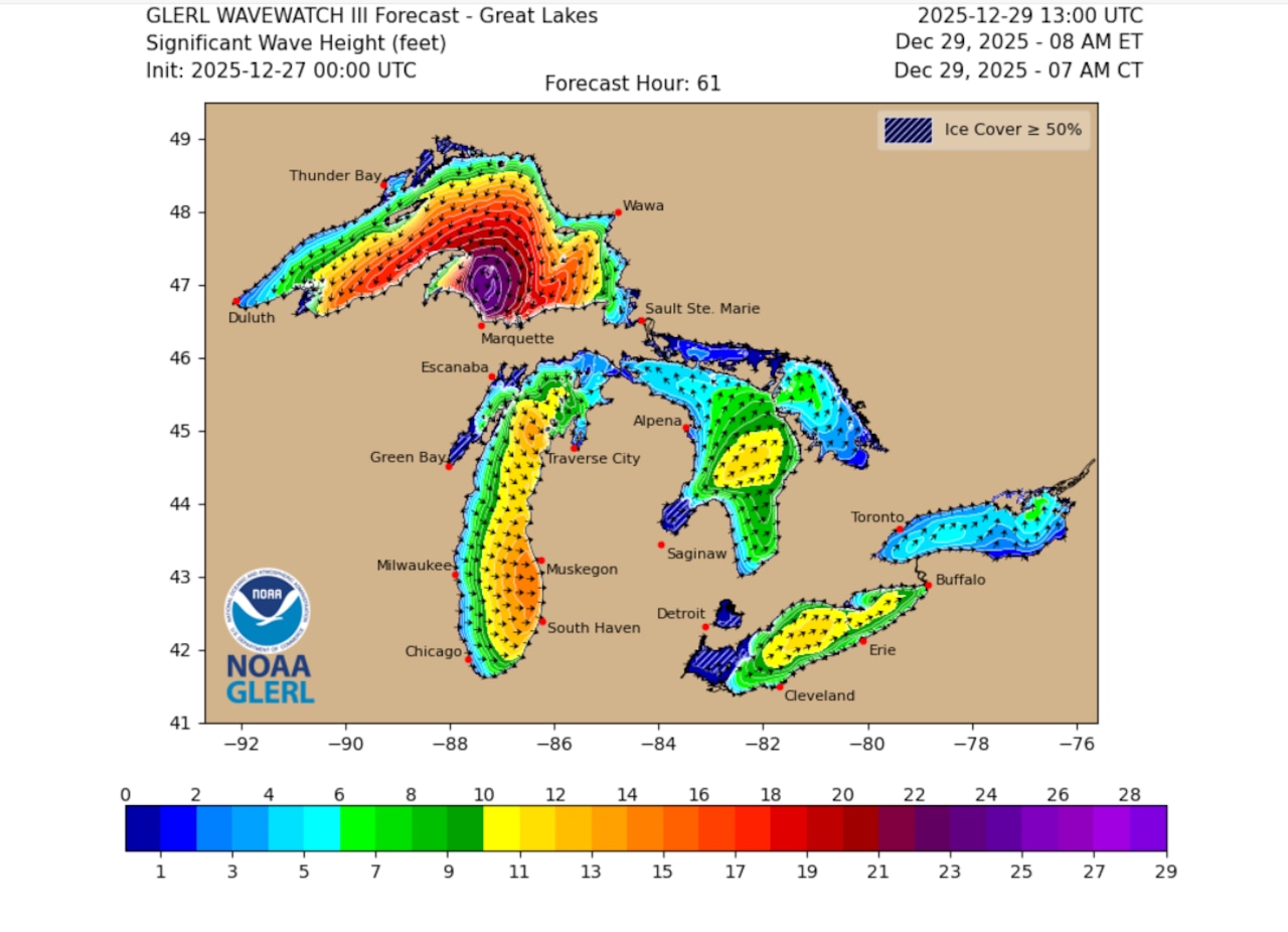 Wave heights on the Great Lakes are forecast to reach their storm system peak on Monday.Graphic provided by the National Weather Service
Wave heights are expected to be high on all the Great Lakes as Sunday’s storm intensifies and carries over into Monday.
Storm Warnings – a step higher than Gale Warnings – are now hoisted over Lake Michigan as well as Lake Superior. While Lake Superior’s top waves could hit 28 feet or more, Lake Michigan’s waves could top 18 feet.
Wind gusts could reach 58 mph over Lake Michigan, and up to 70 mph over Lake Superior, the NWS said. Lake Huron currently has a Gale Watch, with wind gusts to 54 mph forecast, and waves up to 26 feet.
Lake Erie, which is in a perfect position to get pushed by strong winds, may experience a seiche on Monday. This is a water event when winds push the lake’s water from one end to the other, like water sloshing in a bathtub. Gusts over Lake Erie could reach 70 mph and waves could reach 17 feet.
Heavy freezing spray is also forecast for the Great Lakes over the next several days. This spray can ice-over on freighters and other vessels, making travel dangerous. As this storm system starts to move through the Great Lakes today, we can expect to see freighters that are not in port move closer to shore and into sheltered areas. You can check their status on websites like Marine Traffic.
To see the latest update on this storm coverage, follow our headlines on the MLive Weather page.