
A tropical disturbance is expected to threaten the U.S. Gulf Coast with intense rainfall and flooding this week — and it may even spawn the next named storm of the 2025 Atlantic hurricane season, Dexter.
Downpours associated with the tropical disturbance across Florida resulted in an isolated report Monday of more than 9 inches of rainfall outside of Tampa. Widespread rainfall totals of an inch to 3 inches were common in South Florida and along Florida’s Gulf Coast, with more rainfall expected to add up to 4 inches through Wednesday.
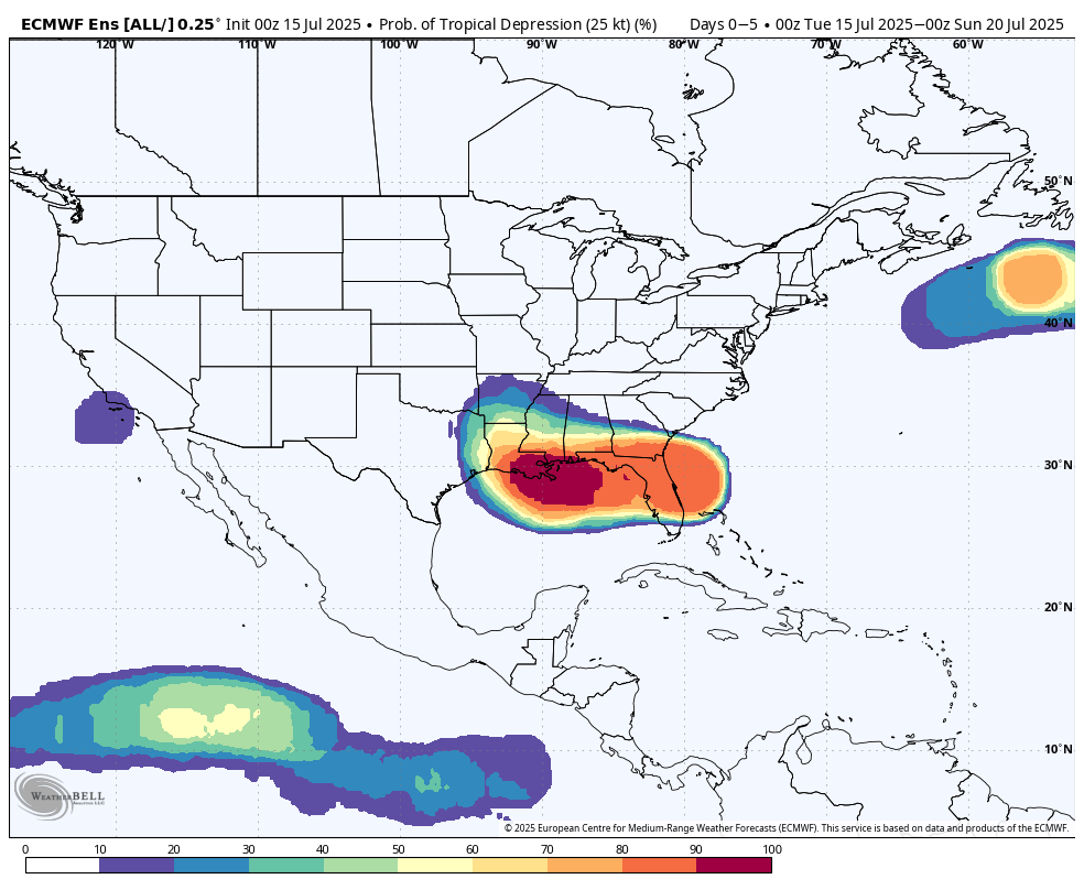
The National Hurricane Center gave Invest 93L a 40% chance of further tropical cyclone development through Thursday morning in their 8 a.m. update Tuesday.
Surface analysis Tuesday morning showed Invest 93L roiling near Cape Canaveral along Florida’s Atlantic coast. The decision Monday evening to designate the slow-moving system of low atmospheric pressure as an invest area allowed forecasters to run specialized models and collect data to better assess the tropical disturbance.
Invest 93L was producing pockets of heavy rainfall in the Orlando area Tuesday morning and will continue to send downpours across the state as the low pressure tracks westward through Florida. Forecast models suggest Invest 93L will emerge over the northeastern Gulf of Mexico late Tuesday.
Once Invest 93L moves over the Gulf, it’ll be in an environment favorable for more tropical cyclone development. Water temperatures across the Gulf of Mexico are running about 2 degrees above normal. Temperatures are closer to 90 degrees along Florida’s Gulf Coast, where shallower water is better able to retain high levels of heat.
Additionally, wind shear values are favorable to support further organization of thunderstorm activity. Unlike severe storms that occur over land and thrive in environments with changing wind patterns aloft, tropical systems can be ripped apart by high wind shear. Generally, values of wind shear less than 20 mph allow for thunderstorms to develop deep into the atmosphere without being torn apart by higher winds aloft.
Could Dexter form? It’s possible.
Confidence has grown higher that Invest 93L may become the Gulf of Mexico’s next tropical depression. It’s even a possibility that Invest 93L could go on to become the next named storm of the season, Dexter. The Gulf already saw Tropical Storm Barry emerge from off the eastern coast of Mexico in late June, before Barry’s remnants contributed to the deadly, catastrophic Fourth of July flooding in the Texas Hill Country.
Global and hurricane forecast models, like the ones used by the hurricane center to create their forecasts, suggest whatever Invest 93L becomes will stay mostly east of Texas.
Why is that? A ridge of high atmospheric pressure is expected to be parked over northern Mexico by Friday. This feature may be just close enough for the tropical disturbance to be steered toward the central U.S. Gulf Coast, particularly Louisiana and Mississippi.
The influence of high pressure likely won’t be enough to keep tropical downpours away from Southeast Texas.
A deep plume of tropical moisture will arrive Thursday night into Friday, bringing with it the risk of heavy rainfall and localized flooding, especially east of Houston and into Louisiana. If your weekend travel plans take you to Baton Rouge or New Orleans Friday or Saturday, be aware that the area will be under a level 3 out of 4 risk, or at least a 40% chance, of flash flooding, according to the National Weather Service’s Weather Prediction Center.
Whether Dexter forms from this disturbance this week or not, residents near and along Texas’s Gulf Coast are encouraged to closely monitor the forecast.