
![]()
Listen to this article
Estimated 4 minutes
The audio version of this article is generated by AI-based technology. Mispronunciations can occur. We are working with our partners to continually review and improve the results.
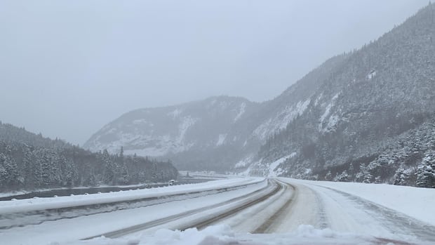
Strong winds are expected to sweep across the island of Newfoundland Sunday night, with the west coast getting hit with up to 40 cm of snow at the same time.
“Really strong winds across the board with this one,” Environment Canada meteorologist Justin Boudreau told CBC’s Weekend AM.
He says that a rapidly developing weather system is “poised to go over western Newfoundland” Sunday night and into Tuesday.
According to Environment Canada, there is a yellow winter storm warning in place for the island’s western region, indicating hazardous weather with moderate, localized or short-term impacts.
The winter storm is expected to hit Channel-Port aux Basques all the way up to the Great Northern Peninsula, and will reach inland towards Grand-Falls Windsor, starting Sunday night into Monday.
Along the coast there will be a total snowfall of 20 to 40 centimeters, with 80 to 110 km/h winds, with gusts up to 120 km/h. High winds are expected to last until Tuesday morning.
Meanwhile, Channel-Port aux Basques to Grand Falls-Windsor will see 15 to 20 cm of snow, which will transition into ice pellets and freezing rain overnight. Winds up to 120 km/h are expected starting Monday.
Winds reaching 130 km/h are expected overnight Sunday night in the Wreckhouse area.
Environment Canada says that the combination of snow and strong winds will result in blizzard conditions, creating poor visibility.
Travellers should consider modifying plans to avoid travel or to allow extra time.
Orange wind warning
While Boudreau expects that there will be “a whole bunch of snow mostly for the western half of the island,” he says “the eastern half will see a brief shot of it.”
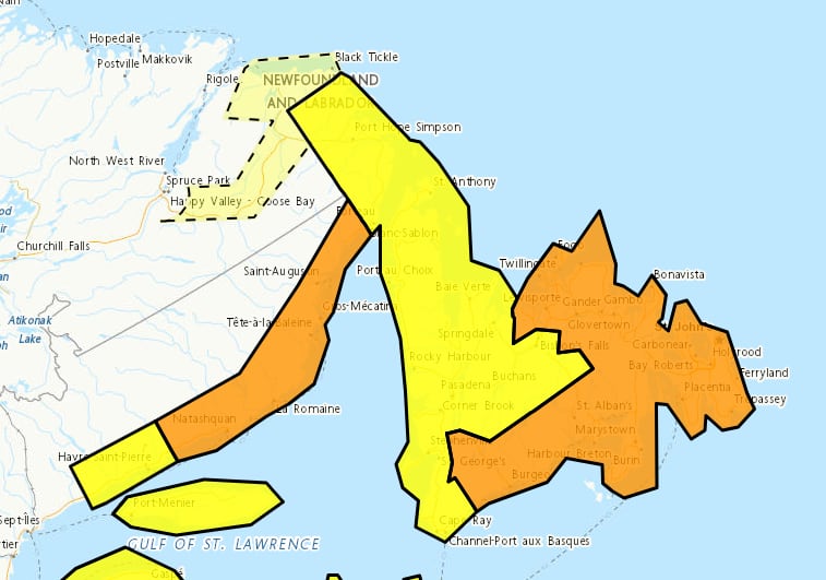 Environment Canada has yellow winter storm warning alerts in place for western Newfoundland and parts of southern Labrador, meanwhile orange wind warnings are in place for the eastern region and Avalon peninsula. (Environment Canada)
Boudreau says that eastern Newfoundland will see ice pellets and freezing rain at various times starting Sunday night into Monday.
Environment Canada has an orange wind warning in place for eastern Newfoundland and the Avalon, starting Monday afternoon.
Orange alerts indicate severe weather that will have major, widespread and longer-lasting impacts.
Very strong winds are expected in this region, with maximum wind gusts going above 100 km/h.
Although not as significant as the west coast, some rainfall and snowfall is expected.
Environment Canada still says walking and driving may still become hazardous and high-sided vehicles could be overturned.
Significant rain on the South Coast
Boudreau says there will be significant rain along the south coast from Burgeo to the Burin Peninsula, possibly reaching 25 to 35 mm.
There is a yellow rainfall warning in place starting Sunday night in this region. Heavy rain is expected, and Environment Canada warns that the frozen ground will reduce its ability to absorb rainfall.
Rain and snowmelt could create water pooling and localized flooding in low-lying areas in this region, and freezing temperatures Monday night may make roads and walkways icy and slippery.
There is also an orange wind warning in effect for that region, with wind gusts expected to reach 100 km/h and 130 km/h along the coast.
Some impacts in Labrador
South East Labrador will feel some impacts, with a yellow winter storm warning in place for Norman Bay to Lodge Bay and Red Bay to L’Anse-au-Clair.
Snowfall and high winds are expected to start in this region Monday morning.
And there is a yellow winter storm watch in place for Cartwright and in through the Trans-Labrador Highway.
Environment Canada meteorologists are monitoring a weather system that has potential to bring snowfall and strong winds to this region.
Download our free CBC News app to sign up for push alerts for CBC Newfoundland and Labrador. Sign up for our daily headlines newsletter here. Click here to visit our landing page.