
That January thaw is now firmly in the rearview mirror across Southern Ontario after a major winter storm last week reminded us that we are still very much in the heart of winter. That storm brought widespread snowfall to the region, with many areas picking up significant accumulations and some seeing totals in the 30 to 50 cm range by the time it wrapped up on Thursday.
While we are not expecting another large, widespread system-related snowstorm of that magnitude in the immediate future, the pattern is far from quiet. In fact, the bigger story going forward will be a prolonged stretch of much colder weather as we head deeper into January. A true deep freeze is set to take hold beginning early this upcoming week and is expected to persist for much of the remainder of the month.
With temperatures plunging and the Great Lakes still largely ice-free, the setup becomes ideal for an active period of lake effect snow. Cold polar air moving over relatively warm lake waters is the perfect fuel source for snow squalls, and that lake effect snow machine is about to kick into high gear.
Ironically, this could end up being one of the last notable lake effect events of the season, as colder temperatures later this month will eventually lead to increasing ice coverage. Once the lakes begin to freeze over, the moisture supply is cut off, and snow squalls shut down. For now, though, the lakes are open and very capable of producing heavy snow.
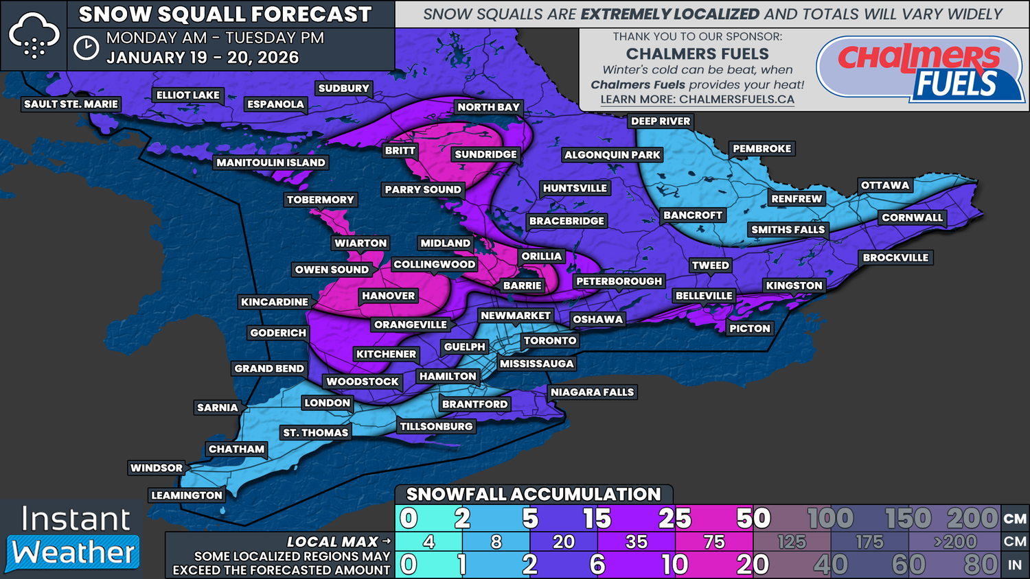
That lake effect machine is expected to come roaring to life starting on Monday. By the time activity winds down late Tuesday, some communities could be digging out from substantial snowfall. Totals of 25 to 50 cm are possible in parts of Grey Bruce, Simcoe County and areas north of Parry Sound, although, as always with lake effect snow, not everyone will see those kinds of amounts.
Snow squall activity is expected to begin organizing overnight into Monday morning along the eastern Lake Huron shoreline. This activity will expand throughout the morning, affecting Grey Bruce, the Bruce Peninsula, and regions northeast of Georgian Bay. Additional lake effect bands are also expected to develop off Lakes Erie and Ontario, impacting parts of the Niagara region and Prince Edward County as early as Monday morning.
Conditions will deteriorate quickly on Monday afternoon as strong winds develop across much of Southern Ontario. Wind gusts of 60 to 90 km per hour are expected, and when combined with ongoing snow squalls, this could lead to dangerous blizzard conditions, particularly east of Lake Huron and in Prince Edward County.
The worst conditions are expected during the afternoon and early evening hours, with blowing snow and near zero visibility at times. There is also some concern that blowing snow could briefly impact parts of the Golden Horseshoe around the evening commute.
Through Monday night and into Tuesday morning, attention shifts toward a potentially intense and long-lasting snow squall. This band may set up across the Bruce Peninsula, extend across Georgian Bay, and come ashore into Simcoe County and possibly the Kawartha Lakes.
Some models suggest this squall could lock into place for 6 to 12 hours before finally lifting northward by Tuesday afternoon. Where it becomes stationary, snowfall rates could be intense, and accumulations could climb rapidly in a short period of time.
Adding to the concern will be the arrival of bitterly cold air late Monday. Temperatures will fall sharply, and by Tuesday morning, wind chills could make it feel like minus 20 degrees or colder across much of Southern Ontario. In some areas, wind chills could dip even lower.
When combined with heavy snow and strong winds, conditions could quickly become life-threatening for anyone who becomes stranded. Travel is strongly discouraged in the hardest hit regions beginning late Monday morning and continuing through Tuesday.