
The city could see up to 2 cm of snow on a ‘bone-chillingly cold’ Monday. Jessica Smith has your seven-day forecast.
A snow squall warning has ended for Toronto and regions across the GTA after Environment Canada advised of “brief but intense” periods of snowfall this afternoon.
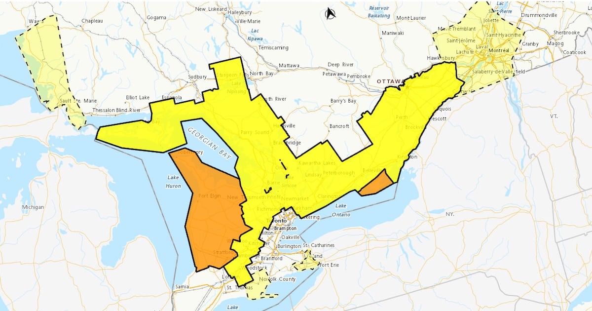
Areas north of Toronto, including Caledon, Aurora, and Orangeville, as well as communities east of the city, including Pickering, Ajax, Whitby, and Oshawa, are currently under a yellow alert. According to the national weather agency, these areas could see up to 10 centimetres of snowfall today.
“Additional snow squalls are expected later this afternoon and into the evening. Significantly reduced visibility will be the primary concern as opposed to snowfall accumulation as snow squalls are expected to shift through the area rather quickly,” the warning read.
“Travel will likely be hazardous. Visibility will likely be suddenly reduced to near zero at times.”
A snow squall warning, orange alert, was previously issued for parts of Niagara Region, including Welland, Fort Erie, Port Colborne, and Niagara Falls. Conditions have improved and those areas are now under a yellow alert.
Ontario Provincial Police previously said whiteout conditions were reported in the region on Monday morning.
Warning of winter weather and whiteout conditions in the Niagara Region right now.
The weather may be clear in some areas in the GTA but the road and driving conditions in Niagara Region are treacherous right now.
Check for weather and road updates and adjust your schedule, if… pic.twitter.com/C1OgdyZoLM
— OPP Highway Safety Division (@OPP_HSD) January 19, 2026
Bitterly cold temperatures arrive in Toronto
While it appears Toronto will be spared from heavy snowfall, brutally cold temperatures are expected this week.
A cold snap begins Monday, which will see a high of -6 C, feeling closer to -17 with the wind chill. The mercury will plunge to -15 C overnight Monday, feeling closer to -25 with the wind chill.
Even more frigid weather is in the forecast on Tuesday. The city will see a high of -9 C but wind chill values will make it feel like -26 in the morning and -19 in the afternoon.
The temperature will drop to a low of -13 C on Tuesday night.
Wednesday will bring a brief reprieve of the freezing conditions, with the national weather agency calling for a high of 0 C.
But bitterly cold weather will creep back in on Thursday.
Toronto is expected to see a high of -4 C on Thursday, -7 C on Friday, -8 C on Saturday, and -10 C on Sunday.
Given the frigid forecast, the City of Toronto said it will be opening additional warming centres at 5 p.m. on Monday at the Cecil Community Centre, located at 58 Cecil Street, and at the Jimmie Simpson Recreation Centre, located at 870 Queen Street East.
Additional Warming Centres will open at 5 p.m. due to extreme cold temperatures:
📍 Cecil Community Centre, 58 Cecil St.
📍 Jimmie Simpson Recreation Centre, 870 Queen St. E.
The previously opened Warming Centres remain open. Find locations: https://t.co/tRpue1Palo. pic.twitter.com/hQ9lDmMxnk
— City of Toronto 🇨🇦 (@cityoftoronto) January 19, 2026