
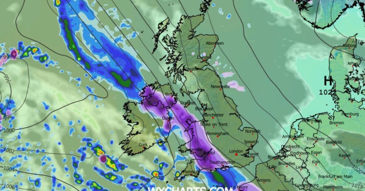
Alarming new weather charts show a diagonal wall of snow set to blast Britain on Tuesday, January 27, hitting 19 UK cities – from the south coast to Northern Ireland. Forecasters have warned that the second half of January is set to see the UK sit right in the middle of two vying systems.
An Atlantic low-pressure system will repeatedly attempt to move in from the west, bringing moist air and unsettled conditions, while high pressure over eastern Europe and Scandinavia could push westwards, encouraging colder and more stable air to edge into eastern UK. Now, new WXCharts.com maps for Britain for 6pm on Tuesday, January 27, show a diagonal snow front moving into the UK, hitting over a dozen cities in England, Wales and Northern Ireland.
Heat maps for the same day show that away from the snow front, areas of the Scottish Highlands will wake to sub-zero temperatures – with the mercury set to be as low as -2C (28.4F).
Other charts show that parts of the UK are set to be hit by heavy rain showers that same day, with the weather looking particularly wintry by the end of the month and the start of February.
On Tuesday, January 27, UK cities that charts predict could be affected by snow include:
Exeter; Portsmouth; Chichester; Winchester; Salisbury; Southampton; Swansea; Cardiff; Wells; Bath; Bristol; Newport; Gloucester; Hereford; Bangor; Newry; Armagh; Lisburn and Belfast.
A Met Office long-range forecast for Friday, January 23, until Sunday, February 1, warns of an “increase” in the “chance of snow across parts of the country”.
It reads: “Throughout this period, the UK will see a battle between Atlantic weather systems attempting to push in from the west while high pressure and colder, drier conditions attempt to exert some influence from the east.
“Initially, milder Atlantic air is expected to dominate for most parts, with showers or longer spells of rain.
“Temperatures are likely to be around or a little above average, except in the far northeast where it is likely to be colder with some sleet or snow.
“There is then an increased chance that conditions will turn more widely colder and drier. This aspect of the forecast is still somewhat uncertain, but the potential transition to colder weather also increases the chance of snow across parts of the country.”