
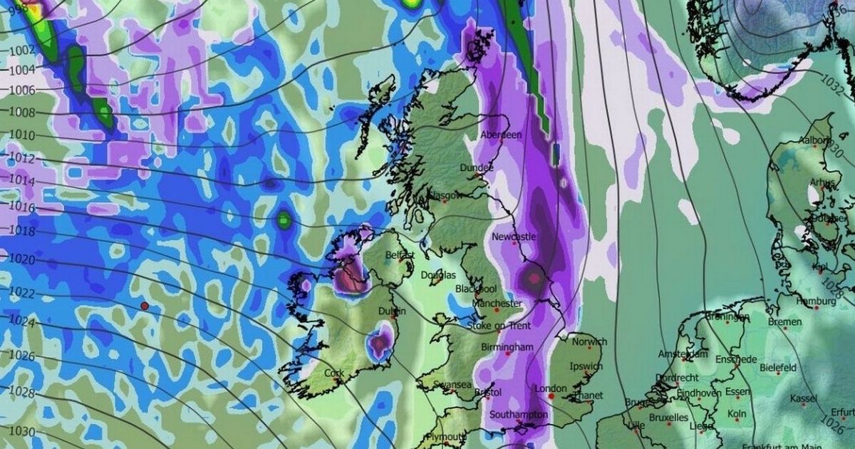
The weather forecasting maps reveal that widespread snow could be set for the North East before the end of January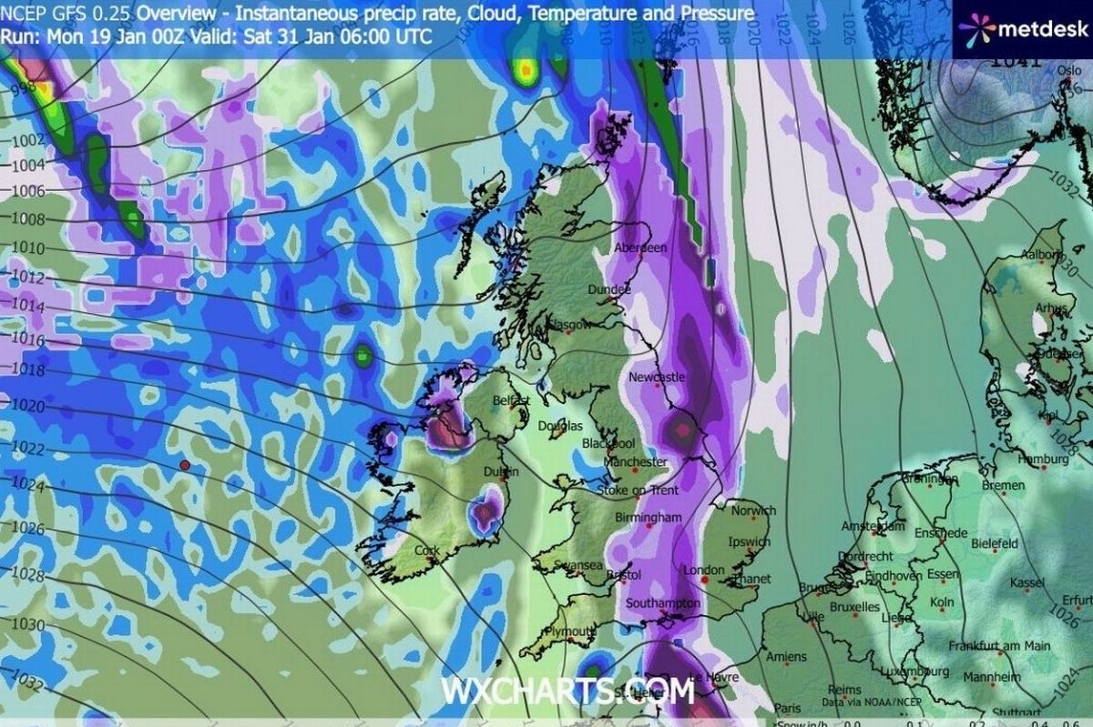
The weather map which shows a blizzard coming to the North East on January 31(Image: WX Charts)
Snow maps are showing twin blizzards which are set to bring up to 19 inches of the white stuff, burying 90% of the UK. Widespread snow could be set for the North East before the end of January, as the weather forecasting maps have revealed.
The advanced weather modelling maps show that the first storm sweeping across the UK will be on January 29, although the North East is not set to be majorly hit by the initial flurries. However, the snow will move eastward throughout the day, falling over the region by 9am.
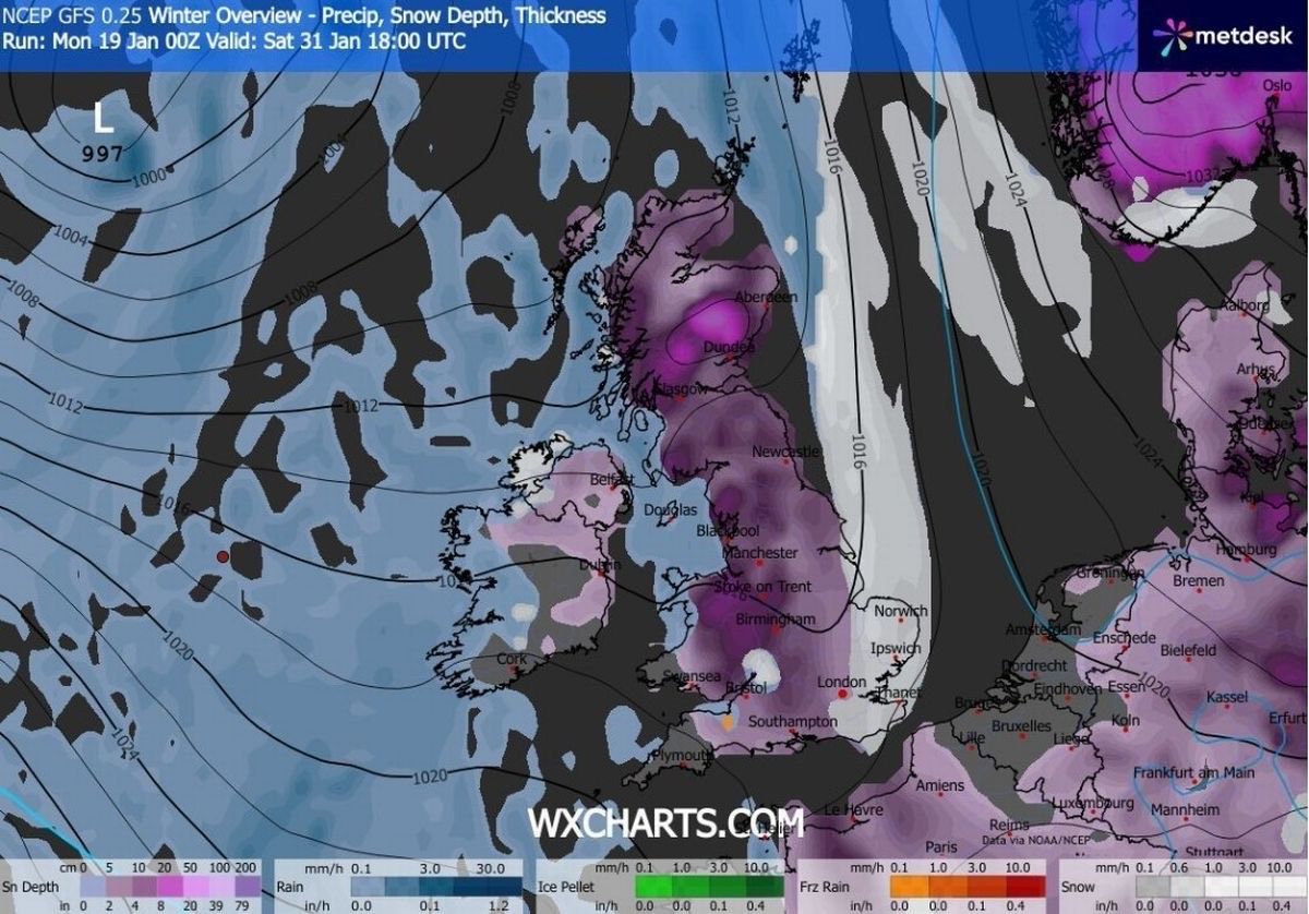
Another blizzard is then expected on January 30, with the map showing snow coming down at around 9pm. This is similarly expected to make its way eastward throughout the early hours of January 31, with further snow expected at around 6am, with the snow depth chart revealing that 12cm, or five inches, could settle in Northern England.
Charts reveal as much as 48cm (roughly 19 inches) could settle in the Scottish Highlands, with 15cm (six inches) in North Wales, and 7cm (three inches) possible in parts of southern England.
The Met Office forecast also suggests more snowfall before the end of the month, with the weather authority predicting the following for January 24 to February 2: “The UK will likely continue to sit in the battleground between Atlantic weather systems attempting to push in from the west, but tending to stall in the vicinity of the UK as they encounter high pressure to the north and northeast.
The weather map which shows a blizzard coming to the North East on January 31(Image: WX Charts)
“As such, further spells of rain or showers are likely at times, which may be heavy and persistent, especially in the south and west, with the best of any drier interludes in the far north and northwest.
“Whilst mild conditions will encroach into the south and west at times, it is likely to turn somewhat colder through this period, bringing the risk of some snow, more especially on hills in Scotland and northern England”.
The forecast for February 3 to February 17 adds: “Little overall change is expected in the weather patterns impacting the UK through much of this period, as Atlantic frontal systems attempt to push eastwards at times, but on a south-shifted storm track such that the wettest conditions are more likely in central and southern areas.
“North and north-western parts of the UK are most likely to be drier than normal. Whilst mild incursions are favoured at times in the south and west, colder conditions in the north and northeast will bring associated wintry hazards as wet weather attempts to spread in, especially on hills”.
Our ChronicleLive Daily newsletter is free. You can sign up to receive it here. It will keep you up to date with all the latest breaking news and top stories from the North East.
 Join our Breaking News and Top Stories WhatsApp community
Join our Breaking News and Top Stories WhatsApp community for all the latest news direct to your phone.
To join you need to have WhatsApp on your device. All you need to do is choose which community you want to join, click on the link and press ‘join community’.
No one will be able to see who is signed up and no one can send messages except the ChronicleLive team.
We also treat our community members to special offers, promotions, and adverts from us and our partners.
If you don’t like our community, you can check out any time you like. To leave our community click on the name at the top of your screen and choose ‘exit group’.
If you’re curious, you can read our privacy notice.