
Saturday, January 24, Morning Report
Now that the storm has taken form, we have a better handle on the development and impact for our region. The snow will not begin until after midnight, and we can expect impacts all day Sunday. The minor change I see is related to a stronger Low Pressure that will pull a little closer to us. This tendency to be a little more north and east will result in warmer air.
We all start with snow, and it will be heavy at sunrise on Sunday. Then a change to sleet and freezing rain will spread from south to north.
Places that stay with all snow will get more, and I see our inland suburbs reaching the higher end of my snow call, plus mixing of ice on top.
Heavier icing across Central Maryland and I-95 to Philadelphia and New York.
More rain is eventually expected on Delmarva.
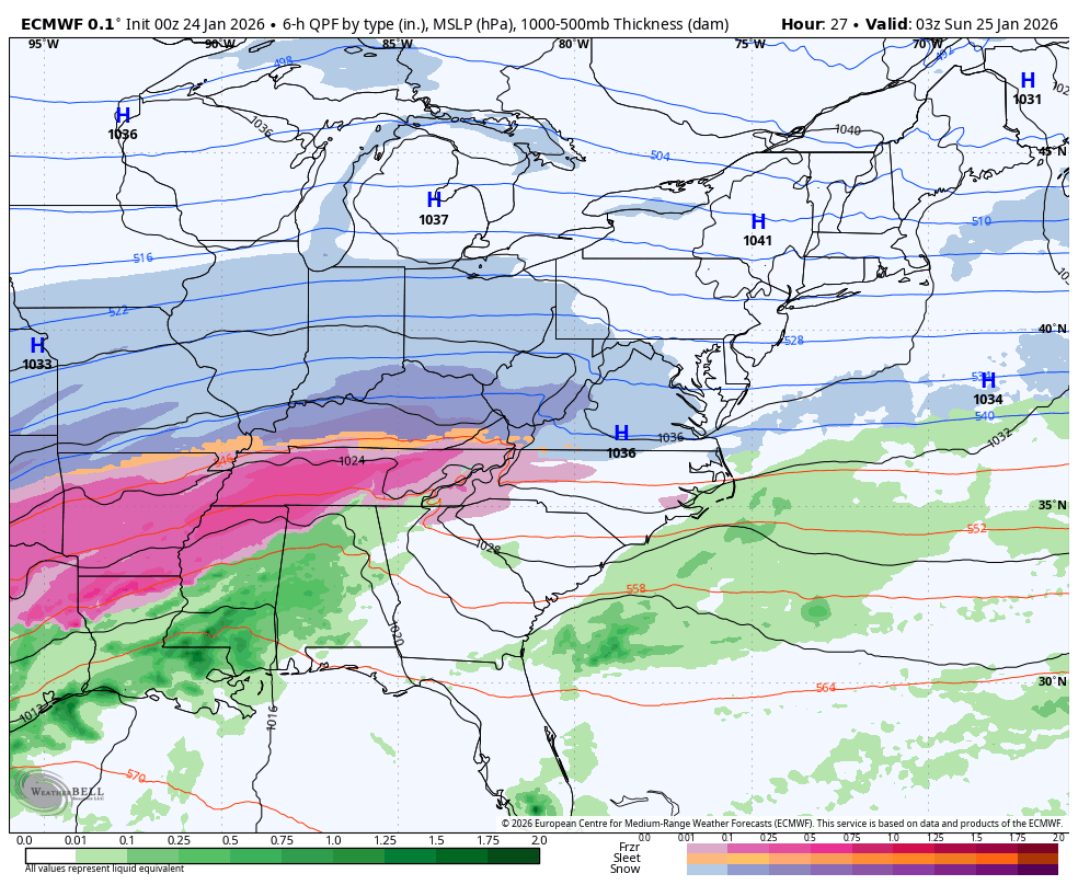
I have included several maps below to illustrate the timeline, compare the two models and their totals with mine.
STATE OF EMERGENCY
WINTER STORM WATCH
All six states have active declarations related to this storm. These allow for resource mobilization, emergency response coordination, and other preparations. Residents should follow local alerts, avoid unnecessary travel, and check official state emergency management sites for updates.
**Maryland**: Yes – Governor Wes Moore declared a State of Emergency (and requested federal assistance) due to expected heavy snow, ice, and sub-freezing temperatures.
**Pennsylvania**: Yes – Governor Josh Shapiro signed a Proclamation of Disaster Emergency for the commonwealth ahead of significant snowfall.
**Virginia**: Yes – Governor Abigail Spanberger declared a State of Emergency for severe winter weather expected to impact most of the commonwealth.
**Delaware**: Yes – Governor Matt Meyer declared a State of Emergency, effective starting Sunday morning (January 25, 2026), with the Emergency Operations Center activated.
**West Virginia**: Yes – Governor Patrick Morrisey declared a State of Emergency for all 55 counties ahead of the major winter storm.
**New Jersey**: Yes – Governor Mikie Sherrill declared a State of Emergency, effective at 5:00 p.m. on Saturday, January 24, 2026, for the severe winter storm.

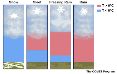
Snow Type:
While very cold temperatures will tend to result in dry and fluffy flakes, warmer air aloft will change that during the morning. So initially, the heavy snow will have higher ratios, but that will change. You will be able to tell by trying to make a snowball. If you can’t pack the snow, then the ratios will be high, and you are into the deep cold air.
If you can pack a snowball well, then the flakes will be more ‘damp’ or ‘wet’, which will compact more easily. This will be heavier to shovel as well.
If and when you see the flakes get VERY LARGE, that is a signal of warmer air aloft. The flakes will stick together and come down in clumps… Just before the change to sleet and or freezing rain.
Yes, we can get sleet and freezing rain with temps in the lower 20s. It all depends on a layer of warmer air between the clouds and the ground. Then how deep is the cold layer—deep enough for refreezing into ice pellets, or shallow enough for precipitation to stay liquid and freeze on contact?
This animation shows that with freezing marked by 0℃.
STORM MAPS
Morning Surface Weather
For Baltimore and the Mid-Atlantic: Cold and dry this morning as arctic air is locked in place. A State of Emergency has been declared ahead of tomorrow’s Winter Storm. Snow arrives late tonight!
State of Emergency: Maryland has declared a State of Emergency in preparation for the Winter Storm arriving tonight into Sunday. Take time today to prepare!
Arctic Air in Place: High pressure over the Great Lakes is keeping us cold and dry. This frigid air mass will be in place when the storm arrives, ensuring snow for our region.
The Storm is Coming: A large winter storm stretches from Kansas through Missouri, with snow on the northern edge, a dangerous freezing rain band through Oklahoma and Arkansas, and rain across Texas. This entire system is tracking toward the Mid-Atlantic.
Snow Heading Our Way: The snow band is pushing east through St. Louis and the Ohio Valley — this will reach us late tonight and continue through Sunday.
Freezing Rain Threat: The icy mix across the Southern Plains will be a major story. The northern edge of that freezing rain will determine if any ice mixes in for areas south of Baltimore.

Tonight
High Pressure will still keep our region dry through midnight. Then, snow will develop across the region and be heavy by daybreak Sunday.

Animation Tonight through Monday Morning
Local Look
Afternoon Temperatures

MOUNTAIN CAM:
WESTERN MARYLAND
This webcam is positioned at The Greene Turtle Deep Creek Lake and shows Wisp Resort, including a zoomed-in view of Squirrel Cage, The Face, the terrain park, Boulder, the mountain coaster, the tubing park and a shot of McHenry Cove at Deep Creek Lake!
CLIMATE DATA: Baltimore
Yesterday: Low 18°F; High 43°F
Precipitation: 0.00″
Season Snow Total: 2.4″
Snow Depth: 0″
Top Wind Gust: 40 mph
TODAY January 24
Sunrise at 7:20 AM
Sunset at 5:18 PM
Normal Low in Baltimore: 25ºF
Record Low: 1ºF in 1963
Normal High in Baltimore: 43ºF
Record High: 74ºF in 1967
Rainfall Deficit at BWI
Prior 2 Years (2024 + 2025) = -16.91″
Since Jan 1, 2026 = -1.19″
Big Snow Storm Pattern/History
Between 1979 and 2016 Baltimore averaged a 10”+ snowstorm every 2 to 4 years.
We have 3 of them in the winter 2009-2010
We had our largest storm in 2016.
Then the pattern broke.

Subscribe for email Alerts
Weather posts straight to your inbox
Sign up and be the first to know!
SUNDAY STORM DAY
Now we can look at High Resolution Models that have this in the time frame. I prefer the HRRR Model in this case. We will compare this to the European ECMWF to maintain consistency with the plots I’ve shown you over the past few days.
Where the mixing line sets up will make or break the snow total forecast. Also, adding anything more than 0.25″ of ice on top of the snow will lead to more likely power outages.
Radar Simulation Midnight to 11 PM

7 AM Snapshot
Heavy Snow will be falling at this time. We will need to watch the location and movement of the sleet and freezing rain to the south.

Morning Temperatures

AFTERNOON
1 PM
HRRR

ECMWF

4 PM Temperatures
This will play a key role in the mixing. Not only at the surface, but aloft.
Wind direction will also be monitored for how far inland the warmer air will mix.

HRRR

ECMWF

7 PM
HRRR

ECMWF

Sunday Night at 10 PM
HRRR

ECMWF
This will be done Monday morning, then we remain below freezing all week.

STORM TOTAL MAPS
My Updated Call For Snowfall
If I make any final updates, I will post them this afternoon

NEW NUMBERS MID DAY SATURDAY
MODEL MAPS
SNOWFALL
HRRR Model

ECWMF

Freezing Rain Forecast
HRRR Model

ECWMF

LOOKING AHEAD
Jet Stream
Another reinforcement of Arctic Air will keep us in the deep freeze all week.

Storm Forecast: Wednesday Morning to Thursday
At this time I see a small system with the potential for Light Snow on Thursday.

7-Day Forecast
Cold and dry today as arctic air locks in, then the Winter Storm arrives overnight into Sunday with 100% confidence.
The extended forecast is brutal: Highs only in the low 20s all week with lows in the single digits! Tuesday drops to 5°F.
Any snow that falls will stick around for days.
Faith In The Flakes!
Saturday: Cold and dry. High 21°F.
Sunday: ⚠️ WINTER STORM (100%). High 26°F, Low 18°F.
Monday: ⚠️ Flurries (30%). High 28°F, Low 21°F.
Tuesday: Mostly sunny. High 23°F, Low 5°F.
Wednesday: Mostly sunny. High 23°F, Low 7°F.
Thursday: Light snow (30%). High 20°F, Low 9°F.
Friday: Windy. High 22°F, Low 7°F.

Subscribe for email Alerts
Weather posts straight to your inbox
Sign up and be the first to know!
FAITH IN THE FLAKES STORE
NOW OPEN FOR THE SEASON

Snow Report December 14 and Grade My Forecast
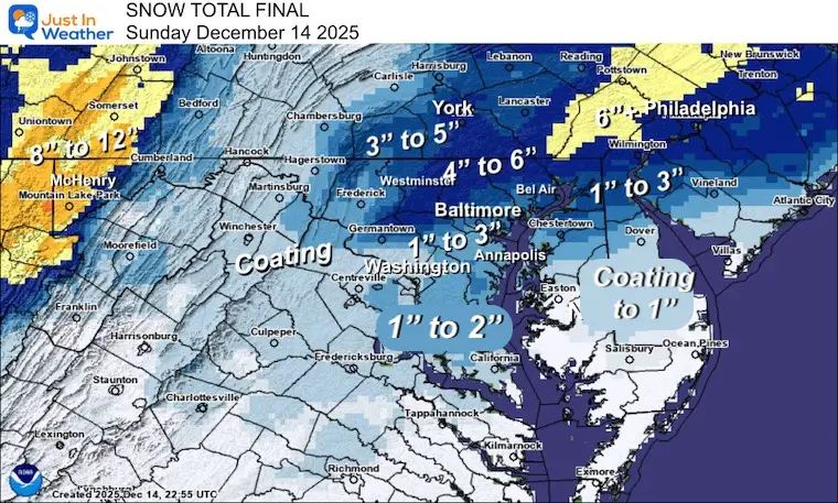
In case you missed it, click this image for brief summary of the final snow totals from the last event.
Snow Report December 5 to 6 and Grade My Forecast
In case you missed it, click this image for brief summary of the final snow totals from the last event.

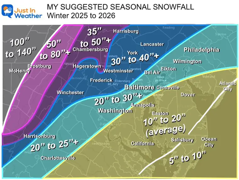
My Winter Outlook For Above-Average Snow
Click here for the full report
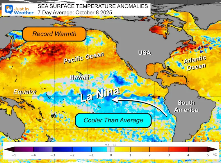
La Niña Advisory
This was issued October 9, as expected: A weak and short-lived event to start winter may play a different role this winter.
In Case You Missed It
Woolly Bear Caterpillar Winter Folklore
These are NOT all the same caterpillar!

Winter Outlook From 2 Farmers’ Almanacs

STEM Assemblies/In School Fields Trips Are Back
Click to see more and ‘Book’ a visit to your school

THANK YOU:
Baltimore Sun Magazine Readers’ Choice Best Of Baltimore

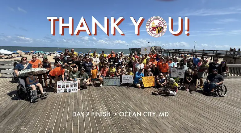
Maryland Trek 12 Day 7 Completed Sat August 9
UPDATED: We raised OVER $170,000 for Just In Power Kids – AND Still Collecting More
The annual event: Hiking and biking 329 miles in 7 days between The Summit of Wisp to Ocean City.
Each day, we honor a kid and their family’s cancer journey.
Fundraising is for Just In Power Kids: Funding Free Holistic Programs. I never have and never will take a penny. It is all for our nonprofit to operate.
Click here or the image to donate:
RESTATING MY MESSAGE ABOUT DYSLEXIA
I am aware there are some spelling and grammar typos and occasional other glitches. I take responsibility for my mistakes and even the computer glitches I may miss. I have made a few public statements over the years, but if you are new here, you may have missed it: I have dyslexia and found out during my second year at Cornell University. It didn’t stop me from getting my meteorology degree and being the first to get the AMS CBM in the Baltimore/Washington region. One of my professors told me that I had made it that far without knowing and to not let it be a crutch going forward. That was Mark Wysocki, and he was absolutely correct! I do miss my mistakes in my own proofreading. The autocorrect spell check on my computer sometimes does an injustice to make it worse. I can also make mistakes in forecasting. No one is perfect at predicting the future. All of the maps and information are accurate. The ‘wordy’ stuff can get sticky. There has been no editor who can check my work while writing and to have it ready to send out in a newsworthy timeline. Barbara Werner is a member of the web team that helps me maintain this site. She has taken it upon herself to edit typos when she is available. That could be AFTER you read this. I accept this and perhaps proves what you read is really from me… It’s part of my charm. #FITF
Please share your thoughts and best weather pics/videos, or just keep in touch via social media.