
The snow started late on Saturday night and intensified throughout Sunday morning.
COLUMBUS, Ohio — Everyone in central Ohio woke up to heavy snow on Sunday morning and watched it grow throughout the day.
The snow started late on Saturday night and intensified throughout Sunday morning. Snowfall is expected to continue throughout the day before tapering off late Sunday night or early Monday morning.
The region is expected to see anywhere between 8 to 14 inches of snow, with the southernmost counties expected to see the most amount.
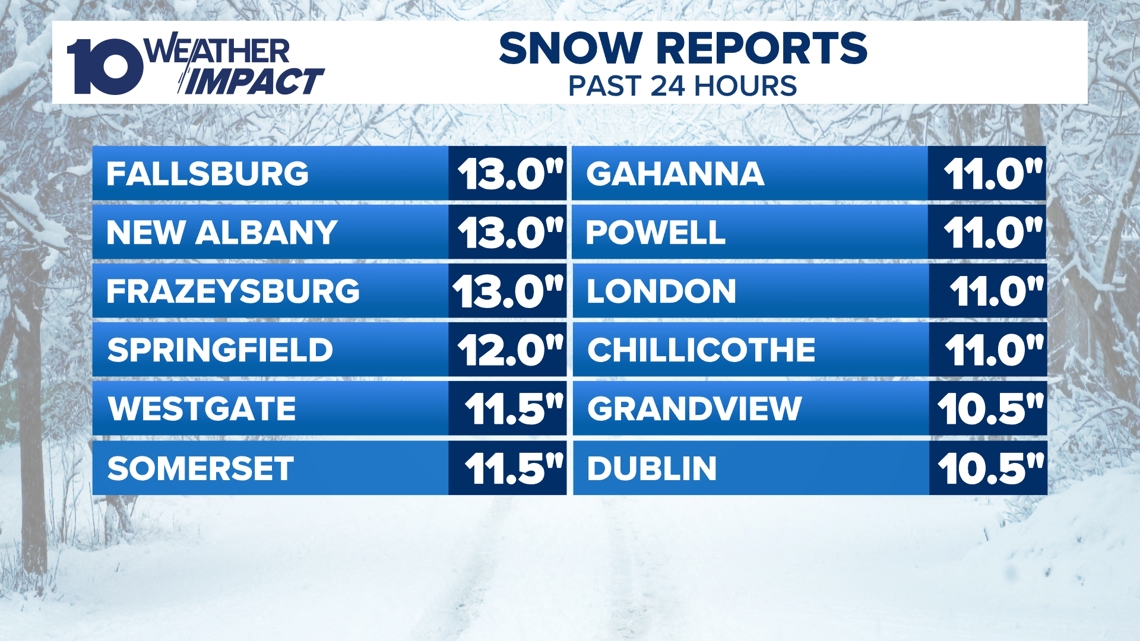
Here’s a list of reported snow amounts to the National Weather Service:
Bexley: 7 inches – 6:15 a.m.Canal Winchester: 6 inches – 8 a.m.Chillicothe: 3.3 inches – 5:44 a.m.Columbus: 7.5 inches – 8 a.m.Delaware: 7.4 inches – 9:30 a.m.Dublin: 5.2 inches – 7 a.m.Fallsburg: 13 inchesFrazeysburg: 13 inchesGahanna: 11 inches – 11 a.m.Grandview Heights: 9.6 inches – 7:15 a.m.Grove City: 8.5 inches – 11 a.m.Hilliard: 8 inches – 8 a.m.Lancaster: 6 inches – 12:42 p.m.London: 11 inches – 11:10 a.m.Marysville: 9.4 inches – 12:20 p.m.Marion County: 3.9 inches – 6:55 a.m.Minerva Park: 8.5 inches – 10:02 a.m.Mount Gilead: 3 inches – 7 a.m.Mount Vernon: 8 inches – 9:15 a.m.New Albany: 13 inches – 1:15 p.m.Powell: 5.5 inches – 8 a.m.Reynoldsburg: 7.5 inches – 12 p.m.Springfield: 12 inchesSunbury: 7 inches – 7:45 a.m.Upper Arlington: 8 inches – 8 a.m.West Jefferson: 9.5 inches – 7:45 a.m.Whitehall: 10.2 inches – 1 p.m.Worthington: 9 inches – 12:30 p.m.
This is most of the snow accumulation as the snow tapers off this evening. Some more light accumulation is still possible through early tonight.
Several Ohio counties are under a Snow Emergency, with Franklin County under a Level 3. A full list of Snow Emergencies can be seen here.
Extended forecast
A major winter storm is ongoing across the central, southern and eastern United States for the upcoming weekend. Central Ohio could see up to 14″ of snow this weekend from the storm.
The National Weather Service has issued a Winter Storm Warning for all 88 Ohio counties. This also extends across several states from New Mexico and Texas to the Carolinas on up into New York and Vermont.
Things to know:
Much of the Columbus metro area could see between 8 and 14 inches of snow. Some parts of southern Ohio may pick up more than a foot of snowfall.A Winter Storm Warning is in effect for central Ohio counties until 12 p.m. Monday.Snow will continue through Sunday night. The further south you go, the greater the accumulation, until you hit a line from Chillicothe to Logan, where some mix may lower totals.Snow, wind, and cold temperatures will make for difficult travel conditions. Get traffic updates here.Several counties are under snow emergencies. Get the full list and what the levels mean here.Some buildings and businesses are also closed because of the weather. Get the updated list here.
How much snow is expected in central Ohio?
The 10 Weather Impact team has updated the snowfall forecast to bring some of the heavier snowfall further north. Once all is said and done by Monday morning, 8-14″ of snow appears likely for the Columbus metro and much of central Ohio. There is likely to be a few spots that overachieve from this system, and could land over the 14 inch mark!
Anticipate steady, heavier snowfall overnight and through Sunday.
This has the potential to be one of, if not the biggest, snowfalls we get this season. If we get over 12 inches of snow, this will be a top-five snow event for the Columbus region ever.
How cold will it be this weekend?
In addition to the snow, single-digit and even subzero temperatures are expected for the next week, potentially through the end of January. This drop in temperatures will again bring widespread and prolonged subzero wind chills to the whole region.
Wind chill values will likely be within the -10 to -20 range most of Monday morning and especially Tuesday morning. Sub-zero morning wind chills will remain likely for at least the next 7 days. Along with this, each of the next 7-days will remain under a Weather Impact Alert for the extreme cold.