
A rapidly strengthening storm is building off the East Coast. But whether Massachusetts is hit by snow on Sunday will depend on a few miles of storm track.
This storm — a so-called “winter hurricane” or bomb cyclone — is poised to become a powerhouse. It’s tapping into multiple sources of upper-level energy: one flowing from the Pacific, the other diving down from Canada. As these bundles of energy merge, the developing low-pressure system will explode in intensity well offshore, south and east of New England.
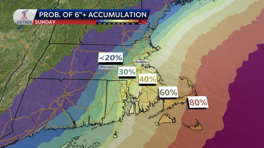
Four days out from the storm, the highest chance of heavy snow is in southeastern Massachusetts, the Outer Cape and Nantucket. Those areas are facing half a foot of snow to upwards of 12 inches, if the storm nudges closer.
In Boston, the chance of getting 6 inches of snow or more is currently around 30%, with odds dropping sharply north and west of the city. But a shift of even 10 to 20 miles in the storm’s path could spell the difference between meaningful snow or little if anything.
How this will impact the coast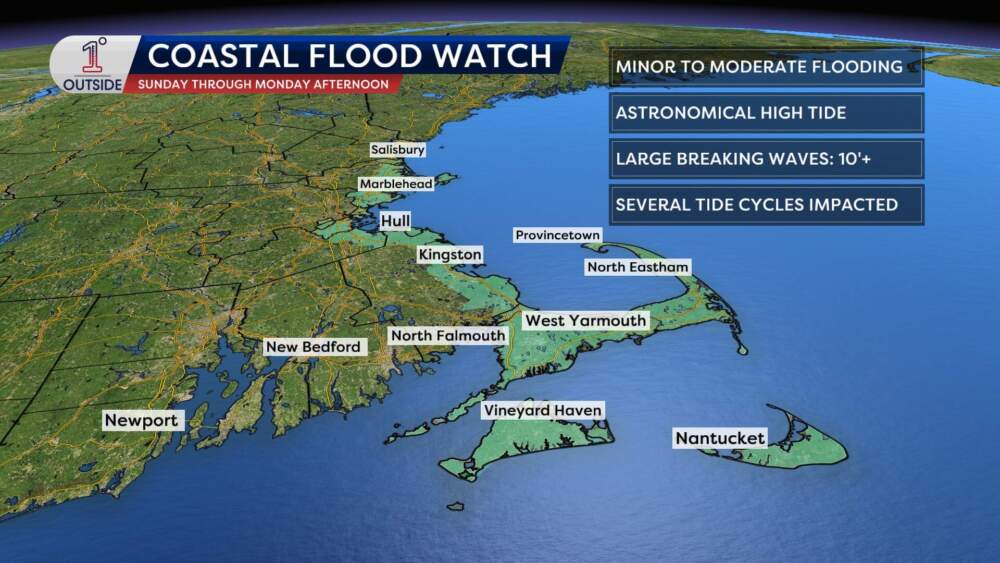 The areas under coastal flood watch beginning Sunday, Jan. 30, 2026. (Danielle Noyes/1DegreeOutside)
Coastal impacts are a big concern with this storm. With a full moon this weekend, astronomical tides will already be running high. Combined with northeast winds pushing water towards the shore, coastal flooding becomes a real concern.
Expect minor to moderate coastal flooding for vulnerable shorelines, particularly on the Cape and South Shore. Large breaking waves of 10 to 20 feet offshore will also cause erosion.
Peak wind gusts may reach 50 to 60 mph on Nantucket and the Outer Cape, with gusts of 40 to 50 mph possible along parts of Essex County and the South Shore. Elsewhere, wind will be lighter — in the 20 to 30 mph range — but still enough to add a bite to the already bitter cold.
 Estimated maximum wind gusts for the storm from Sunday into Monday. (Danielle Noyes/1DegreeOutside)
It’s worth noting that a “core” of hurricane-force wind gusts is likely to stay offshore. But the Outer Cape to Nantucket could see some 60 to 70 mph gusts, depending on track. If that’s the case, then outages and damage will result.
What we know for sure ahead of the storm
Before flakes begin to fall, brace for a deep freeze. Temperatures will plummet below zero in many spots Thursday and Friday night, with wind chills between -10 and -20. Saturday will stay cold, with highs in the teens and wind chills in the single digits.
With so much uncertainty in the track of the storm, it’s premature to release a snowfall map for New England. But the forecast is more certain for the Carolinas and southeast U.S., where the “jackpot” will drop 8 or more inches, possibly crippling those areas for days.
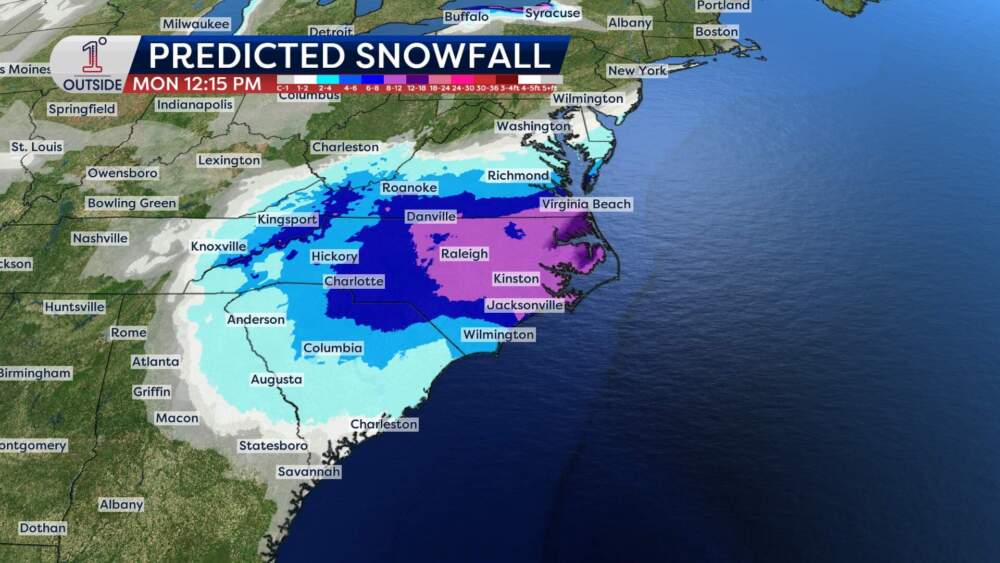 The expected snow accumulation in the Carolinas by Monday, Feb. 1, 2026. (Danielle Noyes/1DegreeOutside)The bottom line
This is not a “cancel your plans” forecast for Sunday yet. But it is a situation that demands attention. Here are the key takeaways:
If the storm passes farther offshore, Boston and much of interior Massachusetts may see nothing more than a few flakes and gusty breezes. If the storm tracks just 20 miles closer, southeastern Massachusetts, the Cape and Islands could get a half-foot or more of heavy snow, with blizzard conditions, coastal flooding and power outages in the mix.
The pieces are on the board. It’s the final placement that will decide the outcome.
Get the latest storm updates at 1DegreeOutside.com or on the free 1DegreeOutside mobile app.