
While Saturday’s storm is unlikely to crack the top five overall, Brad Panovich noted it could still make the record books for single-day snowfall totals.
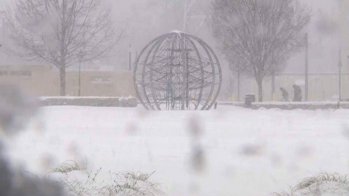
CHARLOTTE, N.C. — Charlotte is experiencing a significant winter storm that could secure a place among the city’s most historic snowfall events, according to Weather Impact Chief Meteorologist Brad Panovich.
As of Saturday evening, double-digit snow totals were beginning to appear across the region, particularly north of Charlotte, raising the possibility that the storm could break into the top 10 all-time snow events for the city. As of 9:14 p.m., Charlotte received 6.1 inches at the airport, where official measurements are recorded.
“We’ve got some 10-inch totals beginning to show up, especially north of Charlotte,” Panovich said on WCNC+. “If we get to 10 inches, that’s gonna put us in the top 10 all-time snow event from a 24-hour standpoint.”
The meteorologist projected final totals could reach 8 to 9 inches, with some areas receiving higher accumulation.
Official totals from the National Weather Service included nine inches of snow in Davidson, five inches in Mint Hill and Matthews, eight inches near Belmont and Maiden, and 14.5 inches in Kannapolis.
Historic context
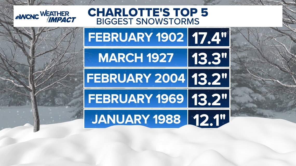
The potential significance of this snowfall becomes clear when compared to Charlotte’s snowiest storms on record. The city’s top five snowstorms include:
January 1902: 17.4 inchesMarch 1927: 13.3 inchesFebruary 2004: 13.2 inches (over two days)February 1969: 13.2 inchesJanuary 1988: 12.1 inches

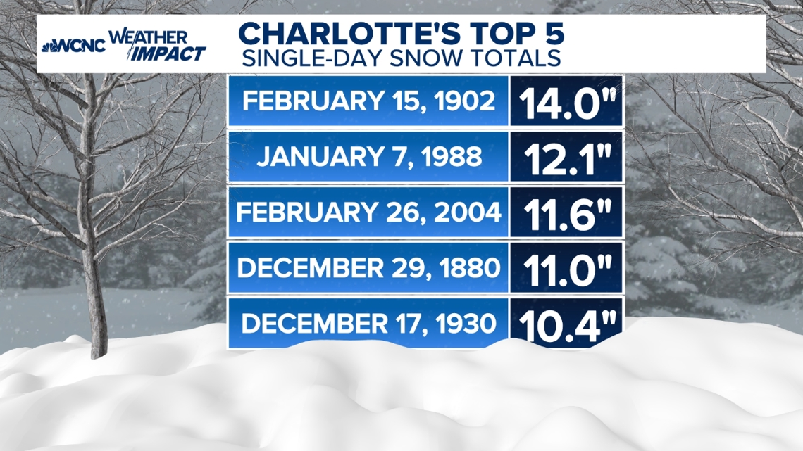
Those totals are for complete snowstorms, not single-day events. While Saturday’s storm is unlikely to crack the top five overall, Panovich noted it could still make the record books for single-day snowfall totals. Weather Impact meteorologist Brittany Van Voorhees compiled the five biggest single-day snow totals in Charlotte’s history:
Feb. 15, 1902: 14.0 inchesJan. 7, 1988: 12.1 inchesFeb. 26, 2004: 11.6 inchesDec. 29, 1980: 11.0 inchesDec. 17, 1930: 10.4 inches

“We’re probably not gonna make the top 5 for snowstorms, but for daily snowfall, we likely will make that because you only got to get to 10 [inches],” Panovich said.
A decade’s worth of snow in one day
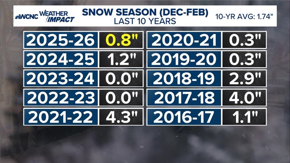
Perhaps most striking is how this single storm compares to recent winters in Charlotte. The last 10 years have averaged just 1.7 inches of snow per season, making Saturday’s snowfall extraordinary by recent standards.
“You could add up all the last 10 years and it doesn’t even equal the snow we got today in some places,” Panovich said. “That shows how much snow we had.”
The region would need to look back to 2010 to find a season that produced as much snow as this single event. Prior to this weekend’s snowstorm, Charlotte had received 0.8″, all of which was recorded during last weekend’s ice storm. Panovich noted that sleet technically counts as snow in the record books.

Dangerous Cold to Follow
Beyond the snow, dangerously cold temperatures are expected to follow the storm. Overnight lows on Monday morning could drop into the single digits area-wide.
“We have not been a single digit since Christmas 2022,” Panovich said, referencing the last time Charlotte saw such extreme cold.
You have to go all the way back to December 2014 to find an overnight low temperature of 7 degrees, which is the forecast low on Monday. Panovich advised residents to clear snow from vehicles and driveways Saturday evening before temperatures plummet.