
Monday February 2, Morning Report
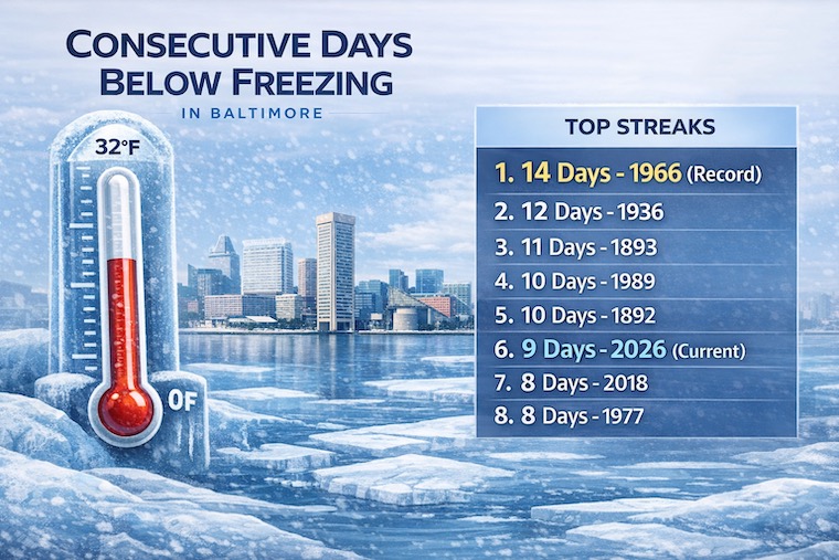
Our streak of days below freezing in Baltimore is about to come to an end, briefly. The forecast has us close today, and if BWI holds at 32F or colder, then it will definitely be broken tomorrow. That is purely conversational. We have two hits of light snow this week and another push of polar air this weekend.
Today is Groundhog Day. The live stream from Punxsutawney PA, is below. The main event and his call will be at 7:15 AM. I should note that this tradition began in 1887. On this 140th Anniversary, his accuracy is 39%, which is lower than flipping a coin. But this is all in good fun and a big party in a small town.
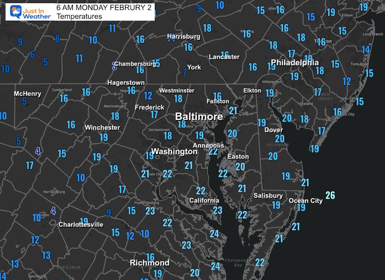
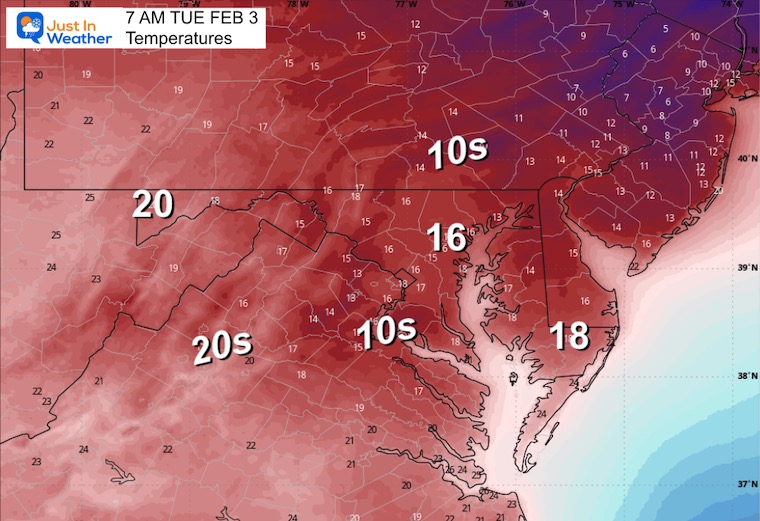
Local Morning Temperatures
BLOWOUT FROZEN TIDE
As expected and advised, the low water and ice build up has led to problems on the Chesapeake Bay this weekend. Yes, many unprepared boats will be damaged. Docks and boat slips may suffer further when the water comes back, along with the thaw.
FROZEN BAY
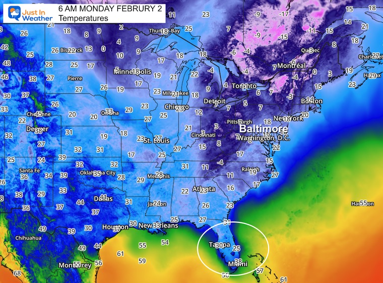
Eastern US
Temperatures
The Deep Freeze has reached much of Florida. Coastal areas are holding the line.
Tampa = 30℉
Miami = 38℉
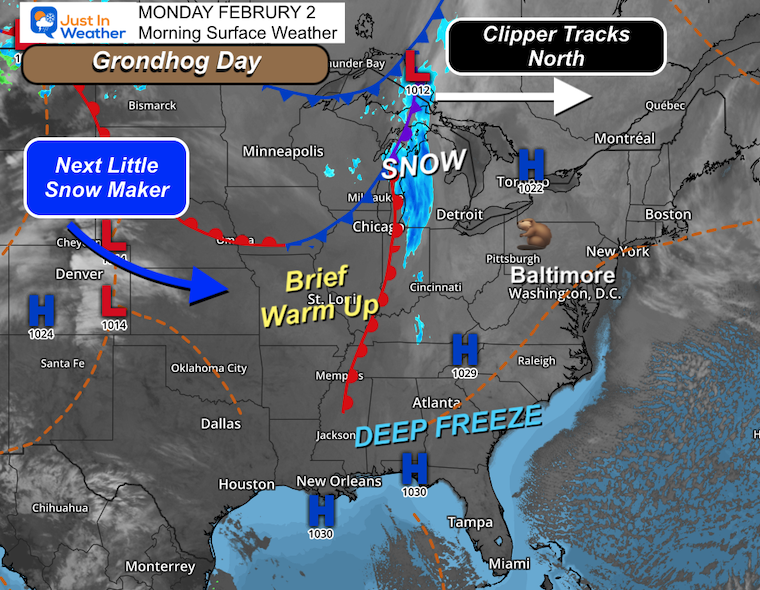
Morning Surface Weather
Sunny and Cold Start: High pressure (1029 mb) is in control over the Mid-Atlantic, keeping skies clear. Baltimore is sunny and cold, but the brutal single-digit lows are behind us for now.
Deep Freeze Continues South: High pressure (1030 mb) anchored over the Gulf Coast keeps cold air locked in from Mississippi to the Carolinas. The prolonged cold outbreak continues across the Southeast.
Clipper Tracks North: A clipper system is tracking across southern Canada near Thunder Bay. This keeps the snow well to the north through the Great Lakes region today, with a band of snow from Minnesota through Wisconsin and Michigan.
Brief Warm Up: A warm front is pushing north through the Mississippi Valley near St. Louis. This will nudge our temperatures slightly higher on Tuesday, reaching the mid 30s — still well below normal but a welcome break from the deep freeze.
Next Little Snow Maker: A developing low-pressure system near Denver (1014 mb) is the next system to watch. This will track eastward and could bring light snow to the region by Tuesday night.
Quick Forecast: Through Wednesday Morning
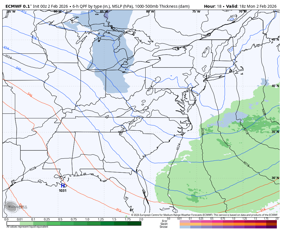
The next disturbance will bring light snow Tuesday Night and Wednesday Morning. This will end by sunrise, but may add a dusting to 1 inch in its path.
Local Forecast
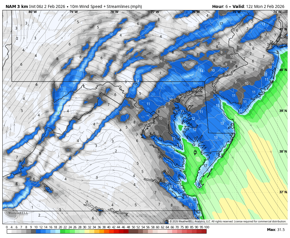
Wind Forecast
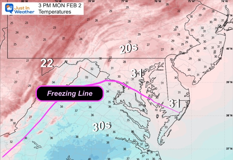
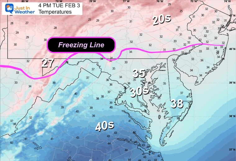
Afternoon Temperatures
The freezing line will be close, and it may make it to Baltimore this afternoon with just one more degree…
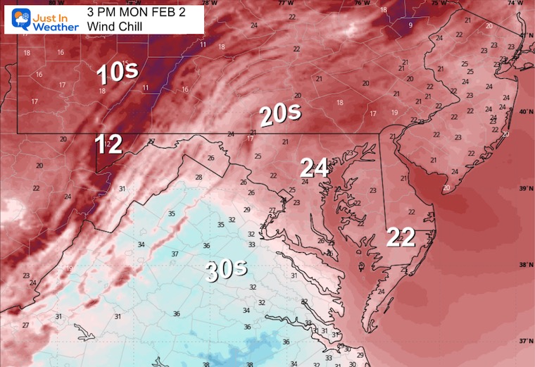
Wind Chills
MOUNTAIN CAM:
WESTERN MARYLAND
This webcam is positioned at The Greene Turtle Deep Creek Lake and shows Wisp Resort, including a zoomed-in view of Squirrel Cage, The Face, the terrain park, Boulder, the mountain coaster, the tubing park and a shot of McHenry Cove at Deep Creek Lake!
Streak Of Days Staying Below Freezing
CLIMATE DATA: Baltimore
Yesterday: Low 13°F; High 26°F
Precipitation: 0.00″
Snow Depth: 7″
Season Snow Total: 13.7″
Top Wind Gust: 32 mph
TODAY February 2
Sunrise at 7:12 AM
Sunset at 5:29 PM
Normal Low in Baltimore: 25ºF
Record Low: 1ºF in 1961
Normal High in Baltimore: 44ºF
Record High: 71ºF in 1967
Rainfall Deficit at BWI
Prior 2 Years (2024 + 2025) = -16.91″
2026 YTD = -0.31″
TUESDAY
Slightly warmer air will flow in thanks to that clipper passing north and before the next push of snow.
Morning Temperatures
Afternoon Temperatures
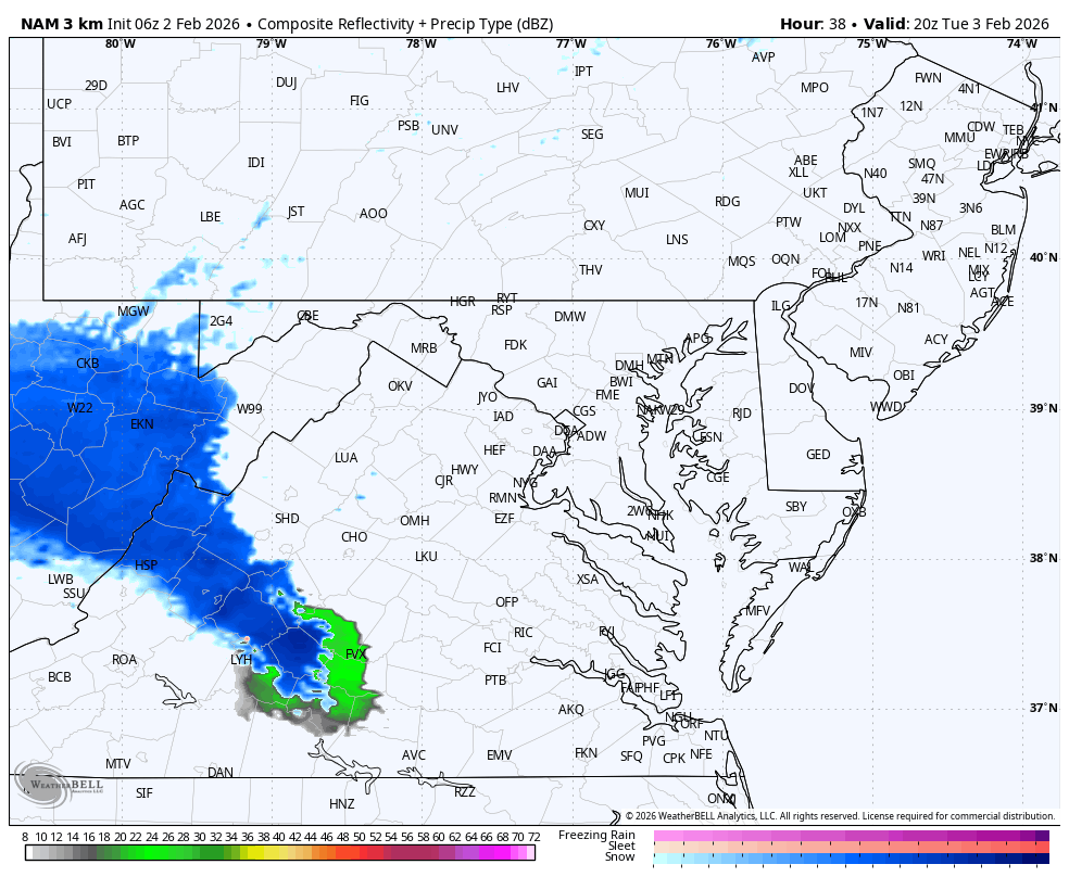
Radar Simulation: NAM 3Km
3 PM To Midnight
Light snow showers may develop from the afternoon….sunset to midnight.
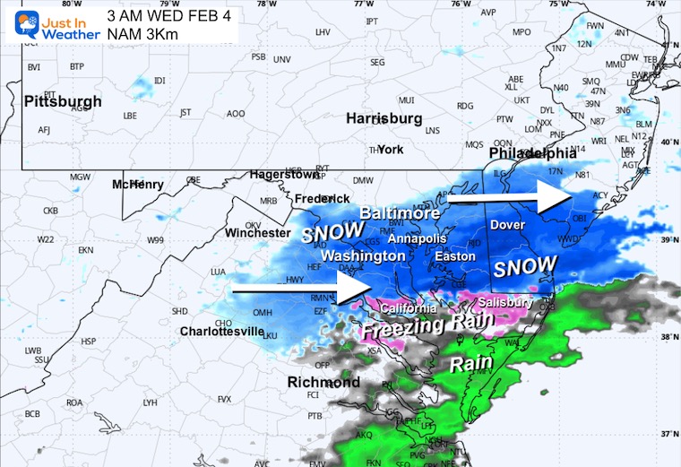
WEDNESDAY MORNING
Radar Simulation: NAM 3Km
Midnight to 1 PM
This will be an early morning event and will be done by sunrise.
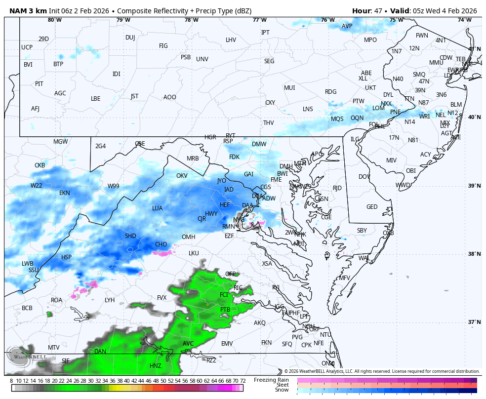
Snapshot at 3 AM
It will be cold enough that whatever falls will stick.
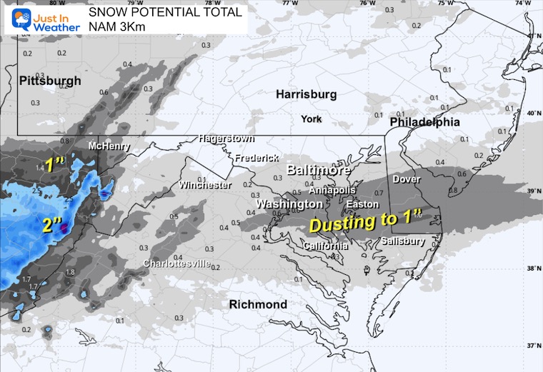
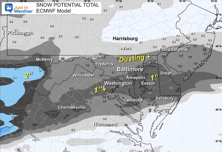
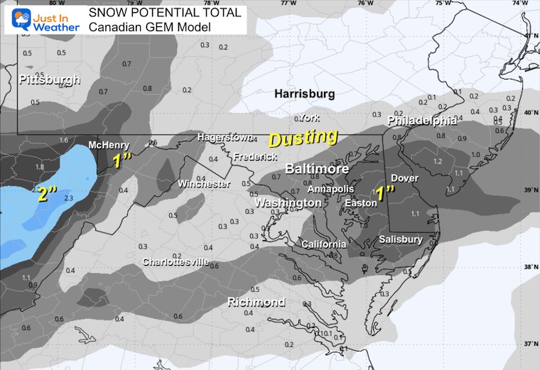
The most we can expect is a dusting to around 1 inch in the direct path.
Snowfall Potential: Model Forecast
NAM 3Km
European ECMWF
Canadian GEM
Looking Ahead:
Wednesday to Friday Evening
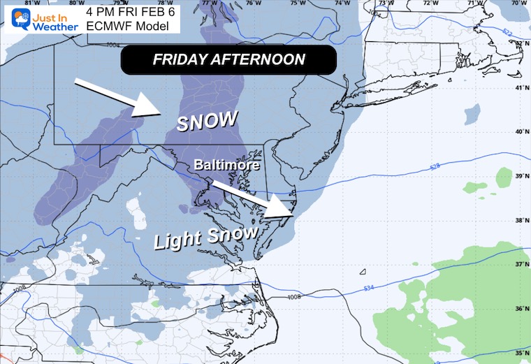
The next clipper will arrive Friday afternoon and evening. This will bring a better chance for some snow stickage and minor accumulation from the North.

Friday Afternoon
This may have a little more impact and affect your plans to start the weekend.
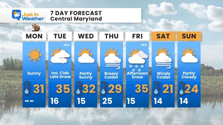
7-Day Forecast
Monday: Sunny. High 31°F.
Tuesday: Increasing clouds, late snow (40%). High 35°F, Low 16°F.
Wednesday: Partly sunny. High 32°F, Low 15°F.
Thursday: Breezy and colder. High 29°F, Low 25°F.
Friday: Afternoon snow (50%). High 35°F, Low 15°F.
Saturday: Windy and colder. High 21°F, Low 14°F.
Sunday: Partly cloudy. High 24°F, Low 14°F.
Subscribe for email Alerts
Weather posts straight to your inbox
Sign up and be the first to know!
FAITH IN THE FLAKES STORE
NOW OPEN FOR THE SEASON

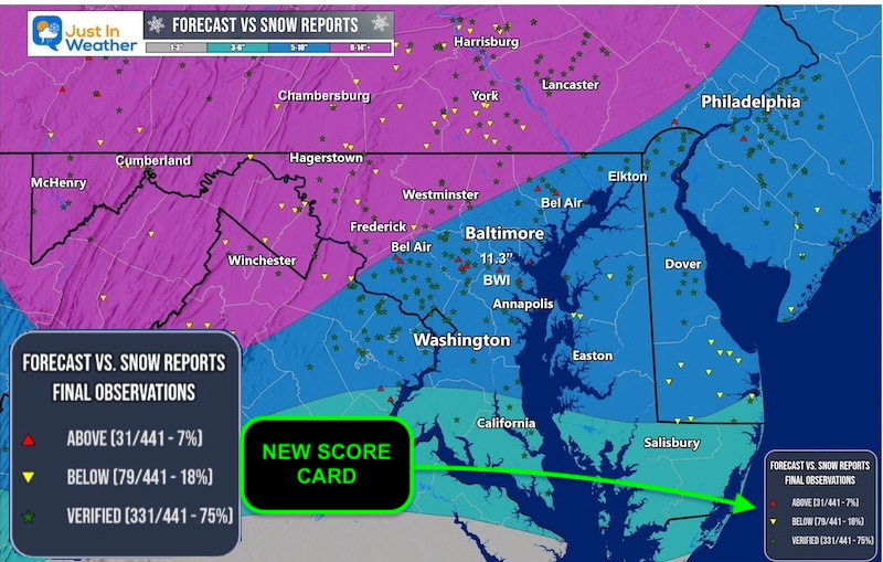
January 25 Snow Report AND Grade My Forecast
Click here to see the full report
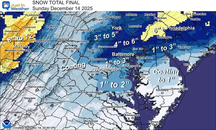
Snow Report December 14 and Grade My Forecast
In case you missed it, click this image for brief summary of the final snow totals from the last event.
Snow Report December 5 to 6 and Grade My Forecast
In case you missed it, click this image for brief summary of the final snow totals from the last event.

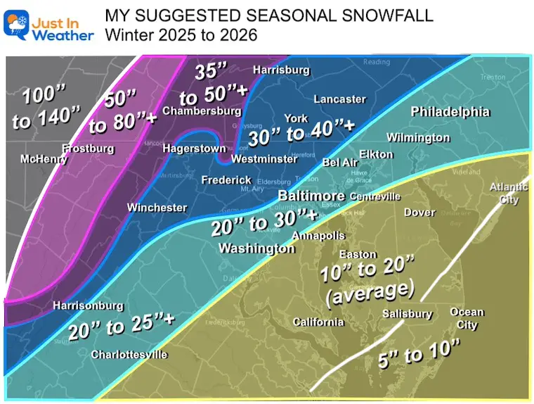
My Winter Outlook For Above-Average Snow
Click here for the full report
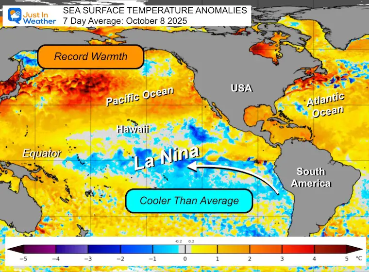
La Niña Advisory
This was issued October 9, as expected: A weak and short-lived event to start winter may play a different role this winter.
In Case You Missed It
Woolly Bear Caterpillar Winter Folklore
These are NOT all the same caterpillar!

Winter Outlook From 2 Farmers’ Almanacs

STEM Assemblies/In School Fields Trips Are Back
Click to see more and ‘Book’ a visit to your school

THANK YOU:
Baltimore Sun Magazine Readers’ Choice Best Of Baltimore

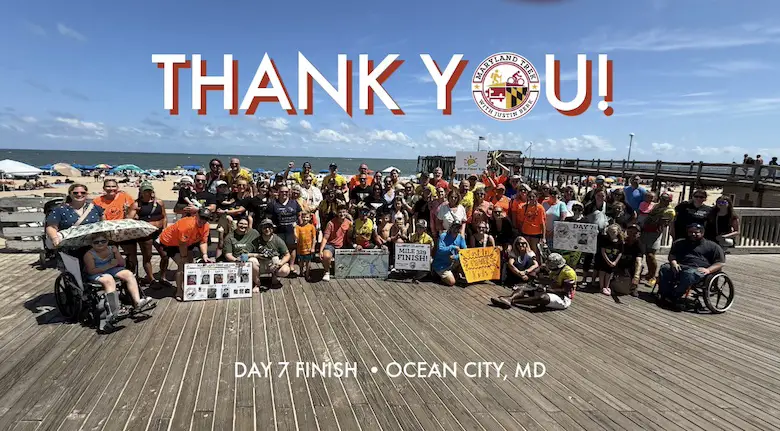
Maryland Trek 12 Day 7 Completed Sat August 9
UPDATED: We raised OVER $170,000 for Just In Power Kids – AND Still Collecting More
The annual event: Hiking and biking 329 miles in 7 days between The Summit of Wisp to Ocean City.
Each day, we honor a kid and their family’s cancer journey.
Fundraising is for Just In Power Kids: Funding Free Holistic Programs. I never have and never will take a penny. It is all for our nonprofit to operate.
Click here or the image to donate:
RESTATING MY MESSAGE ABOUT DYSLEXIA
I am aware there are some spelling and grammar typos and occasional other glitches. I take responsibility for my mistakes and even the computer glitches I may miss. I have made a few public statements over the years, but if you are new here, you may have missed it: I have dyslexia and found out during my second year at Cornell University. It didn’t stop me from getting my meteorology degree and being the first to get the AMS CBM in the Baltimore/Washington region. One of my professors told me that I had made it that far without knowing and to not let it be a crutch going forward. That was Mark Wysocki, and he was absolutely correct! I do miss my mistakes in my own proofreading. The autocorrect spell check on my computer sometimes does an injustice to make it worse. I can also make mistakes in forecasting. No one is perfect at predicting the future. All of the maps and information are accurate. The ‘wordy’ stuff can get sticky. There has been no editor who can check my work while writing and to have it ready to send out in a newsworthy timeline. Barbara Werner is a member of the web team that helps me maintain this site. She has taken it upon herself to edit typos when she is available. That could be AFTER you read this. I accept this and perhaps proves what you read is really from me… It’s part of my charm. #FITF
Please share your thoughts and best weather pics/videos, or just keep in touch via social media.