
There is a major weather pattern change underway across the U.S. As we get into next week, the storm track looks really interesting.
Major upper-air pattern changes are quite normal. Sometimes we have a very consistent weather pattern across part of the northern hemisphere. We’ve all endured harsh winter weather in the eastern U.S. over the past few weeks. This strong winter pattern is brought about by a stubborn lobe of the Polar Vortex rotating around the Great Lakes, Northeast and southeastern Canada.
One more blast of Arctic cold is going to occur this weekend over Michigan and the Northeast, then the Polar Vortex is going to slip back north to its home, surrounding the North Pole.
The movement of the Polar Vortex is just one piece of the weather pattern juggling going on over the next week. As the Polar Vortex lifts north, a colder, stormier bend in the jetstream will form over the West Coast. This bend in the storm track out west will result in what we call a “ridge” in the jetstream over the eastern U.S., including Michigan.
A ridge aloft is a warmer pattern. Notice I didn’t say warm. I will let you decide if temperatures in the 30s and 40s are warm at this time of year. It’s definitely a warmer pattern, as we will go from below-zero recently to a few days around 40 degrees over the Great Lakes next week.
With the new flow comes not only warmer temperatures, but also more moisture-laden storm systems for Michigan and the Great Lakes region. I’d say the entire eastern U.S. is going to get into more robust storm systems in the next two weeks, but those in the Carolinas and Mid-Atlantic have already been smothered in snow and ice with the last two storms.
With 37 years of experience looking at weather maps, I look at the developing upper-air pattern and one word keeps coming to my mind – wonky.
It won’t be an alarming weather pattern, especially since we finally get some melting after over a week below 16 degrees for many Michigan cities. It will be a weather pattern with multiple medium-strength storm systems coming at us over the next two weeks.
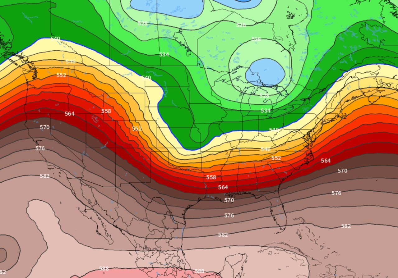
Watch the wonky upper-air pattern develop with me. Here’s the upper-air forecast at 15,000 feet up, from this weekend to mid-February. The Polar Vortex will dive into the Northeast this weekend, and then quickly move northeast, off the map. Storm systems will dive into the West Coast, and then travel across the central U.S. These storm systems will come at Michigan, the Great Lakes region and the Northeast with more moisture than the Arctic dry Alberta Clippers of the past month.
 Upper-air flow forecast from Friday, February 6 to Thursday, February 19.NOAA
Just stare at the flow for mid-February. There are several “bends” in the jetstream. Each one of these bends is a storm system that produces snow, freezing rain or rain.
So what does this all mean for us in Michigan?
The Arctic air, dominant over our state in the last month, will move out. We will warm up, for at least two weeks. By warm-up, I mean we will have many afternoons warming to between 32 degrees and 42 degrees. I’ll let you decide if that’s “warm.”
With so many storm systems, each storm won’t be able to become a blockbuster storm. We could have several small to medium strength winter storms. We still have to call them winter storms since the north side of the storm will have several inches of snow, or sleet and freezing rain.
Do you remember the lava lamp from the 1970s? We turned the heat light on under the red, gooey stuff. The bubbles of hotter blobs started moving to the top of the lamp in a rhythmical fashion. At some point one of the blobs moving down from the top hit a blob moving up, and the whole pattern went wonky.
That’s what is happening next week.
In this case, if you want milder temperatures, you will like this wonkiness. If you don’t want much precipitation, you may not like the new weather pattern.
You are probably wondering if we are done with the Polar Vortex coming this far south again this winter. The Polar Vortex is going to move over to the other side of the globe for the next two weeks. It could slingshot back over the North Pole and head our way again after two weeks. That timing puts us at almost March. Sure, it can get cold in March, but it won’t likely be Arctic cold.
If you have spring fever, time is almost on your side now.
In fact, historical weather data shows why this week is the first step toward spring.
My motto currently is, “It’s just a waiting game now.”
Make sure to stay updated with any of these storm systems in the wonky flow at MLive.com/weather.
Here’s my MLive Morning Weather update. I show you more about the current weather pattern change we are undergoing.