

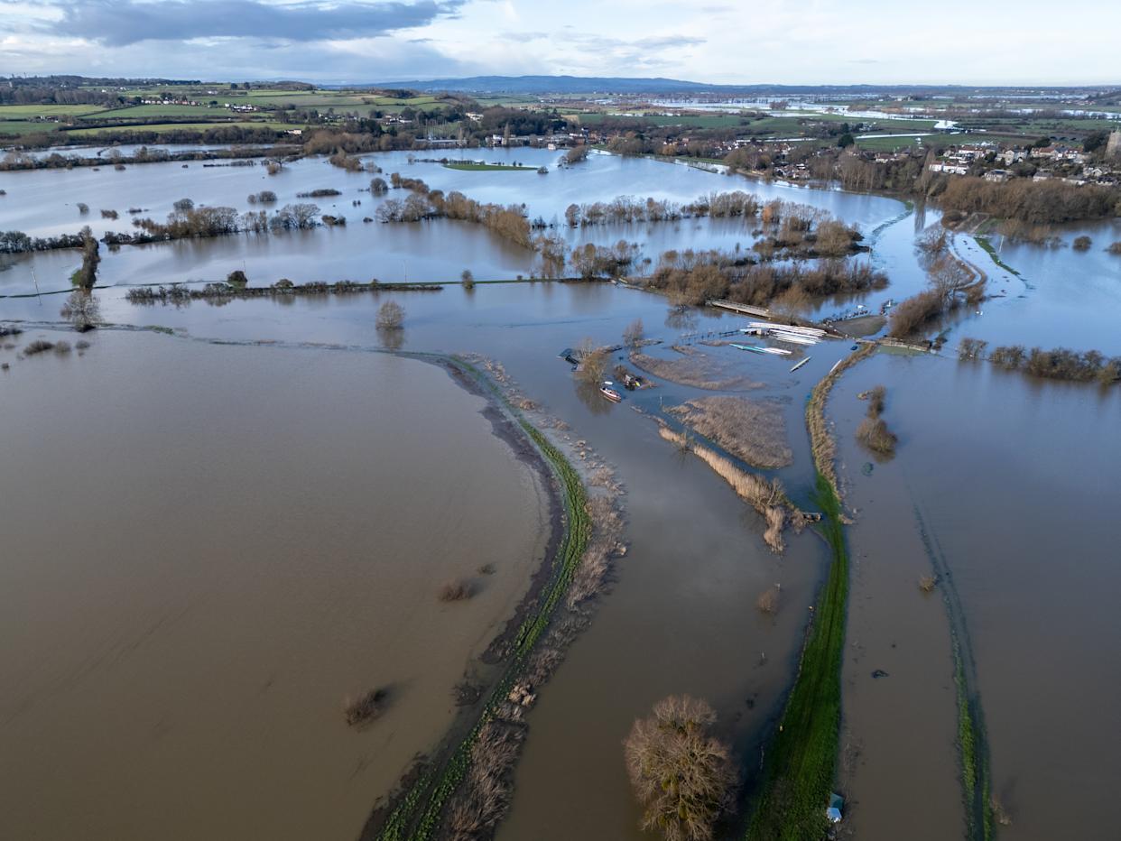
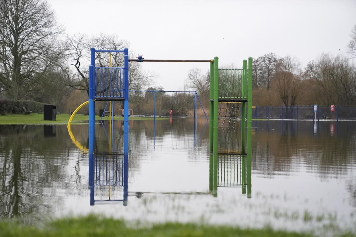
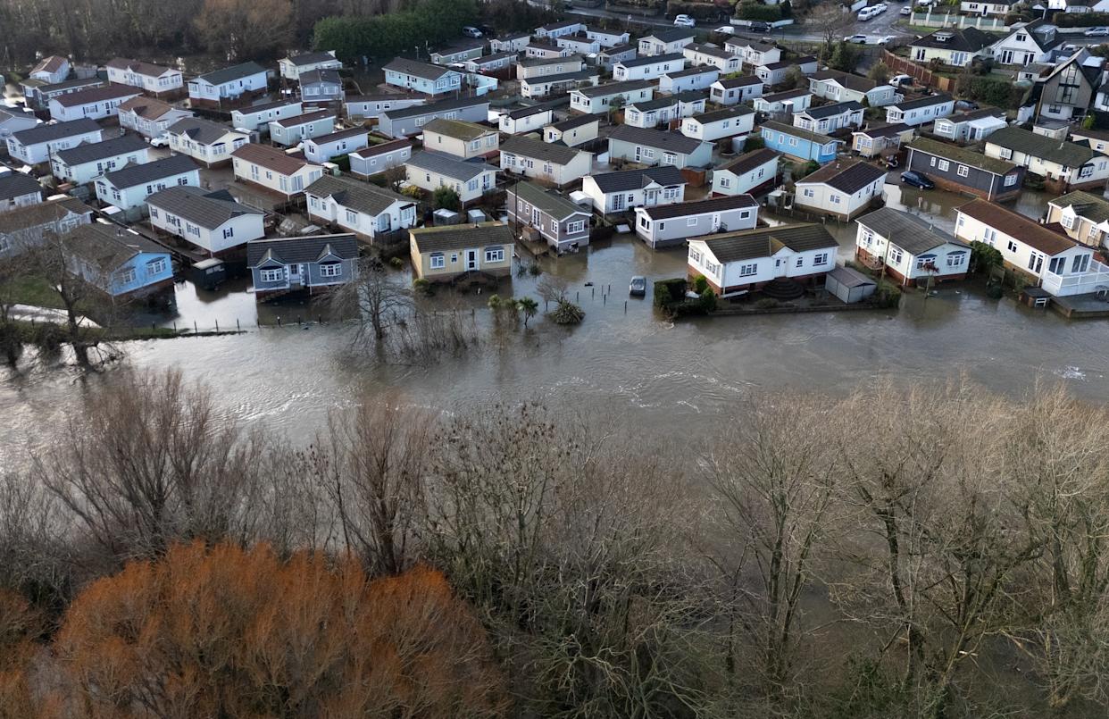
Parts of the UK have already flooded following several storms and heavy rain on saturated ground.
(Anna Barclay via Getty Images)
If you were hoping for an end to the incessant rain, you’re out of luck, with more wet weather expected in the coming days as forecasters warned “there’s no end in sight”.
The Met Office said rain has fallen every day of 2026 in south-west England and South Wales, with the regions experiencing a far wetter than average January, with 50% more rainfall than usual.
Scotland hasn’t had it much better, with Aberdeen having seen no sunshine for two weeks – the longest period for the area since records began in 1957.
The rain in January in the south-west region was the 12th highest on record, and there’s no sign of a reprieve in the coming days as a yellow rain warning remains in place until 9pm on Friday for parts of Wales, south-west and south-east England and the West Midlands, having run from 5am on Thursday.
Another yellow warning is in place for Northern Ireland until midnight on Friday.
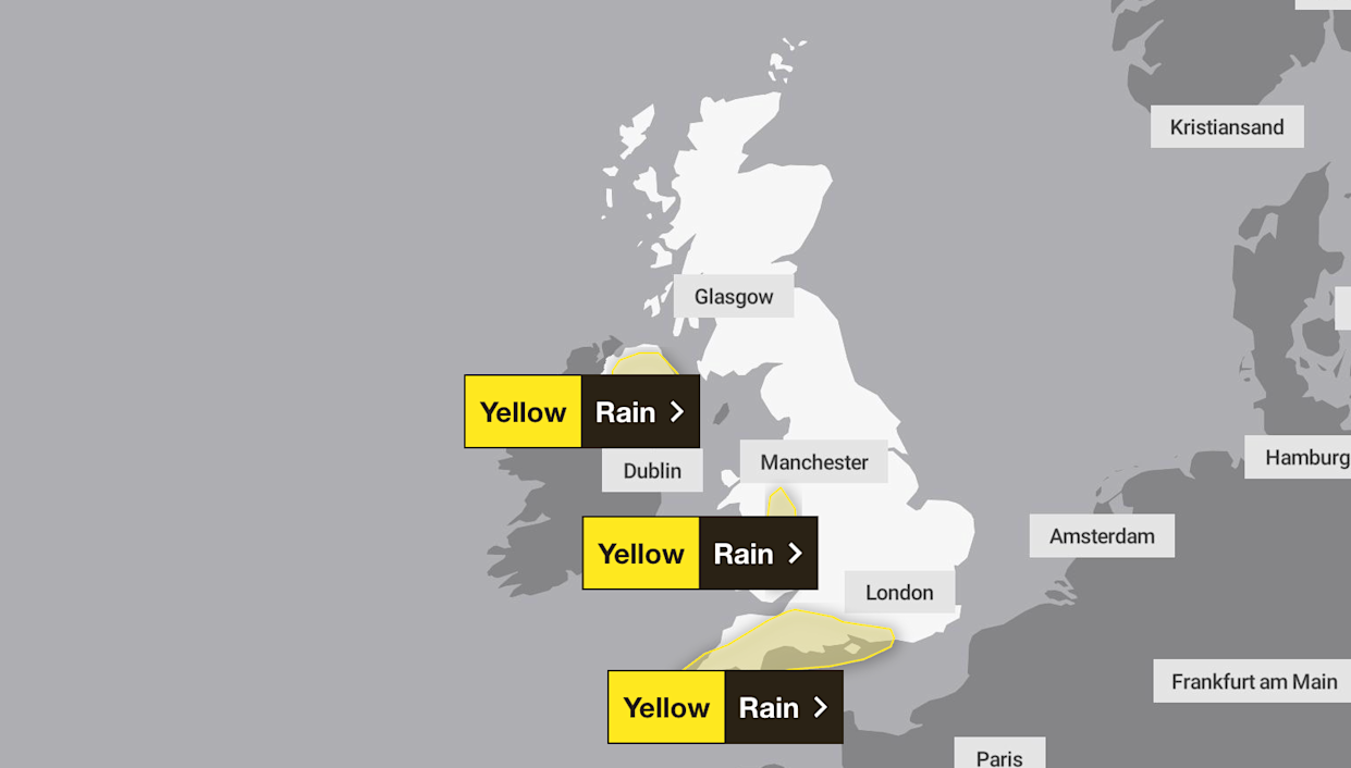
A yellow weather warning for rain is in place for Friday.
(Met Office)
The yellow warning predicts 20-30mm of rain, with some higher ground areas seeing more than 50mm, and the potential for some surface water flooding because of widely saturated ground, along with the risk of flooding to some homes and businesses. Journey times and transport links could be affected, and power supplies could be interrupted briefly.
The warnings are the latest in a spate of other alerts as damp conditions have dogged the start of the year, with Met Office operational meteorologist Dan Stroud saying: “Unfortunately, there’s no end in sight”, forecasting that another band of rain was due to travel northwards on Friday with heavy bursts.
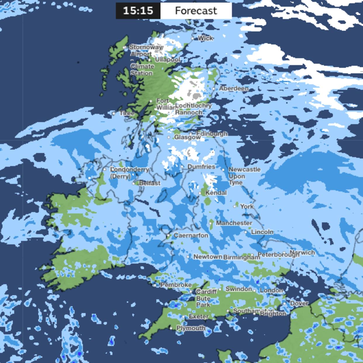
This map shows precipitation over the UK for 3pm on Friday (6 February), where the lighter blue colour indicates the most rain.
(Met Office)What is the Met Office weekend weather forecast for the UK?
Heavy showers will continue in the south on Saturday morning before they gradually push up into Wales and the Midlands, according to Met Office forecasts.
At the same time, persistent cloud and rain will cover eastern Scotland, including Aberdeen.
Some brightness will break through on Saturday for parts of East Anglia, the south-east and possibly west Scotland.
Sunday should be a slightly drier day for those who are not in the southern and western parts of the UK, who will see yet another band of rain arrive.
Stroud said: “Very little in the way of change, and the reason for it really is that we’ve got a big area of high pressure way out to the far north and east of the country and that’s stopping areas of low pressure from moving through.
“Until that area of high pressure sort of shifts out of the way, we’re not really going to see much of a change in the forecast.
“At the same time, we’ve got the jet stream way to the south, bringing exceptional wet weather to Spain and Portugal.”
Why is it so wet at the moment?
More wet weather is on the cards for next week. According to the Met Office forecast for Tuesday (10 February) to the following Thursday (19 February), weather fronts are set to bring more wet weather to the UK.
“Some southern and western areas remain most prone to seeing the wettest conditions, which will maintain sensitivity to further flooding impacts,” the forecast said. “Parts of northeast Britain may also be wetter than normal.”
Many will be wondering why there’s so much rain right now, given the dry weather that dominated last year.
According to a blog from the Met Office, the main reason is the jet stream.
“This powerful ribbon of air, flowing several miles above the earth’s surface, has often been strong and positioned further south than we typically expect at this time of year,” it explained.
“When the jet stream shifts south across the Atlantic, it tends to funnel low-pressure systems directly towards the UK, increasing the frequency and intensity of rain-bearing weather fronts. Some intense wind storms have also occurred, such as Storm Goretti.”
A combination of cold “plunges” across North America, combined with warmer areas “energises” the jet stream, the Met Office explained, while high pressure over parts of northern Europe created a “blocked pattern”, preventing any significant shift in the position of the jet stream and limiting our chances of more settled, drier weather developing.
“This blocking high has also prevented the weather fronts pushing through and clearing the UK. Instead they have been stalling over the UK, leading to persistent slow moving bands of rain.”
The Met Office said when the atmosphere gets stuck in this way, it can take a while to reset, which means unsettled weather is likely to continue.
“However, as we move into the following week, there are tentative signs of a subtle shift,” it added. “High pressure looks more likely to build towards Greenland rather than Scandinavia. This small but important change could help northern parts of the UK turn a little drier for a time.”
The wet weather is caused by the jet stream, the Met Office has explained.
(PA)
Here, Yahoo News UK breaks down, using Met Office forecasts, what the weather will be like for each region of the UK over the next few days:
London and the South East
Mostly cloudy with showers or longer spells of rain, these perhaps heavy at times. Breezy, especially towards the coast. Maximum temperature 11 °C.
Variable cloud and scattered showers Sunday and Monday, with mist and fog during the mornings. Cloud and rain likely return late Monday and continue into Tuesday. Temperatures near average.
South West
An unsettled start as further blustery showers feed in from the south through much of the day. These clearing northeastwards later, allowing some brighter and drier spells. Winds easing. Maximum temperature 11C.
Sunday brings a mix of showers and sunny spells, before turning unsettled from the west again to start the new week, with further bands of heavy rain. Breezy at times.
Midlands
East: Mostly cloudy with showers or longer spells of rain, these perhaps heavy at times. Breezy, especially towards the coast. Temperatures near average for the time of year. Maximum temperature 10C.
West: Turning increasingly cloudy through the morning with a continuation of heavy showers through much of the day, though these becoming lighter later. Breezy at times. Maximum temperature 9C.
East: Variable cloud and scattered showers Sunday and Monday, with mist and fog during the mornings. Cloud and rain likely return late Monday and continue into Tuesday. Temperatures near average.
West: Sunday brings a mix of showers and sunny spells. A murky start to the new week, with light showers through Monday, before widely wet and windy from the west overnight.
Flooding at Iford Bridge Home Park in Bournemouth following heavy rain, with more due across the south west.
(Andrew Matthews – PA Images via Getty Images)North East
Cloudy with further outbreaks of rain throughout. Becoming breezy, especially along the coast. Slightly milder than recent days, but still feeling chilly in the wet conditions. Maximum temperature 8C.
Variable cloud and scattered showers Sunday and Monday, with mist and fog during the mornings. Cloud and rain likely return late Monday and continue into Tuesday. Temperatures near average.
North West
A brighter start, though quickly turning unsettled from the south as a band of heavy showers spreads northwards through the morning, with further outbreaks through the day. Breezy at times. Maximum temperature 9C.
Sunday brings a mix of showers and sunny spells. A cloudy start to the new week, with further light showers, before widely wet and windy conditions continue from the west.
Wales
A rather unsettled day, as a band of heavy showers spread northwards across the region. However, some brighter and drier breaks may be possible in the west though the afternoon. Maximum temperature 10C.
Sunday brings a mix of showers and sunny spells. However, turning unsettled from the west again to start the new week, with further bands of heavy rain. Breezy at times.
Scotland
Mostly cloudy with a few outbreaks of rain but generally becoming drier, some bright or sunny intervals in the west. Cloudy in the afternoon with heavier rain spreading north. Maximum temperature 8C.
Bands of showers or longer spells of rain will pass north during this period. These will be interspersed with dry and occasionally brighter spells at times especially on Monday.
Northern Ireland
Mostly cloudy morning with occasional outbreaks of rain, mainly north and east. Drier in the afternoon with bright or sunny spells before turning cloudy with rain in the east later. Maximum temperature 8C.
Remaining largely cloudy with occasional outbreaks of rain, some brighter spells possible at times. Winds mostly light but breezy near the coast.