
This week is going to start out feeling like a mild stretch of spring, with temperatures hitting the 50s and even angling toward 60 in parts of southern Michigan, while Northern Michigan and the Upper Peninsula get some above-normal temperatures, too.
Than all that is going to change for some of us by late Tuesday or early Wednesday, when a mid-week storm system is expected to roil the state. The early forecast calls for snow and ice to the north and rain to the south.
Here are the statewide forecast highlights from the National Weather Service offices across Michigan:
Michigan residents should prepare for a significant winter weather event Tuesday night through Wednesday, with forecasters warning of heavy snow, mixed precipitation including freezing rain, and strong winds across much of the state.
The National Weather Service has issued Gale Watches for portions of Lake Superior beginning Tuesday afternoon, with confidence growing that an impactful winter storm will move into the Great Lakes region. The system is expected to bring a complex mix of precipitation types, with the potential for travel disruptions and hazardous conditions.
**Timing and Expected Conditions**
The winter storm is forecast to arrive Tuesday night and persist through at least Wednesday. The Upper Peninsula appears positioned for the heaviest snowfall, with accumulations potentially exceeding six inches across the eastern U.P.
Northern Lower Michigan faces a more complicated forecast, with a “virtual potpourri of precipitation types” expected. The northern reaches could see a mix of snow, sleet and freezing rain, while southern areas of the state are more likely to experience primarily rain, though some freezing rain remains possible. Meteorologists express growing concern that east-northeast low-level winds may prevent surface warming, potentially resulting in an extended period of ice accumulation in areas where freezing rain becomes the dominant precipitation type.
Strong easterly winds will accompany the system, with gusts potentially reaching 35 knots on northern Lake Huron from Wednesday morning through early afternoon. The combination of wet, heavy precipitation and gusty winds could create additional hazards, including power outages and dangerous travel conditions.
**Near-Term Conditions**
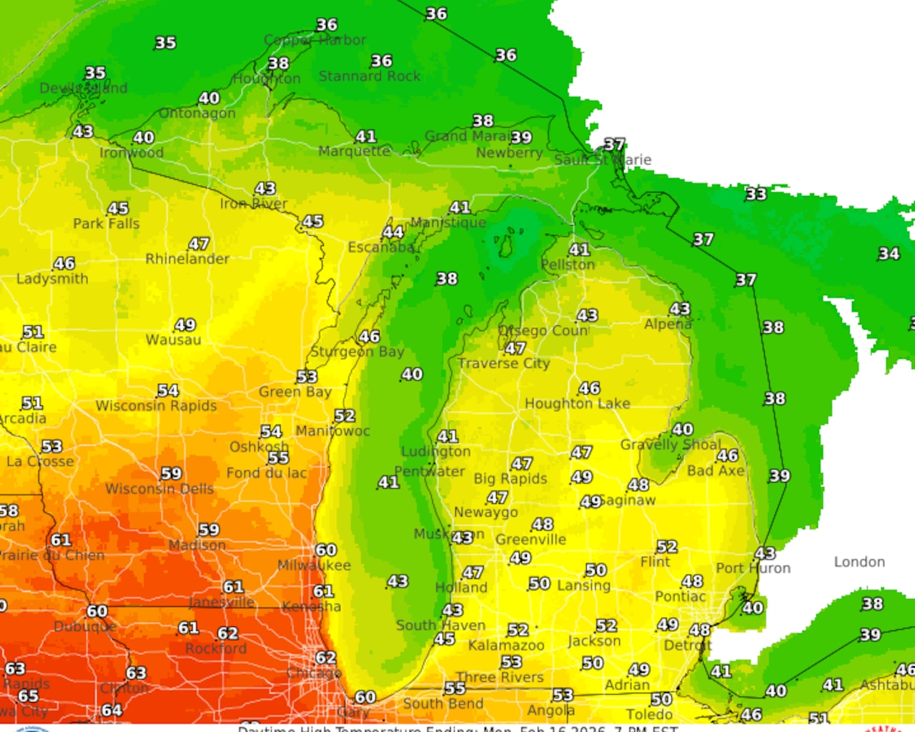
Before the midweek storm arrives, Michigan residents can expect mild, above-normal temperatures to continue. Monday will bring highs in the 40s across much of the northern Lower Peninsula, with mid-30s to near 40 degrees north of the Mackinac Bridge. Some locations near Saginaw Bay and along the M-72 corridor could reach the low 50s. Patchy fog and stratus development is likely again tonight across parts of the state, with visibilities falling to one-quarter mile or less in spots, particularly at locations like Houghton County Memorial Airport and Pellston Regional Airport.
A weak weather system Monday may bring brief light snow showers to the eastern Upper Peninsula late tonight into early Monday morning, with a slight possibility of freezing rain. These chances will spread across the remainder of the eastern Upper Peninsula and into the tip of the mitt mid-morning through early afternoon before diminishing. Minor snow accumulation or patchy ice is possible, though significant impacts are not anticipated.
**Extended Outlook**
The active weather pattern may persist beyond the midweek storm. A secondary low-pressure system could bring additional precipitation Thursday evening into Friday, though there is considerable uncertainty regarding the track, timing and strength of this system. Current guidance suggests less overall precipitation than the Wednesday system, with a more wintry airmass in place that would favor snow over mixed precipitation.
Looking further ahead, the pattern shift late this week into next weekend could bring temperatures back toward seasonal norms, with another chance for snow over the weekend. Multiple forecast offices note the potential for additional southern stream waves to track across the Great Lakes late in the week and possibly again over the weekend, maintaining the threat for wintry impacts.
The mild temperatures early this week, combined with rainfall and snowmelt from the midweek system, may lead to rises on area rivers and ponding in low-lying areas. However, with snow water equivalent values currently ranging between 0.5 and one inch across most areas, significant flooding is not expected at this time.