
After a messy mix of rain and snow on Friday, the region needs to get ready for what’s beginning to look like an impactful nor’easter beginning Sunday night and lasting through Monday.
Confidence is increasing that a coastal storm will develop off the Carolinas, then ramp up quickly as it passes south and east of New England Sunday night into Monday.
You’ll hear the term bombogenesis with this one. That’s simply rapid strengthening — defined as a big pressure drop — 24 millibars or more within 24 hours. The expectation right now is for that intensification to happen southeast of Nantucket on Monday, which is a classic way to boost wind, increase ocean-driven moisture, and tighten up the “gradient” between heavy snow and very little at all.
A few weeks back, we tracked a potential nor’easter that ultimately slid out to sea. So, what’s different this time? Two big things:
The jet stream is closer to New England. Somewhat counterintuitively, that can happen when there’s less entrenched Arctic air locking the pattern up, allowing the storm track to shift a bit closer to the coast. The upper-level ingredients are interacting in a more classic way. With multiple pieces of energy phasing more efficiently, the storm has a better pathway to strengthen and “feel” the coastline, rather than racing harmlessly away offshore.
That doesn’t eliminate uncertainty, it just raises the odds that this one matters for more of us.
Here’s what we know so far:
Before the main event: A little leftover snow on Saturday
Saturday is mostly a cleanup day from the snowy mix Friday evening. Any lingering snow is light and fades out mid- to late-morning, with temperatures hovering in the low- to mid-30s.
One small wrinkle: Snow showers may pop up Saturday evening leaving an additional coating here or there.
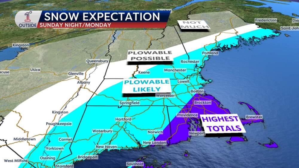
Sunday into Monday snow potential
The most honest way to talk about snowfall right now is probabilities, rather than a single accumulation map with numbers.
 (Danielle Noyes/1DegreeOutside)
Here’s where the signal is strongest:
Heavy snow for the South Shore to Cape Cod — a foot or more is possible Plowable snow for the remainder of southern New England Some of the “worst case” scenarios show over 2 feet of snow from Worcester to BostonThe other half of the story: wind
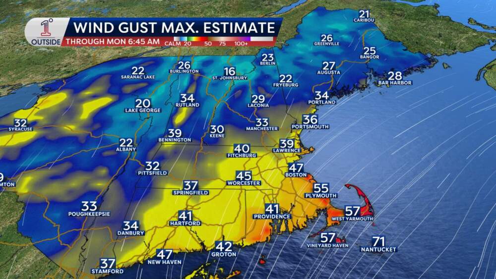
If the storm strengthens as expected Monday (again, likely rapidly southeast of Nantucket), wind will have a significant impact.
It’s likely wind gusts inland could reach about 30 to 40 mph, and on the coast 40 to 50 mph. The highest potential for stronger gusts is from the South Shore to Cape Cod, where 55 to 65 mph can’t be ruled out (with isolated higher gusts for places like Chatham to Nantucket).
The combination of heavy snow bands and strong wind will means blizzard-like conditions Monday pre-dawn through early afternoon at times with near-zero visibility, blowing and drifting snow, and treacherous travel.
 (Danielle Noyes/1DegreeOutside)Coastal concerns
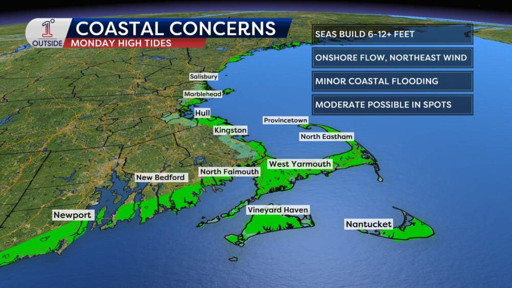
Mariners and coastal communities should pay close attention to this storm. Seas ramp up Sunday afternoon and evening, then build substantially Sunday night into Monday.
Offshore seas: 10-16 feet, potentially peaking 20-25 feet Monday afternoon and evening Nearshore/coastline: 8-12 feet possible through Monday afternoon and evening
Onshore flow plus peak wave action will produce widespread minor pockets of coastal flooding during Monday’s high tide cycles (possibly lingering into Tuesday morning). The highest risk of moderate flooding is from the South Shore to Cape Cod Bay and Nantucket.
 (Danielle Noyes/1DegreeOutside)
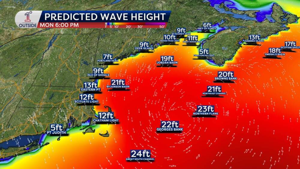 (Danielle Noyes/1DegreeOutside)Bottom line: increasing confidence, but expect tweaks
The overall signal is getting stronger, and now is the time to start thinking about preparation — but there will still be wobbles and shifts in the forecast over the next couple of days. It’s normal to see changes in accumulation maps, timing and impact windows as the storm comes into sharper focus.
For the latest forecast updates as things tighten up, check 1DegreeOutside.com or the free 1DegreeOutside mobile app.