
After a headache of a forecast, things are starting to slow down Monday morning.
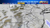
Nor’easter track: Our coastal storm will slowly pull away throughout the morning and afternoon hours. That widespread accumulating snow will now be taking aim for New England.
The coast and much of New Jersey look to see the highest numbers: As the forecast suggested New Jersey and the coastline saw and will continue to see the brunt of this storm throughout the morning. Whiteout conditions, heavy snow, and 50+mph gusts can still be seen for these areas into later morning and early afternoon.
Timing: Most of the region has already started wrapping up the bulk of the accumulating snow from this storm early Monday morning. Some flakes can still follow us into early afternoon before we quiet out completely by later afternoon.

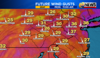
Winds: Winds will be strongest at the shore, where 50-55mph gusts are expected. Farther inland, winds still have the potential to gust at 30-40mph into the afternoon.
Warnings: Winter storm warnings are still in effect for much of eastern Pennsylvania. These are slated to expire at 6 p.m. Monday night. For all of New Jersey and most of the Delaware Valley along with Monroe and Carbon counties, blizzard warnings are in effect. These are also slated to expire at 6 p.m. Monday night. These will most likely be cut back as we get into the afternoon especially for the Pennsylvania counties as snow will be moving out of these locations first.

TOTALS:
There has been a wide range of snow totals across the area and snow is still falling for some. We will keep you updated with those final totals as they roll in throughout the afternoon and evening.
Our meteorologists have an update on snow totals, as of about 9 a.m. Monday
TRACK THE WEATHER:
LINKS: HOUR BY HOUR | RADAR | TRAFFIC