
Monday Evening March 2 2026
Thank you for reading this post, don’t forget to subscribe!
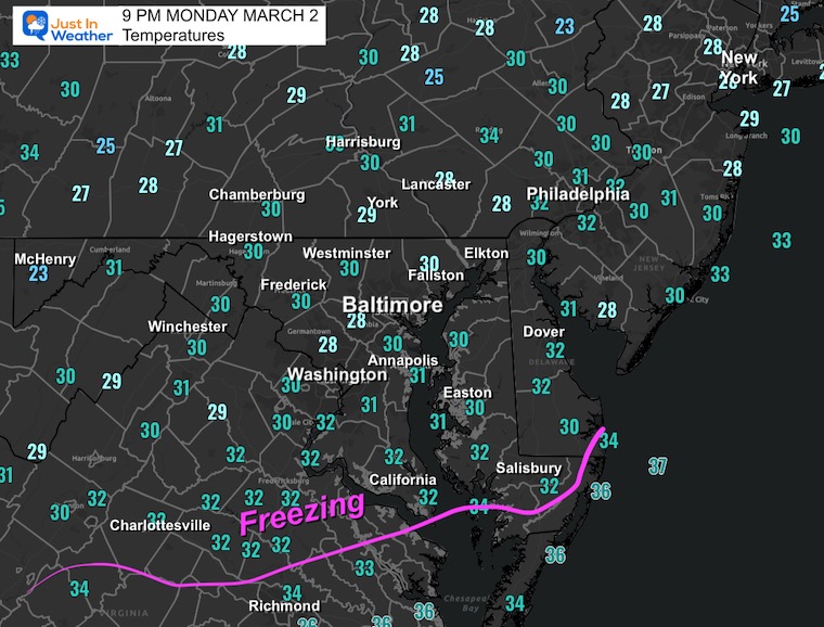
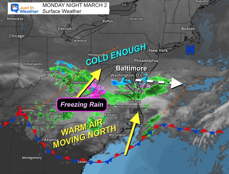
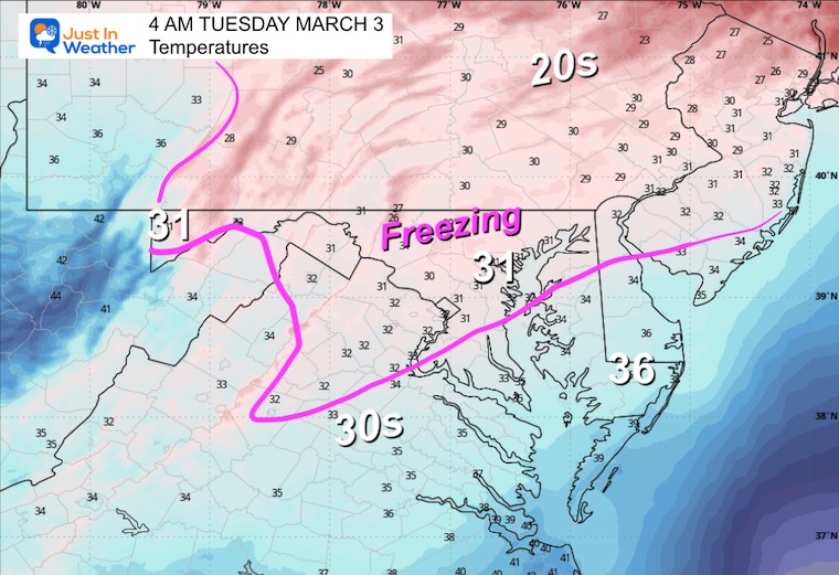
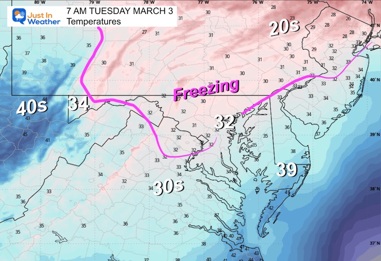
The second part of this winter weather system will arrive overnight into Tuesday morning with a period of Freezing Rain. The irony is that the first part during Monday brought snow that melted on the pavement. Now we expect the colder air to hang right along the ground as warm air flows at cloud level. My concern is that air temperatures dropped lower than expected with the Monday afternoon snow and have held colder tonight.
Ground temperatures will be the focus as we head into the early morning.
In this report a look at the Live Radar Widget and Simulation Forecast.
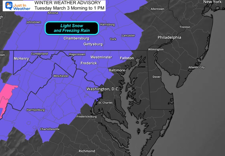
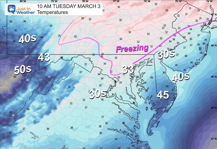
Winter Weather Advisory
The Winter Weather Advisory is for counties West and North of Washington and Baltimore where there may be lingering impacts for the morning commute. Yes, that could mean schools as well. But that will be a game time decision.
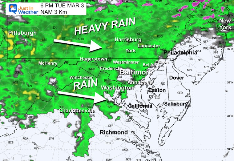
Whiplash was the best way I could describe the weather in my morning report, and it lived up to the hype, even exceeded it. After the 60s and even some spots near 70F on Saturday, Monday brought us a slushy, wet snow. This developed midday and into the afternoon with a burst of moderate to heavy snow in a narrow band near I-66 in Northern Virginia and across Washington DC and Baltimore.
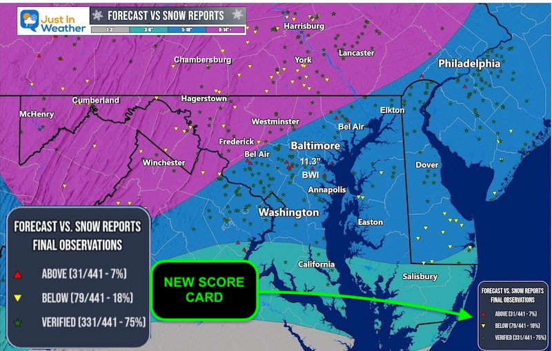
The daytime helped as the roads stayed wet, but preliminary reports had pockets of 1 to 3 inches of snow. Even North Baltimore City got 1.5”. BWI has not reported yet, so I am waiting to see the official number there to add to our seasonal tally.
Preliminary Snow Reports
Worst Conditions In The Mountains
Set Up
Monday Night Temperatures
Monday Night Surface Weather
Forecast: Wide View
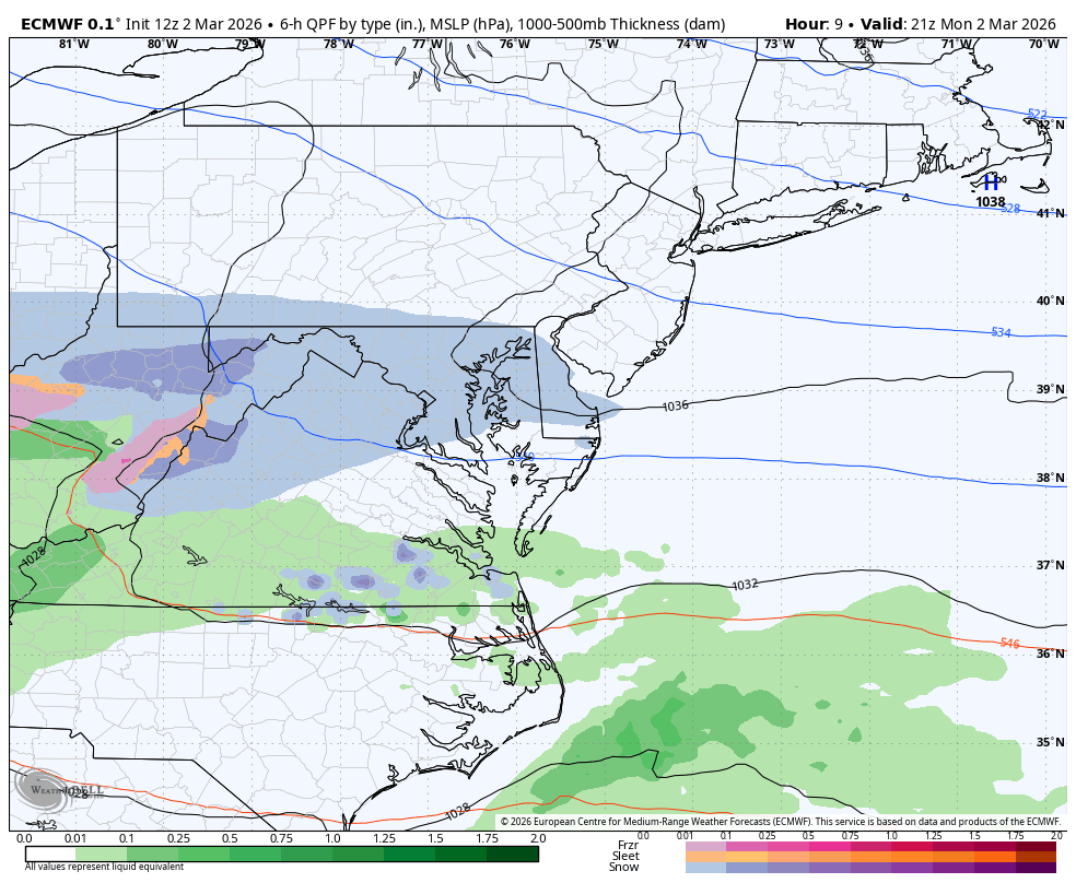
The first wave was a push of snow to the East. The second wave overnight is the push of warmer air to the North. This is what will produce a pocket of freezing rain as the cold air is hugging the ground while warmer air flows first at cloud level.
LIVE RADAR WIDGET
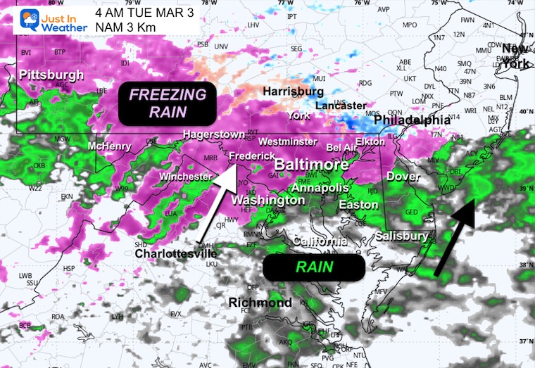
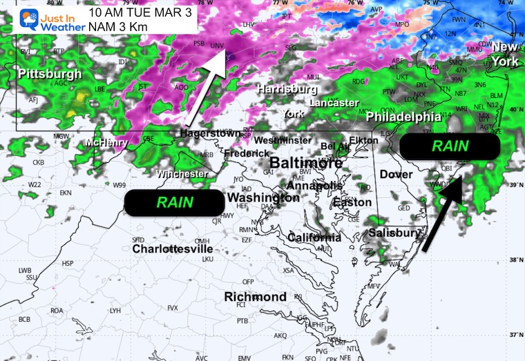
Radar Simulation Tuesday
Midnight to 7 PM
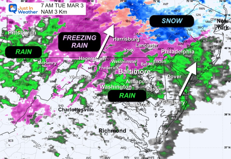
This is a SUGGESTION, Not A Promise. It also does not account for the colder setup tonight, so the freezing rain may affect more areas from 4 AM to 7 AM.

SNAPSHOTS
REMINDER: This is a SUGGESTION, Not A Promise. It also does not account for the colder setup tonight, so the freezing rain may affect more areas from 4 AM to 7 AM.
Early Morning at 4 AM
Temperatures
Radar Simulation
Daybreak at 7 AM
Temperatures
Radar Simulation
Late Morning at 10 AM
Temperatures
Radar Simulation
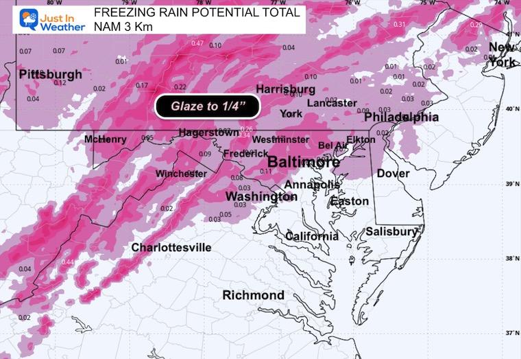
Ice Forecast
This will not be a heavy ice event. A glaze up to 1/4 inch inland, where it lasts longer. This is just enough for a coating on untreated areas. Most susceptible will be elevated surfaces from steps to overpasses.
Evening At 6 PM
Plain old rain will return at night, and it may be heavy at times.
Temperatures
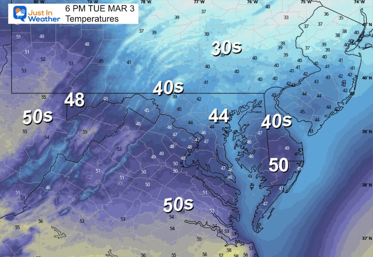
Radar Simulation
That’s it for now. I will be up early with a focus on the temperatures for icing and to see if the ground responds or holds on to some heat.
Subscribe for email Alerts
Weather posts straight to your inbox
Sign up and be the first to know!
FAITH IN THE FLAKES STORE
NOW OPEN FOR THE SEASON

January 25 Snow Report AND Grade My Forecast
Click here to see the full report
Snow Report December 14 and Grade My Forecast
In case you missed it, click this image for brief summary of the final snow totals from the last event.
Snow Report December 5 to 6 and Grade My Forecast
In case you missed it, click this image for brief summary of the final snow totals from the last event.

My Winter Outlook For Above-Average Snow
Click here for the full report
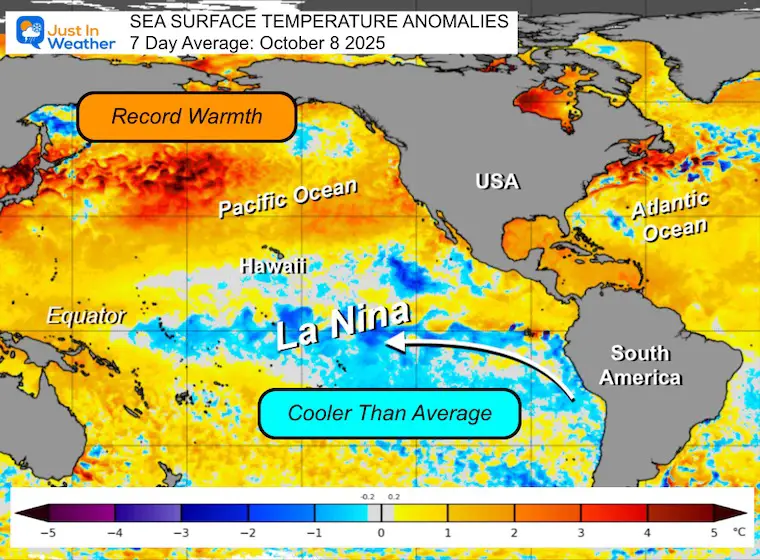
La Niña Advisory
This was issued October 9, as expected: A weak and short-lived event to start winter may play a different role this winter.
In Case You Missed It
Woolly Bear Caterpillar Winter Folklore
These are NOT all the same caterpillar!

Winter Outlook From 2 Farmers’ Almanacs

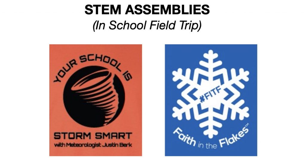
STEM Assemblies/In School Fields Trips Are Back
Click to see more and ‘Book’ a visit to your school
THANK YOU:
Baltimore Sun Magazine Readers’ Choice Best Of Baltimore

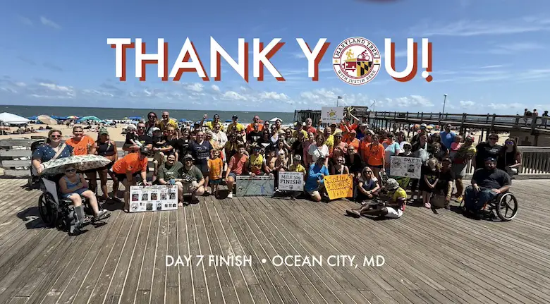
Maryland Trek 12 Day 7 Completed Sat August 9
UPDATED: We raised OVER $170,000 for Just In Power Kids – AND Still Collecting More
The annual event: Hiking and biking 329 miles in 7 days between The Summit of Wisp to Ocean City.
Each day, we honor a kid and their family’s cancer journey.
Fundraising is for Just In Power Kids: Funding Free Holistic Programs. I never have and never will take a penny. It is all for our nonprofit to operate.
Click here or the image to donate:
RESTATING MY MESSAGE ABOUT DYSLEXIA
I am aware there are some spelling and grammar typos and occasional other glitches. I take responsibility for my mistakes and even the computer glitches I may miss. I have made a few public statements over the years, but if you are new here, you may have missed it: I have dyslexia and found out during my second year at Cornell University. It didn’t stop me from getting my meteorology degree and being the first to get the AMS CBM in the Baltimore/Washington region. One of my professors told me that I had made it that far without knowing and to not let it be a crutch going forward. That was Mark Wysocki, and he was absolutely correct! I do miss my mistakes in my own proofreading. The autocorrect spell check on my computer sometimes does an injustice to make it worse. I can also make mistakes in forecasting. No one is perfect at predicting the future. All of the maps and information are accurate. The ‘wordy’ stuff can get sticky. There has been no editor who can check my work while writing and to have it ready to send out in a newsworthy timeline. Barbara Werner is a member of the web team that helps me maintain this site. She has taken it upon herself to edit typos when she is available. That could be AFTER you read this. I accept this and perhaps proves what you read is really from me… It’s part of my charm. #FITF
Please share your thoughts and best weather pics/videos, or just keep in touch via social media.