
The active weather pattern in the Boston area continues. On the heels of Tuesday night’s wintry mix, we are issuing yet another NEXT Weather Alert for a wintry “mess” headed our way Thursday night and early Friday.
The impacts will vary across Massachusetts. In Worcester County, the main impact will be ice accretion. In Essex County, they will likely be plowing snow. Across southeastern Mass., heavy rainfall will lead to localized flooding.
And, in between those areas, a little of everything.
When will the rain and snow start?
Daytime Thursday: Some scattered rain/sleet showers, very low impact. Overall a gloomy, cool and damp day.
After dark Thursday: Steadier precipitation moves in. Temperatures start to tick down, changing the rain to sleet and freezing rain in most areas along and north of the Mass Pike.
Throughout the overnight, we will continue to see periods of heavy rain across southeastern Massachusetts and a mix of sleet and freezing rain north and west of I-95.
Ice concerns
Untreated roadways will quickly become slick and treacherous in the freezing rain zone.
Our greatest concern for ice accretion is in Worcester County and in western Mass./Connecticut, where up to .25″ or more will accrete on power lines, trees and any untreated surfaces around your home.

WBZ-TV graphic
CBS Boston
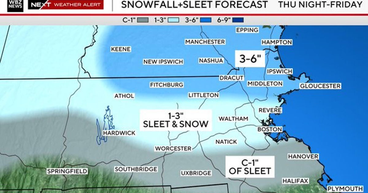
How much snow from the storm?
Toward the tail end of this event, early Friday morning, the ice will change to snow along and north of the Massachusetts/New Hampshire border and also across northeast Massachusetts.
This is our best chance to accumulate snowfall, between about 5 a.m. to 9 a.m. Friday morning.
There may be as much as 3-6″ of snow across a highly localized region including Essex County and southeastern New Hampshire.
In northern Worcester County, northern Middlesex County and in the Boston Metro area, there will be 1-3″ of sloppy sleet and wet snow.
Southern Worcester County and Norfolk county, a coating to an inch of sleet.

WBZ-TV weather graphic
CBS Boston
The precipitation will gradually come to an end mid-morning on Friday.
We expect the greatest impacts and most treacherous travel to occur between 9 p.m. Thursday and 9 a.m. Friday.
Conditions will slowly improve throughout the day on Friday.

WBZ-TV graphic
CBS Boston
Potential flooding
We are concerned for pockets of localized flooding across southeastern Mass., where most of the precipitation will fall as rain. We expect between 1-1.5 inches of rain to fall over this area which, of course, still has a very extensive snowpack.
If you are able, it would be prudent to make sure your gutters and nearby storm drains are clear. Also try and carve out some “channels” for water to flow safely away from your house.
Warmer weather coming to Boston
Once we get past this event, the weather story will shift more toward warmth and melting. Temperatures will rise into the 50s in parts of our area this weekend.
Next week looks quite mild – we’ve got a shot at 70 degrees by midweek. With temperatures like that and a much higher sun angle, just about all of the snow cover should be gone by this time next week.
More from CBS News