
Iowa weather: What to know about the potential winter storm this weekend
START THEIR SPRING BREAK. NOW. MARCH. IOWA. WE KNEW. WE KNEW WE WEREN’T DONE WITH THE SNOW. BUT THIS BASKETBALL TO WATCH. THERE YOU GO. YEAH, YEAH YEAH. THIS WEEKEND THERE’S THE CONFERENCE STILL WRAPPING UP. AND THEN LATER NEXT WEEK WE’LL HAVE THE WARM STUFF HERE FOR THE ACTUAL NCAA ACTION. NOW LET’S TALK ABOUT THIS WEEKEND HERE. FIRST UP. SO THE WINTER STORM WATCH THAT STARTS UP FOR MOST FOLKS AT DIFFERENT TIMES ON SUNDAY MORNING DEPENDING WHERE YOU’RE AT. BUT IT LASTS UNTIL MONDAY MORNING. MORE THAN HALF OF IOWA HERE IS COLORED IN THE BLUISH COLOR. WHAT WILL PROBABLY HAPPEN IS WE GET A LITTLE BIT CLOSER TO THE ACTUAL WEATHER SYSTEM COMING THROUGH, IS THAT A LOT OF THIS WILL BE CONVERTED OVER TO EITHER A WINTER STORM WARNING, LIKE IT ALREADY HAS BEEN UP IN MINNESOTA, OR BLIZZARD WARNING, BECAUSE WE’RE GOING TO HAVE, REGARDLESS OF HOW MUCH SNOW FALLS, 50 TO 60 MILE PER HOUR WINDS, WHICH WILL BLOW AROUND WHATEVER AMOUNT OF SNOW THERE IS. AND THAT’S GOING TO CAUSE PROBABLY SOME WHITEOUT CONDITIONS. AND THEN WE’LL SEE IF WE GET A WINTER WEATHER ADVISORY DOWN FOR PARTS OF SOUTHERN IOWA. THAT’S JUST GOING TO DEPEND A LITTLE BIT ON HOW MUCH SNOW REALLY COMES THAT FAR SOUTH, WHICH THAT PART STILL REMAINS A LITTLE BIT TO BE SEEN. SO HERE’S THE GENERAL OUTLINE, IF I CAN SIMPLIFY IT AS MUCH AS POSSIBLE FOR YOU, THIS IS WHAT WE’LL LOOK AT ON SUNDAY MORNING. FOR MOST OF US. WE’LL START WITH A LITTLE BIT OF SOME LIGHT RAIN, ACTUALLY, MAYBE EVEN A RUMBLE OF THUNDER. TEMPERATURES BRIEFLY GO UP INTO THE 50S AND THEN THEY FALL BASICALLY THE REST OF THE DAY AND INTO THE NIGHT BY THE AFTERNOON HOURS. FOR A LOT OF US, THAT’S WHEN THE SWITCHOVER FROM THAT RAIN OVER TO SNOW ACTUALLY BEGINS. THAT’S WHEN WINDS WILL NOW START TO RAMP UP TO GUSTING 50 PLUS MILES PER HOUR. THAT CONTINUES ALL THE WAY INTO TONIGHT, THE WIND GUSTS. SO THAT’S WHY WE COULD HAVE POSSIBLE BLIZZARD CONDITIONS WHITEOUTS, WHATEVER YOU WANT TO CALL IT. AND OUR TEMPERATURES WILL CONTINUE TO FALL SO MUCH. SO THE COMBINATION OF THE COLD AND THE WIND. BY THE TIME WE HIT LATE SUNDAY NIGHT, MONDAY MORNING, WIND CHILLS, WIDESPREAD SUBZERO TEENS BELOW ZERO, EVEN SOME WIND CHILLS AS COLD AS -20. WE’LL SHOW YOU HERE IN A SECOND. NOW GENERAL LOOK AT SNOWFALL. OBVIOUSLY THIS IS OUR FIRST FORECAST. OKAY. WE’RE GOING TO HAVE ABOUT THREE MORE CYCLES OF DATA BEFORE ANY SNOW ACTUALLY FALLS. FOR MOST OF US. TO ACTUALLY FINE TUNE THIS, WE’LL TIGHTEN DOWN THE RANGES GEOGRAPHICALLY AND THE ACTUAL AMOUNTS, BUT STILL LOOKS MOST LIKELY THE HEAVY HEAVY STUFF. DOUBLE DIGIT AMOUNTS PROBABLY GOING TO BE IOWA, MINNESOTA BORDER AND NORTHWARD. AND THEN WE’LL SEE AMOUNTS DROP OFF HERE INTO CENTRAL IOWA, SOUTHWEST IOWA. PROBABLY THE LEAST AMOUNTS. THERE WILL BE SOME. YOU SEE THIS LITTLE BIGGER AREA OF, YOU KNOW, SEVERAL INCHES POSSIBLE IN EASTERN IOWA. THAT’S BECAUSE THE SYSTEM WRAPS UP AND MOVES OFF TO THE EAST. THERE WILL BE SOME LINGERING OVERNIGHT SNOW INTO EARLY MONDAY, AND THAT’S THE MOST LIKELY ZONE OUTSIDE. RIGHT NOW. WE JUST HAVE SOME CLOUDS STREAMING OVERHEAD. THAT SYSTEM THAT BROUGHT US ALL THE WIND, IT’S OFF TO OUR EAST NOW. HIGH PRESSURE NEARBY, AND THEN A LITTLE BIT OF MOISTURE KIND OF STREAMING IN BETWEEN. BUT THAT’S ALOFT. IT’S NOT NECESSARILY REACHING THE GROUND. THAT IS WHERE WE WILL GET AT LEAST A FEW SNOWFLAKES THOUGH, TO FALL, ESPECIALLY ACROSS NORTHERN IOWA LATE TONIGHT AND INTO TOMORROW MORNING. MINIMAL ACCUMULATION THOUGH, MINIMAL IMPACT. NOW AS WE GO THROUGH THE DAY TOMORROW AND YOUR SATURDAY. THICKEST CLOUDS STAY ACROSS NORTHERN IOWA. A LITTLE BIT THINNER CLOUD COVER, EVEN SOME SUN TO THE SOUTH. BRISK SOUTHEAST BREEZE, BUT NOT THE WINDS THAT WE’RE GOING TO SEE AFTER TOMORROW. HERE’S YOUR TEMPERATURES FOR SATURDAY. NOT BAD. 40S ACROSS THE NORTHERN PART OF THE STATE. FAIRLY TYPICAL 50S HERE AROUND THE DES MOINES AMES AREAS, MAYBE NEAR 60. AS YOU HEAD FARTHER OFF TO THE SOUTH AND SOUTHWEST, ESPECIALLY IF YOU GET A LITTLE BIT MORE CLEARING. NOW AS WE HEAD INTO SATURDAY NIGHT, HERE’S WHEN THINGS START TO CHANGE. A LOW PRESSURE CENTER APPROACHES US FROM THE WEST. THIS SHIFTS OUR WINDS INITIALLY TO THE SOUTH, AND THEN THAT’S WHERE WE’LL SEE A FEW OF THESE RAINDROPS EARLY SUNDAY MORNING. NOTICE IN FAR NORTHERN IOWA, ALONG THE MINNESOTA BORDER, A LITTLE BIT A PERIOD OF MAYBE SOME MIXED PRECIPITATION OR EVEN A BRIEF ICING. AND THEN THE SNOW STARTS TO CHANGE OVER FROM NORTHWEST TO SOUTHEAST AS WE GO THROUGH THE DAY. HERE’S NOONTIME. NORTHWEST IOWA NOW HAS MADE THE CHANGE THROUGH THE AFTERNOON. THAT RAIN SNOW LINE CONTINUES SOUTHEASTWARD. MOST OF THE STATE NOW SEEING SNOW. LOOK AT THESE WIND GUSTS AS WELL 45, 50, 55MPH. TURNING TO THE NORTH AND THE WEST. AND AS WE HEAD INTO THE EVENING HOURS, THE SNOW CONTINUES IN VARIOUS BANDS AND SNOW SHOWERS, AND IT STEADILY GETS MORE POWDERY DRY AIR, EASY TO BLOW AROUND. AND THEN REMEMBER HOW WE HAD THAT BIGGER AREA OF SOME SNOW ACCUMULATION ACROSS EASTERN IOWA ON THE MAP EARLIER? THIS IS WHY LATE MONDAY SUNDAY NIGHT INTO MONDAY MORNING, THE SNOW WILL LINGER THE LONGEST IN THAT PART OF THE STATE BEFORE SKIES CLEAR OUT INTO THE DAY ON MONDAY. LOOK AT. STILL, THIS IS MONDAY MORNING WHEN OUR ACTUAL WIND GUSTS STILL 40MPH, SO STILL SOME BLOWING SNOW ISSUES EVEN AFTER THE SNOW IS DONE AND WIND CHILLS. NEGATIVE TEENS TO POSSIBLY AS COLD AS -20 WHEN YOU WAKE UP ON MONDAY. MONDAY AFTERNOON PROBABLY WIND CHILLS SINGLE DIGITS. THAT’S THE HIGH RIGHT AROUND 20 OR 2130. THEN BY SAINT PATTY’S DAY. AND THEN LET’S LOOK AT THE BACK HALF OF THE DAY. MUCH BETTER 50S AND THEN SOME 60S AND PROBABLY EVEN SOME CHANCES, SOM
Iowa weather: What to know about the potential winter storm this weekend

Updated: 7:21 PM CDT Mar 13, 2026
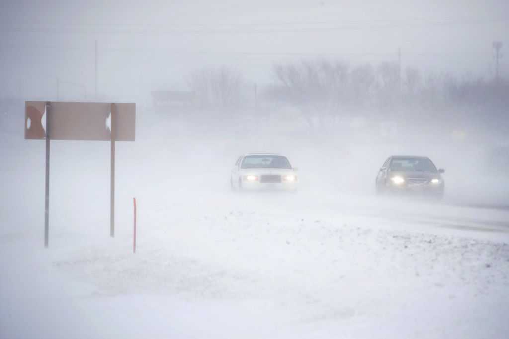
A powerful winter storm is expected to impact the Midwest this weekend bringing more high winds and the potential for snow, and blowing snow creating significant travel disruptions, especially for northern Iowa, Minnesota and Wisconsin.A winter storm watch is in effect Sunday morning through Monday morning. This is when the high winds could combine with snow to produce whiteout conditions.Here’s what you need to know:Winter storm watchMost of the northern half of the state will be in a winter storm watch Sunday morning into Monday morning. This area is most likely to get a glaze of ice, some mixed precipitation, then accumulating snow and wind gusts of 50-60 mph.It’s likely parts of this watch get converted to a winter storm warning or blizzard warning before this system arrives Sunday.Winter storm moves in SundayA strong Colorado Low will move into Iowa Sunday, bringing some rain showers and even a storm or two to central Iowa during the morning. Snow and mixed precipitation will be underway along the Minnesota border. During the afternoon, rain will change to snow from northwest to southeast across Iowa.This is also when wind gusts will ramp up toward 50 mph or higher.The snow will wind down after midnight and leave eastern Iowa by sunrise Monday, but the gusts will continue. That makes whiteout conditions very possible overnight.Expected snowfall accumulationsParts of Minnesota and Wisconsin have the potential for over a foot of snow with 20 or more inches possible in some areas. For northern Iowa, several inches of snow is likely, with some potential for over 6 inches. This is the area that will see the worst conditions.Amounts will be lower in central and southwest Iowa, but there will still be enough snow to cause treacherous travel when combined with the strong winds. Driving will still be tough Monday morning as snow continues to blow in 40-50 mph winds. Frigid wind chills follow For much of central Iowa, Sunday will start in the 50s, then chill down into the 20s by evening. Due to strong gusts, wind chills should drop below 0° late Sunday evening.By Monday morning, much of the state will wake up feeling like -10° to -20°. Even as skies clear Monday, wind chills will only rise into the single digits above zero.
DES MOINES, Iowa —
A powerful winter storm is expected to impact the Midwest this weekend bringing more high winds and the potential for snow, and blowing snow creating significant travel disruptions, especially for northern Iowa, Minnesota and Wisconsin.
A winter storm watch is in effect Sunday morning through Monday morning. This is when the high winds could combine with snow to produce whiteout conditions.

Hearst Owned
Sunday is a Weather Alert day for high winds and snow
Here’s what you need to know:
Winter storm watch
Most of the northern half of the state will be in a winter storm watch Sunday morning into Monday morning.
This area is most likely to get a glaze of ice, some mixed precipitation, then accumulating snow and wind gusts of 50-60 mph.

Hearst Owned
Winter Storm Watch Sunday afternoon through Monday morning.
It’s likely parts of this watch get converted to a winter storm warning or blizzard warning before this system arrives Sunday.
Winter storm moves in Sunday
A strong Colorado Low will move into Iowa Sunday, bringing some rain showers and even a storm or two to central Iowa during the morning. Snow and mixed precipitation will be underway along the Minnesota border.

Hearst Owned
A strong system will bring 50+mph winds and rain to snow and ice back over the state Sunday into Monday morning.
During the afternoon, rain will change to snow from northwest to southeast across Iowa.
This is also when wind gusts will ramp up toward 50 mph or higher.

Hearst Owned
Strong winds return generating gusts 50mph or greater causing substantial blowing snow.
The snow will wind down after midnight and leave eastern Iowa by sunrise Monday, but the gusts will continue. That makes whiteout conditions very possible overnight.
Expected snowfall accumulations
Parts of Minnesota and Wisconsin have the potential for over a foot of snow with 20 or more inches possible in some areas. For northern Iowa, several inches of snow is likely, with some potential for over 6 inches. This is the area that will see the worst conditions.

Amounts will be lower in central and southwest Iowa, but there will still be enough snow to cause treacherous travel when combined with the strong winds.
Driving will still be tough Monday morning as snow continues to blow in 40-50 mph winds.
Frigid wind chills follow
For much of central Iowa, Sunday will start in the 50s, then chill down into the 20s by evening.
Due to strong gusts, wind chills should drop below 0° late Sunday evening.

By Monday morning, much of the state will wake up feeling like -10° to -20°.
Even as skies clear Monday, wind chills will only rise into the single digits above zero.