
WELL, SO FAR THE WEATHER’S BEEN PRETTY QUIET THIS WEEKEND. BUT AS WE MENTIONED AT THE TOP OF THE SHOW, WE DO HAVE A FEW LIGHT RAIN SHOWERS OUT THERE THIS EVENING, AND THAT’S GOING TO CONTINUE OFF AND ON FOR THE REST OF TONIGHT. AND NO SEVERE WEATHER EXPECTED TONIGHT. BUT THERE’S A LITTLE BIT OF RAIN REPORTED AT BWI MARSHALL 50 DEGREES. IT’S BREEZY. THE WINDS ARE COMING OUT OF THE EAST AT 14. TEMPERATURES ARE BASICALLY GOING TO HOLD STEADY NOW FOR THE REST OF TONIGHT. UPPER 40S LOW 50S MIGHT EVEN GO UP A FEW DEGREES OVERNIGHT. IT’S 49 IN CLARKSVILLE, 47 IN THE HARFORD ZONE OF BALTIMORE COUNTY AND 50 IN CHESTERTOWN. HERE’S THE STORM SYSTEM THAT’S GOING TO BRING US THE POSSIBILITY OF SEVERE WEATHER TOMORROW. THERE’S TWO PIECES OF IT. THERE’S SOME ENERGY DOWN TO THE SOUTH THROUGH THE CAROLINAS. THIS RAIN WILL HEAD UP TOWARDS BALTIMORE OVERNIGHT. THEN YOU CAN SEE THE STRONG THUNDERSTORMS GOING THROUGH PARTS OF THE MISSISSIPPI VALLEY AND EVEN SOME HEAVY SNOW ON THE BACKSIDE AND PARTS OF THE GREAT LAKES IN THE NORTHERN PLAINS. WE’RE GOING TO GET THE STRONG THUNDERSTORMS AS WE MAKE A TRANSITION, KIND OF LIKE WHAT HAPPENED LAST WEEK FROM A SPRING LIKE AIR MASS TO A WINTER AIR MASS. VERY QUICKLY AS WE GO THROUGH TOMORROW NIGHT AND INTO TUESDAY MORNING. SO LET’S TAKE A LOOK AT THIS ON OUR FUTURECAST, LET YOU KNOW WHAT YOU CAN EXPECT OVER THE NEXT 24 HOURS. THIS IS MIDNIGHT TONIGHT. YOU CAN SEE THE COMPUTER PAINTING A FEW RAIN SHOWERS AROUND BALTIMORE AT THAT TIME TOMORROW MORNING. I DO THINK THERE’S A CHANCE FOR SOME RAIN. IT’S GOING TO BE WINDY. YOU MIGHT EVEN HEAR A RUMBLE OF THUNDER, BUT THE CHANCE FOR SEVERE WEATHER IS PRETTY LOW IN THE MORNING FOR THE MONDAY MORNING COMMUTE. THIS IS 6 A.M. ONCE WE GET INTO THE AFTERNOON, THOUGH, I THINK SOME SCATTERED THUNDERSTORMS ARE GOING TO DEVELOP. CAN’T REALLY PINPOINT EXACTLY WHERE THESE ARE GOING TO BE, BUT WHEREVER THEY DO DEVELOP, THOSE INDIVIDUAL STORMS HAVE THE POSSIBILITY OF PRODUCING DAMAGING WINDS AND EVEN TORNADOES EARLY IN THE AFTERNOON. THE COLD FRONT ITSELF AND A LINE OF THUNDERSTORMS WILL COME THROUGH LATE IN THE AFTERNOON AND EVENING, PROBABLY CLOSER TO 5 OR 6 P.M. YOU CAN SEE UP AND DOWN THE I-95 CORRIDOR. THE STRONG THUNDERSTORMS ON THIS COMPUTER MODEL HERE. AND THEN THAT WILL SWEEP OVER ACROSS THE EASTERN SHORE BY NINE, 10:00 AND FIZZLE OUT. BUT LOOK AT THE COLD TEMPERATURES BEHIND IT. IT WILL EVENTUALLY DROP INTO THE 30S, MAYBE EVEN THE 20S. BY TUESDAY MORNING. STORM PREDICTION CENTER HAS US ON A VERY RARE LEVEL FOUR OUT OF FIVE RISK TOMORROW. HARDLY EVER SEE THIS HERE IN THE MID-ATLANTIC. IT’S ONLY HAPPENED A COUPLE OF TIMES OVER THE LAST TEN YEARS. THAT’S THIS RED SHADING RIGHT HERE. THAT’S THE HIGHEST PROBABILITY, I THINK, OF TORNADOES IN THIS RED SHADING. SO WE’LL KEEP AN EYE ON IT THERE. TORNADO COULD POP UP JUST ABOUT ANYWHERE. BUT I THINK THE BIGGER STORY IS GOING TO BE THE POSSIBILITY OF DAMAGING WIND GUSTS UP TO 60 70MPH AS THESE STORMS COME THROUGH. SO THE TIMING OR THE HIGHEST PROBABILITY FOR SEVERE WEATHER BETWEEN NOON AND 8 P.M. TOMORROW, DAMAGING WINDS POSSIBLE, MAYBE SOME TORNADOES AND THEN THE EVENING COMMUTE WILL BE SLOW WITH THE RAIN AS THE COLD FRONT GOES THROUGH, THE TEMPERATURES TUMBLE INTO THE 20S AND 30S. CHANCE FOR SHOWERS TONIGHT. BREEZY TEMPERATURES UPPER 40S TO AROUND 50 DURING THE DAY TOMORROW. THE SHOWERS AND THUNDERSTORMS LIKELY, ESPECIALLY IN THE AFTERNOON. IT’LL BE WINDY, WITH A HIGH NEAR 68. SEVEN DAY FORECAST. WINDY AND MUCH COLDER ON TUESDAY WITH A CHANCE FOR SNOW FLURRIES. THE HIGH TEMPERATURE ONLY 39 DOWN TO 25 ON WEDNESDAY MORNING. IT WILL WARM UP AT THE END OF THE WEEK THURSDAY. FRIDAY BACK
Severe weather threat increases Monday across Maryland | Tornadoes possible
Some Baltimore-area schools announce early dismissal for Monday afternoon

Updated: 7:48 PM EDT Mar 15, 2026
There is a rare level four (out of five) severe weather risk for parts of Maryland on Monday.|| Closings/Delays | Weather Advisories | Radar | Forecast | Email Alerts | Send us your pics ||Latest radar image (*updates every 10 minutes)Severe weather\tornado riskMuch of Central Maryland will be one category short of the highest category for severe weather with a 10-15% chance of tornadoes developing.Nothing is “for sure,” but this is a fairly unusual set up for this part of the country. It is uncommon for Maryland to have a tornado risk greater than 5%.The 10% risk in Baltimore means there is a 10% chance that a tornado will occur within a 25-mile radius of any point in the affected area.TORNADO SURVIVAL: 5 things you need to do nowWhile damaging winds and tornadoes are possible for some areas in the Baltimore metro, it doesn’t mean everyone is going to see that kind of weather for sure — but it’s best to be prepared.Severe storm timeline in MarylandMeteorologist Tony Pann said the severe weather threat will be the highest in the afternoon and evening, but storms are possible from about 10 a.m. to 7 p.m. across the state.Make sure phone notifications in the WBAL-TV 11 News app for weather alerts are set to on. It will turn much colder overnight, with temperatures dropping into the 20s by Tuesday morning!Know your safe placeAs a reminder, during tornado warnings, go to a safe place in a middle, interior room of a sturdy building away from windows. The best place is in a basement, the lowest level of the building.SchoolsAnne Arundel County schools will close two hours early Monday.Baltimore City schools will close two hours early Monday. Baltimore County schools will close three hours early Monday.Cecil County secondary schools close at 11 a.m., elementary schools close at noon Monday.Harford County schools will close three hours early Monday.Full list hereMaryland under ‘State of Preparedness’Gov. Wes Moore has declared a State of Preparedness for severe weather in the forecast on Monday.”In declaring a State of Preparedness for Maryland, I am directing the Department of Emergency Management to coordinate readiness efforts across state government in advance of the incoming severe storms,” Moore said in a statement. “The safety of Maryland families comes first. I am urging residents to prepare early, stay informed, and adjust plans, including postponing travel, as conditions change. Know the safest room at home or at work, and plan to be indoors before the storm arrives.”According to the governor’s office, a State of Preparedness enhances the state’s ability to respond quickly to potential hazards and threats. Multiple state agencies and departments — including emergency management, transportation, law enforcement, and public health — are coordinating to prepare for the storm.The Department of Emergency Management will activate the State Emergency Operations Center to respond to the storm and is closely monitoring as it approaches the state.Potential for power outagesWith the potential for power outages amid strong winds, Baltimore Gas and Electric said it’s mobilizing for the storm by increasing staffing to ensure crews are available to respond quickly and safely.BGE said it’s particularly concern for the potential for high winds, which can have a severe impact on trees and power lines. Downed trees, limbs and other debris cause approximately half of all power outages during storms.Report power outages in any of the following ways: Online, at BGE.comBGE’s free mobile app, available at the Apple Store or Google Play Text message, to 69243 Phone, by calling 877-778-2222The latest outage information, including total number and general locations, is available on the BGE.com outage map.As a reminder, fallen overhead power lines should never be approached or touched even if the lines do not appear to be live or sparking. Call BGE at 877-778-2222 to report fallen electrical lines, power outages and gas odors.BGE advises customers to prepare by taking the following actions. Keep bottled water and easy-to-prepare, non-perishable food on hand. Customers who rely on electricity for medical equipment, or who may be elderly or have disabilities, should confirm backup plans in case of an extended outage. Assemble an emergency kit with a battery powered radio, flashlight, first aid supplies, blankets, extra batteries, medications, and important phone numbers. Fully charge cellphones, computers, electric vehicles, and other devices before the storm arrives. If you have a landline, keep a corded phone available in case mobile devices lose power. Place a working flashlight with fresh batteries on each floor of your home. Do not use candles. This developing forecast will be updated.Download the WBAL-TV app NOW and turn on push alerts to be aware of severe weather warnings, listen to NOAA Weather radio, and watch WBAL-TV 11 when impending severe weather develops.@wbaltv11 | @TTasselWBAL | @AvaWBAL | @TonyPannWBAL | @DalenciaWBAL | @AlenaLeeWXWBAL-TV 11 Maryland Weather RadarApp users tap here for interactive radar. Maryland’s 7-Day Weather ForecastAlert Days vs. Impact DaysYou may see the WBAL-TV 11 Weather Team highlight Alert Days or Impact Days in the forecasts. Here’s what that means:An Impact Day is when weather will likely disrupt your normal daily schedule or routine.An Alert Day is when there’s a threat of extreme, severe and possibly life-threatening weather. Share your weather photos and videosWhen and where safe, show us your weather photos and videos, we may show them on 11 News or online!DIRECT UPLOAD: Use this form to upload photos or video.EMAIL: Just email your photos and video to news@wbaltv.com.ALERTS: Severe weather alerts from the WBAL-TV app: step-by-step guideCLOSINGS: See if schools, businesses or organizations have closed or delayedRADAR: Track snow, sleet or freezing rain with WBAL-TV’s interactive radarROADS: Check for crashes and backups with our interactive traffic mapWINTER: Guide: Snow safety, driving hazards, power outages
BALTIMORE —
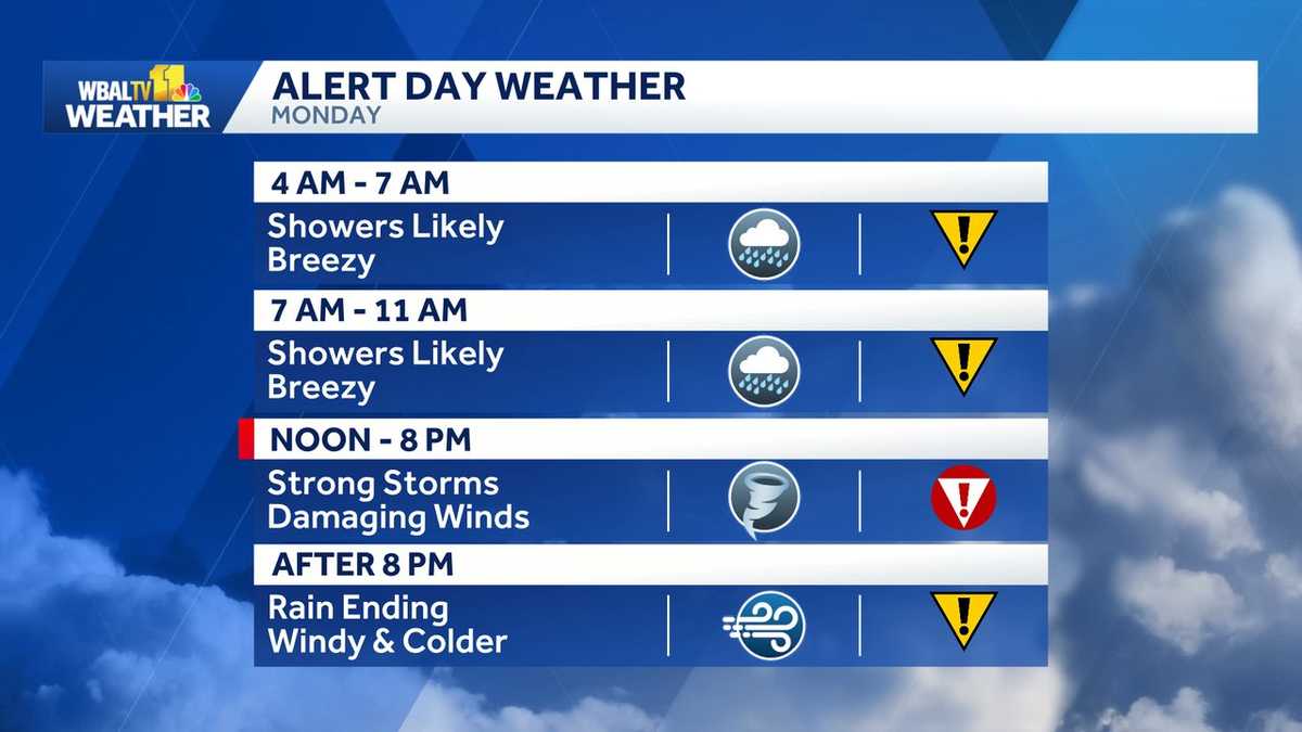
There is a rare level four (out of five) severe weather risk for parts of Maryland on Monday.
|| Closings/Delays | Weather Advisories | Radar | Forecast | Email Alerts | Send us your pics ||
Latest radar image (*updates every 10 minutes)

Severe weather\tornado risk
Much of Central Maryland will be one category short of the highest category for severe weather with a 10-15% chance of tornadoes developing.

Nothing is “for sure,” but this is a fairly unusual set up for this part of the country. It is uncommon for Maryland to have a tornado risk greater than 5%.
The 10% risk in Baltimore means there is a 10% chance that a tornado will occur within a 25-mile radius of any point in the affected area.
While damaging winds and tornadoes are possible for some areas in the Baltimore metro, it doesn’t mean everyone is going to see that kind of weather for sure — but it’s best to be prepared.

Severe storm timeline in Maryland
Meteorologist Tony Pann said the severe weather threat will be the highest in the afternoon and evening, but storms are possible from about 10 a.m. to 7 p.m. across the state.

Make sure phone notifications in the WBAL-TV 11 News app for weather alerts are set to on.
It will turn much colder overnight, with temperatures dropping into the 20s by Tuesday morning!
Know your safe place
As a reminder, during tornado warnings, go to a safe place in a middle, interior room of a sturdy building away from windows. The best place is in a basement, the lowest level of the building.
SchoolsAnne Arundel County schools will close two hours early Monday.Baltimore City schools will close two hours early Monday. Baltimore County schools will close three hours early Monday.Cecil County secondary schools close at 11 a.m., elementary schools close at noon Monday.Harford County schools will close three hours early Monday.
Maryland under ‘State of Preparedness’
Gov. Wes Moore has declared a State of Preparedness for severe weather in the forecast on Monday.
“In declaring a State of Preparedness for Maryland, I am directing the Department of Emergency Management to coordinate readiness efforts across state government in advance of the incoming severe storms,” Moore said in a statement. “The safety of Maryland families comes first. I am urging residents to prepare early, stay informed, and adjust plans, including postponing travel, as conditions change. Know the safest room at home or at work, and plan to be indoors before the storm arrives.”
According to the governor’s office, a State of Preparedness enhances the state’s ability to respond quickly to potential hazards and threats. Multiple state agencies and departments — including emergency management, transportation, law enforcement, and public health — are coordinating to prepare for the storm.
The Department of Emergency Management will activate the State Emergency Operations Center to respond to the storm and is closely monitoring as it approaches the state.
Potential for power outages
With the potential for power outages amid strong winds, Baltimore Gas and Electric said it’s mobilizing for the storm by increasing staffing to ensure crews are available to respond quickly and safely.
BGE said it’s particularly concern for the potential for high winds, which can have a severe impact on trees and power lines. Downed trees, limbs and other debris cause approximately half of all power outages during storms.
Report power outages in any of the following ways:
The latest outage information, including total number and general locations, is available on the BGE.com outage map.
As a reminder, fallen overhead power lines should never be approached or touched even if the lines do not appear to be live or sparking. Call BGE at 877-778-2222 to report fallen electrical lines, power outages and gas odors.
BGE advises customers to prepare by taking the following actions.
Keep bottled water and easy-to-prepare, non-perishable food on hand. Customers who rely on electricity for medical equipment, or who may be elderly or have disabilities, should confirm backup plans in case of an extended outage. Assemble an emergency kit with a battery powered radio, flashlight, first aid supplies, blankets, extra batteries, medications, and important phone numbers. Fully charge cellphones, computers, electric vehicles, and other devices before the storm arrives. If you have a landline, keep a corded phone available in case mobile devices lose power. Place a working flashlight with fresh batteries on each floor of your home. Do not use candles.
This developing forecast will be updated.

Download the WBAL-TV app NOW and turn on push alerts to be aware of severe weather warnings, listen to NOAA Weather radio, and watch WBAL-TV 11 when impending severe weather develops.
@wbaltv11 | @TTasselWBAL | @AvaWBAL | @TonyPannWBAL | @DalenciaWBAL | @AlenaLeeWX
WBAL-TV 11 Maryland Weather Radar
App users tap here for interactive radar.
Maryland’s 7-Day Weather Forecast

Alert Days vs. Impact Days
You may see the WBAL-TV 11 Weather Team highlight Alert Days or Impact Days in the forecasts. Here’s what that means:
An Impact Day is when weather will likely disrupt your normal daily schedule or routine.An Alert Day is when there’s a threat of extreme, severe and possibly life-threatening weather. Share your weather photos and videos
When and where safe, show us your weather photos and videos, we may show them on 11 News or online!